You are here
Summit of Saladin (Gutman).


Mountaineering routes in mountains of Central Tien-Shan.
“An amateur group of the All-Russian Central Council of Trade Unions under the command of Evgeniy Abalakov, consisting of: Vitaly Abalakov, Lorenz Saladin, Leon Gutman, Mikhail Dadiomov, climbed the western edge on September 5, 1936 at 11 o’clock to the top of Khan Tengri. The ascent began from the southern branch of the Inylchek glacier on the 30th at 22:00. Head of the Abalakov group."
A note left by climbers on the top of Khan Tengri.
Peaks in mountains of Central Tien-Shan.
Peak of Saladin (Gutman), 6201 meters above sea level, is located in mountains of Central Tien-Shan, in eastern part of Tengri-Too ridge almost at junction with Meridional ridge. According to the agreement of 2009, between the Kyrgyz Republic and the People's Republic of China, part of the Khan-Tengri peak and the territories located east of the peak were transferred to the Republic of China.
Accordingly, the peak of Saladin (Gutman) is located in China. The topographic maps of the USSR General Staff indicate the height of the peak - 6201 meters above sea level. Different sources indicate different heights and conflicting 5901, 5810 meters above sea level.
The peak is located in a small spur, which is located 1.5 kilometers from the main ridge of the Tengri-Too ridge. On the western side of the peak there is a cirque of the glacier. Torn on the eastern side there is a cirque from which the South Inylchek glacier begins.
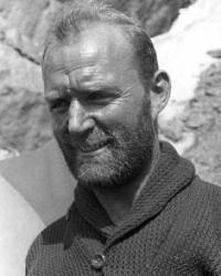
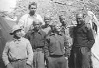
The peak is named in memory of Lorenz Saladin, a Swiss climber who took part in the third ascent of Khan Tengri in 1936, who died of frostbite at base camp. In September 1936, Leonid Gutman, as a student, climbed the western ridge to the Khan-Tengri peak 6995 meters above sea level as part of a group of Soviet climbers, which in addition to him included the Swiss political emigrant Lorenz Saladin, Mikhail Dadiomov, as well as masters of sports Evgeniy and Vitaly Abalakov.
They began the assault on the heights from the southern part of the Inylchek glacier on the 30th (according to other sources, the 31st) August 1936. Due to unfavorable weather conditions, the climbers had to spend two days in a snow cave deep in the glacier at an altitude of 5,650 meters.
On September 3, they reached the approaches to the top of Khan-Tengri and along the marble rocks reached 6,750 meters, where a third overnight stay was organized. On September 5 at 11 a.m. the highest point of the mountain was reached, and a traditional stone tour with a note was installed on its top.
It is worth noting that many years later, in 1954, a group of Soviet climbers led by Shipilov (Alma-Ata) discovered him on a rocky shelf and read the message they left. A review of the surrounding area from the top point revealed the presence of an unknown peak in the upper reaches of the Zvezdochka glacier, which could well be comparable in height to Khan-Tengri itself.
In those days, everyone believed that Khan-Tengri was the highest peak of the Central Tien-Shan and no one believed that there were seven thousand meters in its vicinity. While descending from the top of Khan Tengri, L. Gutman slipped, fell off the slope and, having rolled about 200 - 300 meters, seriously injured his head.
He managed to avoid death by luck by falling into a deep hole with snow. After spending the night in a snow cave, almost the entire crew of climbers received injuries and frostbite of varying severity. Having descended to the Inylchek glacier, they were lucky enough to attract the attention of local residents and military personnel of the border unit, however, despite calling a plane from Alma-Ata with rescuers and doctors, due to the development of gangrene, it was not possible to prevent the death of L. Saladin.
Lenz was buried on Inylchek at the confluence of two mountain rivers, near a colonnade of tall fir trees under a marble rock, Eugene wrote in pencil on the tombstone:
"Saladin Lenz. Died 17/IX/1936.” Evgeny Abalakov was no longer able to carve the inscription...
Unfortunately, Lorenz's burial site has been lost to the history of mountaineering. Only a few years ago Pyotr Ivanovich Solomatin found his grave.
Geographic coordinates of summit of Saladin (Gutman): N42°12'27 E80°12'55
Authority and photos by:
http://www.alpklubspb.ru/persona/Saladin_Lorenz.htm
http://www.pugachev.kg/


