


![]()
You are here
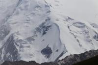
Akbaital glacier.
Nature in Akbaital ridge in Tajikistan.
“Into the snowy dust, a lonely monk.
Leave the fireplace to burn out.
Into the chilly lair of fugitive fear.
Bath your palms in mountain lakes"
Ramil Sabirov.
Travel to Akbaital glacier in Muzkol ridge.
Akbaital glacier is located at an altitude: upper limit is 5921 meters above sea level, end of glacier is 4727 meters above sea level, located at junction of Akbaital and Muzkol ridges, on territory of Tajik National Park, in Murgab region, Gorno-Badakhshan Autonomous Region.
The glacier is located on the northern slope of the Muzkol ridge in the Karakul Lake basin. The glacier consists of three branches: Central, Western and Eastern.
Glacier Central Akbaital.
The upper boundary of the glacier is located at an altitude of 5921 meters above sea level, the end of the glacier is at an altitude of 4727 meters above sea level. The length of the glacier is 5 kilometers, the area of the glacier reaches 5.7 square kilometers, the perimeter of the glacier is 13.08 kilometers, and the average width is 1.2 kilometers.
The tongue lies at an altitude of 4750 meters above sea level. The end of the glacier is covered with a thick moraine, so it is difficult to determine its boundaries. Filming of the glacier has been carried out since 1960. Currently it is retreating by 2-5 m/year.
Geographic coordinates of Akbaital Central glacier: N38°26'58 E73°33'02
Western Akbaital Glacier.
The upper boundary of the glacier is located at an altitude of 5596 meters above sea level, the end of the glacier is located at an altitude of 4788 meters above sea level. The length of the glacier is 3.1 kilometers, the area of the glacier reaches 2.66 square kilometers, the perimeter of the glacier is 4.2 kilometers, the width in the southern part of the glacier reaches 2.04 kilometers.
Geographic coordinates of Western Akbaital glacier: N38°27'02 E73°31'49
Eastern Akbaital Glacier.
The upper boundary of the glacier is located at an altitude of 5494 meters above sea level, the end of the glacier is at an altitude of 4925 meters above sea level. The length of the glacier is 5 kilometers, the area of the glacier reaches 0.72
square kilometers, the perimeter of the glacier is 16.28 kilometers, the width in the southern part of the glacier reaches 1 kilometer.
Geographic coordinates of East Akbaital glacier: N38°27'16 E73°34'16
Authority and photos by:
Alexander Petrov.