







You are here
Dzhankent medieval Settlement. S.P. Tolstov.
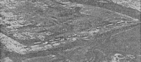
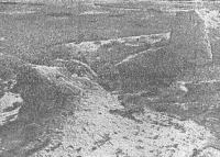
Between Jandarya and Kuvandarya Rivers.
"The type of Oghuz people who live in their cities, do not migrate to other places, and do not wage war are called Yatuk."
Mahmud of Kashgar. Encyclopedic Work "Divan of the Lugat at-Turk. 1074, XIth c."
Early Classical Monuments of Jeti-Asar.
In 1867, P. Lerch surveyed the Dzhankent Settlement near the mouth of the Syr Darya-the headquarters of the Oghuz Yabgu of the Xth-XIth centuries. The city of Yangikent (Turkic-Iranian "New City," Persian: Deh-i-Nau, Arabic: al-Qaryat-al-Hadith), like some other settlements (Sygnak, Sauran), has retained its early medieval name to this day and is therefore easily located. P. Lerch's small excavations (primarily of better-preserved ruins outside the city) allowed him, however, to identify only late medieval material (XIVth-XVth centuries).
This is not surprising, as the state of archaeological science at the time made it impossible to stratigraphically subdivide the finds and identify earlier layers of the city. After Lerch's work, the settlement was repeatedly visited, but never subjected to specialist study.
II. Settlements of Yangikent Group
In the autumn of 1946, the flight group of the Khorezm Archaeological and Ethnographic Expedition conducted a survey of the monuments of the old river basins of Jandarya and Kuvandarya. From the landing site of the expedition base, established near the ruins of Jan-kala (medieval Dzhenn), where fuel and provisions were dropped off by cars, a group of expedition members consisting of the leader S. P. Tolstov, research assistants M. A. Orlov and V. I. Psitman, who were also entrusted with aerial photography of the monuments, and pilots I. I. Yalovkin and P. D. Gubarev, in two PO-2 aircraft, after surveying the interfluve of Jandarya and Kuvandarya and the fascinating complex of early antique monuments of Jety-Asar, took off on October 10 along the route Dzhusaly - Kazalinsk - the ancient settlements of the Yangikent group.
After spending the night in Dzhusaly, on October 1st, the group, passing through Kazalinsk without landing, reached the Dzhankent settlement and landed in its vicinity. After surveying and photographing this settlement, that evening our aircraft flew to the Kuyuk-Kesken-Kala settlement, where we made a second landing.
Having spent the remaining hours before sunset exploring this site and spending the night, on October 12th, after completing the survey and aerial photography of Kuyuk-Kesken, we flew to Kuyuk-Kala, located at the southern end of the lowland peninsula adjacent to Kazalinsk, where we also landed.
Having completed our work there, we returned that same day via Dzhusaly to the Jety-Asar area, where we continued our work. The work was thus largely reconnaissance in nature. However, the material collected already allows us to draw a number of fairly definitive historical and cultural conclusions.
All three settlements are located in similar conditions. They lie on a flat, low-lying, damp, and highly saline plain on a triangular peninsula, or more accurately, an island, bordered to the north by the Syr Darya, to the west by the Aral Sea, and to the east by a strip of marshes and reed beds into which the Kuvan Darya oxbow river flows.
The island is intersected in various directions by the well-defined, mostly shrub-covered, dry channels of old deltaic channels, dividing it into numerous smaller islands. The location of all three settlements directly on the banks of these old channels suggests that the channels were active during the time of these settlements, and that, therefore, the settlements were located in an extremely marshy deltaic landscape, on small islands of the delta, at the corners of its branches, and near the seashore.
Description of Dzhankent settlement.
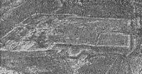
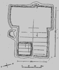
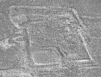
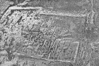
Situated in a heavily marshy and reed-covered area, it has a sub-rectangular shape, stretching from east to west (the eastern wall is oriented 15°), with a significant widening (steps on both sides) in the eastern half. Dimensions are 375 x 225 m (in the eastern part 300) m.
From west to east, approximately along the median, the settlement is divided by a main street running parallel to the walls, from which side streets branch off at right angles, dividing the area of the settlement into large residential quarters. In the northwestern corner is a square citadel mound measuring approximately 100 x 100 m, rising 7-8 m above the surrounding terrain, 3-4 m above the average level of the settlement area, and also built up.
large, massive houses. The outer walls of the settlement, except for the eastern one, have turned into a rampart up to 8 m high above the surrounding area, along which in places extensions are visible - traces of what were once towers - at unequal distances (25-40 m).
The eastern wall of the settlement is relatively well preserved. At its base, adobe masonry (bricks 40x40x9 cm) can be seen, above which there is pakhsa (clay) masonry preserved to a height of about 3 meters in rows 1.35 cm high, between which there are layers of reeds.
Pakhsa - from the cultural layer, contains numerous charcoal and remains of ceramics, among which there are many fragments of ancient red-glazed ceramics of the Khorezm types. The steppe is fortified with rounded towers located at a distance of about 30 m between the axes.
The towers are approximately 3 meters wide and project 3.5-4 meters. Approximately in the middle of the eastern wall is a well-preserved gatehouse, a semicircular projection of the wall approximately 15 meters long (from south to north), with a gate perpendicular to the wall at the northern end.
The projection is flanked by two outrigger towers. As in the medieval fortresses of Khorezm, the gatehouse was designed so that enemies would storm the gatehouse with their right side, unprotected by a shield, facing the city wall, thus exposing themselves to additional fire from the front – from the outrigger and from the left, from the outrigger tower flanking the approach to the gatehouse.
Literature.
P. Lerch. "Archaeological Journey to the Turkestan Region in 1867," St. Petersburg, 1870.
17 On the localization of early medieval Yangikent, see, in addition to the central works of P. Lerkha, Barthold, Turkestan, II, pp. 179-180; ditto, History of Irrigation of Turkestan, pp. 149-150, etc.; MITT, I, 150, note 9. t
18 V. Kallaur, Ancient Cities and Villages in the Perovsky District, in the Valley of the Syr Darya and Yana Darya Rivers, PTCL X, appendix to protocol 17/X1I 1903, no. 2.
19 E. Smirnov, Antiquities on the Middle and Lower Reaches of the Syr Darya River, PTCL, appendix to protocol November 17, 1897, pp. 1-14.
20 For a brief report on the work of the Khorezm expedition of 1946, see IOIF, 1947, No. 2; see also the map of monuments there.
21 For a justification for the location of this city, see our article, planned for publication in VDI. 12 We are publishing a preliminary description of the Jety-Asar complex in SA, XL.
Authority and photos by:
S. P. Tolstov. "The Cities of Guz." Historical and Ethnographic Sketches. Soviet Ethnography. Publishing House of the USSR Academy of Sciences. No. 3, 1947.