You are here
Sandalash river.

Excursion Central Asia and Uzbekistan tours.
“It is not the strongest of the species that survive, nor the most intelligent, but the one most responsive to change”
Charles Darwin.
Adventures in mountains of Central Asia.
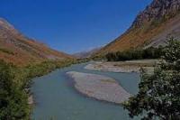
Sandalash - large right inflow of Chatkal - is logical technically difficult addition of a popular water route. The river begins from glaciers meridional Talas, and also the width - Pskem and Sandalash ridges. In the summer alloy can be begun with height of 2700 meters above sea level from Chakmak and Ashutor merge.
Forming Sandalash where leave on a track through the pass Ashutor (1A, 3600 m) from hydropoint Kurutigirek located in the valley of Chatkal. Height difference about 1 km. Area of a river basin Sandalash of 1157 square kilometers.
At the beginning the river a shallow rapid with a bias of 15 - 18 m/km. It is expedient to begin alloy from the mouth of a stream Qom Bel (height - 2300 m). Through the pass Qom Bel of 3250 meters the highway is above sea level paved.
An average consumption of water at the beginning of alloy (in September) - to 10 cubic centimeters a second, in the mouth - 30 cubic centimeters a second. Behind Kaymak mouth the wide valley of Chatkal opens.
Sandalash passes a rocky alignment and sharply falls in a narrow granite crack - the last rocky canyon with powerful thresholds. In a red granite canyon with height of walls to 10 m of 4 - 5 discharges up to 2 m high.
After the bridge through the river of an obstacle become simpler. Behind a farm on right to a beret Sandalash falls simple shivery into Chatkal, (on which further way is described in the previous route). The area of its catchment basin - about 1200 sq.km with a length of 89 km.
In certain places the river abruptly changes the direction. Sandalash accepts water of many inflows; the largest of them begin on slopes of the Pskem ridge: Kainsu, Kurgantyube, Chukursu, Talyksay, Achiktash, Karayangryk, Takmaksalda, Chongishakulda and Tayalmash.
Authority:
http://www.sijjak.com


