You are here
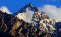
Glaciers of Ferghana Range.

Travel along routes in Uzbekistan.
“Old age begins from the moment when a person loses the opportunity to travel”
Unusual travel in Uzbekistan.
The Ferghana Range extends from the northwest to the southeast. Its average height in the western part is 3300 - 3500 meters above sea level, to the east it increases, reaching in the area of the junction with the Alai ridge 4500 - 4800 meters above sea level.
In the same direction, the number and size of glaciers are increasing. In total there are 383 glaciers on the Ferghana ridge with an area of 195.8 square kilometers. Glaciers are small, 83% of all glaciers are smaller than 0.5 square kilometers, only 3 are larger than 2 square kilometers.
The number is dominated by high-altitude glaciers, but about 75% of the total area of glaciation falls on the glaciers of the valleys. The largest of them are located in the higher southeastern part of the ridge. The size of 9 glaciers exceeds 3 square kilometers.
The largest is Palgov complex valley glacier (5.4 kilometers long, 7.4 kilometers square). Most large glaciers have a northeastern exposure, since snow transport plays a significant role in the transfer of snow by strong westerly and southwesterly winds to the leeward northeastern slopes.
The height of the ends of the glaciers increases from northwest to southeast from 3150 to 4800 meters above sea level. Their surfaces are relatively clean, moraine covered less than 3% of the area. There are many cracks on the valley glaciers, there are icefalls.
The surface slope in firn areas is 7 – 8 °, in tongues, 10 – 15 °. (Glacier catalog. 1968 - 1978).
Authority:
"Glaciers." L.D. Dolgushin, G.B. Osipova. Series "Nature of the world." Moscow, the publishing house "Thought". 1989.
Photos by
Alexander Petrov.


