You are here
Settlement Tortkultobe. Town Nizhniy Barskhan.


Monuments of Zhambyl region.
“Barskhan is a city at a distance of a mile to the east (from the previous one?), Has walls, now destroyed; the cathedral mosque is located among the bazaars.
“Barskhan is a city at a distance of two human voices from Taraz to the east, around it is a wall that has already collapsed. Cathedral mosque among the markets”.
Ibn Khordadbeh, "The Book of Ways and Countries." Qudama Ibn Ja'Far.
Cultural monuments of Zhambyl region.
Sources call the Lower Barskhan the next on the Silk Road in the direction to the east. According to the description of the route of Ibn-Khordadbeh and Qudama. Nizhny Barskhan was three farces from Taraz. It is said about him: “Barskhan is a city at a distance of two human voices from Taraz to the east, around it is a wall that has already collapsed. Cathedral mosque among the markets”.
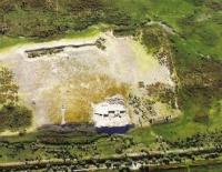
Lower Barskhan is identified in the settlement of Tortkultobe. located at a distance of about 15 kilometers from the ruins of Taraz (now - at the Talas railway station).
Aerial photography revealed its topography. The settlement looks like a two-tiered hillock, rectangular in plan, oriented by the sides along the cardinal points. The size of the hillock at the base is 140 x 140 meters, the height is 4 - 5 meters.
The northwestern corner is occupied by a hillock-shaped citadel (30 x 30 meters), 10 meters high. Shakhristan is surrounded on all sides by a swollen rampart with hillocks in place of towers at the corners and perimeter.
The highest wall, 8 meters, is the northern one, adjacent to the citadel. Entrances to the territory of shahristan, and there are two of them, are traced from the east and west sides. They are flanked by towers. From the side of the entrances to the settlement adjoin the sites - eastern (70 x 70 meters) and western (100 x 100 meters).
These are the remains of a rabad, here you can see the depressions - the remains of the Khauz. To the east of the settlement, buildings were traced in the form of separate hillocks - these are the remains of estates that were part of its agricultural district: the decoding of aerial photographs from large-scale maps made it possible to identify around the central ruins the remains of a long wall that surrounded the territory - it recedes from the central ruins by 1.5 - 2 kilometers.
Thanks to the splits in the citadel, it was possible to trace a group of rooms, rectangular and square in plan. Floor hearths and stone pavements were cleared in the fields. In one of the rooms there was a platform with dimensions of 2.5 x 3.7 meters made of pink kir (alabaster).
Near the site there was a hum, 1 meter high and 70 cm in diameter, dug into the ground. The structure, as it was possible to establish, is the remains of a winery.
Authority:
K.M. Baypakov. “Medieval settlements on the Great Silk Road”. Almaty, "Gylym". 1998.


