


![]()
Вы здесь
Ice and rock massif Kyzyl-Asker.
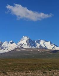
Mountain peaks in Kyzyl-Asker massif.
“But the severity of the grandeur was softened by boundless eternal beauty. The inexhaustible variety of forms, bold wild curves, and non-repetitive content captivate the poor human mind for a long time. These are not the tedious hours of everyday life, where boring petty life is repeated with regular precision, but a powerful upsurge of spirit, a disdainful indifference to what is too and too ordinary. This is how you feel when you look with admiration at the great snow-white wall that fills the earthly distances and attracts you to another world and other sensations. Of the many peaks, where none descends below 5000 m, 4 peaks stand out in particular. The first is the 5895 m height seen from the Kara-Chukur valley and the other three to the east, huddled in a small area. Of all of them, the two-headed peak seems to be the highest, which probably has a height of about 6000 m."
Palgov N.N. "Along the Central Tien-Shan". 1929.
Trip from Naryn to Kyzyl-Asker peak.
Kyzyl-Asker mountain-ice massif is located mainly in main ridge and northern spurs in western part of Kokshaal-Too ridge in At-Bashy district of Naryn region.
In the main ridge of the Kokshaal-Too ridge, ice giants rise, which, like giant battlements of an impregnable fortress, block the way from north to south. In the southwestern part, against the backdrop of twisting glaciers, the grandiose Kyzyl-Asker peak, 5842 meters above sea level, located on the main ridge of the western part of the Kokshaal-Too ridge, stands out.
In the latitudinal direction, it is surrounded by peaks and going to the west and east, lost in the distant haze and clouds. Kyzyl-Asker mountain range is characterized by a combination of typical nival-glacial landscapes combined with endless glaciation. In terms of its ice and water resources, the area is second only to the northern part of the Kokshaal-Too ridge, the Pobeda Peak area.
The entire area of the massif is a permafrost zone. The gentle northern slope below the glaciers contributes to the formation of swampy areas that extend to heights of 4100 meters above sea level. The snow line in the nival zone lies at an altitude of 4,000 to 4,500 meters above sea level.
The upper reaches and valleys of the rivers are at an altitude of 4,000 to 3,000 meters above sea level. The history of the development of the Kyzyl-Asker mountain range by climbers is not distinguished by a large number of successful ascents, the area is too harsh and remote.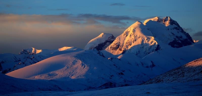
Сlimate in Kyzyl-Asker massif is distinguished by pronounced continentality, which is manifested in significant fluctuations in temperature and humidity. The region receives up to 2,965 hours of sunlight per year. The length of the Kokshaal-Too ridge, complex terrain and high altitudes create sharp temperature contrasts.
In January, the temperature varies: in the foothills in the southwest about -3 ° C, in the north -12 ° C, and in the highlands it reaches -22 ° C. In summer, the average temperature is 26–28 °C in the southwest, 22–24 °C in the north, and 5–10 °C in the mountains. At altitudes above 4,500 meters, negative temperatures are observed in July.
The amount of precipitation during the year decreases from west to east and from north to south. In the north, most of the precipitation falls in the summer, in the west and southwest - in the spring, and in the mid-mountain areas - in early summer.
In the Kyzyl-Asker mountain range, the annual precipitation exceeds 800 mm, with an average of 70–80% of the total precipitation falling from May to September. At altitudes of about 4,000 meters above sea level, over 90% of the annual precipitation falls as snow and ice, mainly on glaciers. Local mountain-valley winds are typical in this zone.
The snow line rises from the outer ridges to the central regions: in the north it is at an altitude of 3600 - 3800 meters, while in the Kyzyl-Asker region it reaches 4000 - 4500 meters above sea level.
Glaciation of Kyzyl-Asker mountain range.
The glaciers of the upper reaches of the Eastern Aksai and Uzengegush rivers are located on the northern slope of the Kokshaal-Too ridge. All the glaciers in this area are confined to the remains of ancient glaciers. In the center of this area, in the area of the Kyzyl-Asker peak, there is a glaciation node of the upper reaches of the Eastern Aksai and Uzengegush rivers - one of the largest in the Tien-Shan. In total, 14 glaciers with a total area of 82.25 square kilometers are concentrated in this area.
Valley glaciers predominate in number and area, with the majority of these glaciers and the largest of them grouped in the central part. These are valley and complex valley glaciers, occupying the upper reaches of meridional valleys and fed by firn fields, which stretch in a continuous strip along the axial part of the ridge, and from the gentle slopes of the lateral spurs.
The wide ends of large glaciers come out into the foothills zone, descending to a height of 3800 - 4300 meters above sea level. The largest glaciers of the Kyzyl-Asker massif belong to the basin of the Eastern Aksai River (from west to east):
Ak-Baital Glacier No. 87 is 5.5 kilometers long, the area of the glacier reaches 6.17 square kilometers, the perimeter is 13.3 kilometers.
Dzhirganaktu Glacier. No. 84 is 6.9 kilometers long, the area reaches 16.7 square kilometers, the perimeter is 29.25 kilometers.
Kyzyl-Asker Glacier ice west. No. 80 is 9.2 kilometers long, the area reaches 12.23 square kilometers, the perimeter is 21.66 kilometers.
Kyzyl-Asker Glacier East No. 80 is 7.4 kilometers long, the area reaches 9.06 square kilometers, the perimeter is 35.65 kilometers.
Komarova (Kyzylunet) Glacier West No. 78 is 7.6 kilometers long, the glacier area reaches 8.27 square kilometers, the perimeter is 19.3 kilometers.
Komarova (Kyzylunet) Central No. 78 is 9.4 kilometers long, the glacier area reaches 9.76 square kilometers, the perimeter is 24.68 kilometers. The glacier belongs to the Eastern Aksai River basin. Komarova (Kyzylunet) Vostochny No. 78 is 8.3 kilometers long, the area reaches 8.36 square kilometers, the perimeter is 19.46 kilometers, the greatest width in the central part reaches 1.1 kilometers.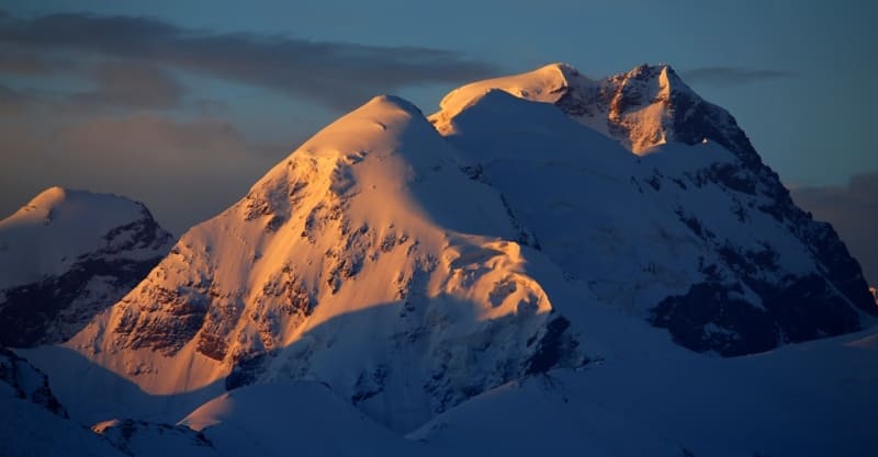
Uzengegush River Basin.
Mushketova (Oto-Tash, Kotur) No. 251 is 9.8 kilometers long, the area reaches 12.85 square kilometers, the perimeter is 26.74 kilometers, the greatest width in the upper part reaches 1.9 kilometers.
Nalivkina Glacier No. 248, 13.2 kilometers long, the area reaches 18.81 square kilometers, the perimeter is 30.57 kilometers, the greatest width in the upper part reaches 4 kilometers.
Malitsky Glacier No. 247 is 8.1 kilometers long, the area reaches 9.63 square kilometers, the perimeter is 25.95 kilometers, the greatest width in the upper part reaches 1.8 kilometers.
Ak-Baital Ice Massif.
In the west, the extreme spread of the Kyzyl-Asker mountain range is the Ak-Baital Ice Massif No. 87, 5.5 kilometers long. Here in the main ridge of the range is the highest peak of the massif - Ak-Baital, 4981 meters above sea level
Geographical coordinates of Ak-Baital peak: N41°01'38 E77°14'20
The next highest peak is Tochka potaty, 4872 meters above sea level, located in the main ridge of the Kokshaal-Too ridge, located 746 meters southeast of the Ak-Baital peak.
Geographical coordinates of Tochka potaty peak: N41°01'26 E77°14'48
The next peak is Cheynik, 4742 meters above sea level, located in the southern part of the spur extending north from the main ridge of the Kokshaal-Too ridge, located 1.1 kilometers northwest of the Ak-Baital peak.
Geographical coordinates of summit of Teapot: N41°02'01 E77°13'46
The summit is Ak-Baital East, 4709 meters above sea level, located in the eastern spur of the Ak-Baital glacier No. 87 extending north from the main ridge of the Kokshaal-Too ridge, located 1.5 kilometers northeast of the summit of Ak-Baital.
Geographical coordinates of summit of Ak-Baital East: N41°01'53 E77°15'19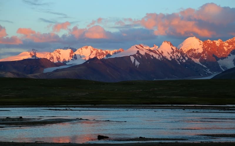
The summit is Belyi Veter, 4509 meters above sea level, located in the eastern spur of the Ak-Baital glacier No. 87 extending north from the main ridge of the Kokshaal-Too ridge, located 1.6 kilometers north and slightly east of summit of Ak-Baital East.
Geographical coordinates of White Wind peak: N41°02'41 E77°15'36
The farthest, northern peak of Dzhirganaktu, 4282 meters above sea level, is located in the northern part of the western spur, enclosing the Ak-Baital glacier No. 87, extending north from the main ridge of the Kokshaal-Too ridge, is located 7.7 kilometers north of the Ak-Baital peak.
Geographical coordinates of Dzhirganaktu peak: N41°05'50 E77°14'08
Dzhirganaktu ice massif.
Geographical coordinates of Jirganaktu glacier No. 84: N41°01'46 E77°16'23
The next glacier to the east of the Ak-Baital glacier No. 87 is the Jirganaktu ice massif No. 84, 7 kilometers long.
Here, in the main ridge of the Koshaal-Too ridge, is the highest peak of the massif – Nochnaya butterfly 5056 meters above sea level located 6.2 kilometers southwest of Kyzyl-Asker peak.
Geographical coordinates of summit of Night Butterfly: N41°00'47 E77°15'52
The next highest peak in the ice massif is the Lunar Rib 5102 meters above sea level, located in the main ridge of the Kokshaal-Too ridge, located 4.3 kilometers southwest of Kyzyl-Asker peak.
Geographic coordinates of summit of Moon Rib: N41°00'24 E77°17'36
The summit of Uygur is 4979 meters above sea level, is the third highest in the massif, is located in the main ridge of the Kokshaal-Too ridge, is 1.7 kilometers southeast of the summit of the Night Butterfly.
Geographical coordinates of summit of Uygur: N41°00'24 E77°17'36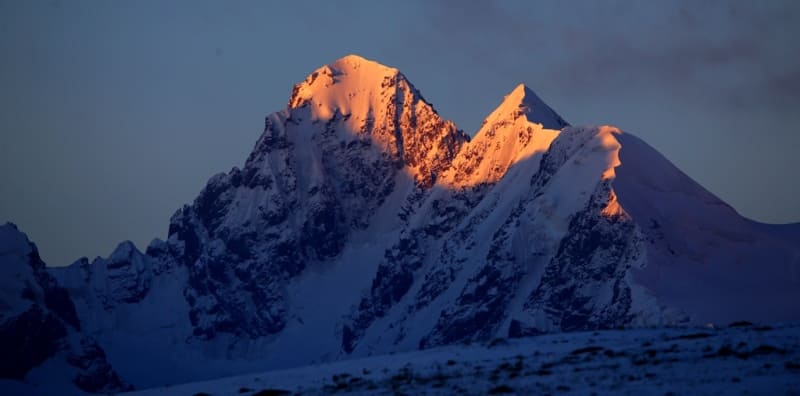
The summit of the Ice Dragonfly is 4892 meters high, 5102 meters above sea level, is located in the main ridge of the Kokshaal-Too ridge, is located 4.3 kilometers southwest of the peak of Kyzyl-Asker.
Geographic coordinates of Ice Dragonfly summit: N41°00'54 E77°14'29
The Krakow summit, 4841 meters above sea level, is located in the main ridge of the Kokshaal-Too ridge, 980 meters to the south and slightly west of the Nochnaya Babochka summit.
Geographical coordinates of Krakow summit: N41°00'17 E77°15'43
The Kafedra summit, 4786 meters above sea level, is located in an ice spur that is the border between the Jirganaktu glaciers No. 84 and Kyzyl-Asker Zapadny No. 80 and extends north from the main ridge of the Kokshaal-Too ridge, located 2.7 kilometers northeast of the Nochnaya Babochka summit.
Geographical coordinates of summit of Kafedra: N41°01'23 E77°17'39
The summit of Poni, 4705 meters above sea level, is located in the western part of the ice spur, which is the border between the glaciers of Jirganaktu No. 84 and Kyzyl-Asker West No. 80 and extends north from the main ridge of the Kokshaal-Too ridge, located 3.2 kilometers northeast of the summit of Nochnaya Motochka.
Geographical coordinates of summit of Poni: N41°02'03 E77°17'25
Kyzyl-Asker ice massif.
The ice massif consists of 10 grandiose glaciers, which we will describe in sequence from west to east:
Kyzyl-Asker West Glacier, 9.2 kilometers long.
Geographic coordinates of Kyzyl-Asker West Glacier No. 80: N41°04'07 E77°19'21
The following peaks are concentrated in the spur of the western part of the glacier, 11 kilometers long, extending north from the main ridge of the Kokshaal-Too Range:
The nameless peak, 5632 meters above sea level, is located 2.2 kilometers southwest of the main peak of Kyzyl-Asker, 638 meters south and slightly east of the Bely Voron peak.
Geographical coordinates of nameless peak: N41°01'07 E77°18'45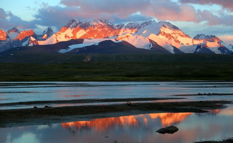
The Bely Voron peak, 5262 meters above sea level, is located 638 meters north and slightly west of the nameless peak, 5262 meters above sea level.
Geographical coordinates of White Raven summit: N41°01'27 E77°18'37
The Raven summit is 5,370 meters above sea level and is located 207 meters northwest of the White Raven summit.
Geographical coordinates of Raven summit: N41°01'33 E77°18'30
The Stone Horse summit is 5,186 meters above sea level and is located 600 meters north and slightly east of the Raven summit.
Geographical coordinates of Stone Horse summit: N41°01'49 E77°18'30
The Butterfly's Paw summit is 4,865 meters above sea level and is located 1.1 kilometers northwest of the Stone Horse summit and 1.3 kilometers northeast of the Pony summit.
Geographical coordinates of Butterfly's Paw peak: N41°02'24 E77°18'13
Following peaks are concentrated on the ridge of the eastern part of the glacier, 8 kilometers long, extending north from the Kokshaal-Too ridge, which is the border between the Western and Eastern Kyzyl-Asker glaciers:
The main peak of Kyzyl-Asker, 5842 meters above sea level, is located on the main ridge of the Krokshaal-Too ridge, 1.3 kilometers southwest of the Eastern Kyzyl-Asker peak and 1.3 kilometers south and slightly west of the Northern Kyzyl-Asker peak.
Geographic coordinates of Main Peak of Kyzyl-Asker: N41°01'41 E77°20'07
Peak Kyzyl-Asker North is 5413 meters above sea level, located 1.3 kilometers to the north and a little to the east of the Main Peak of Kyzyl-Asker.
Geographical coordinates of peak of Kyzyl-Asker North: N41°02'22 E77°20'15
Peak Obzornaya is 4835 meters above sea level, located 1.9 kilometers to the north and a little to the west from the summit of Kyzyl-Asker Severny.
Geographical coordinates of summit of Obzornaya: N41°03'25 E77°20'02
Summit of Panoramanaya is 4716 meters above sea level, located 854 meters northeast of the summit of Obzornaya.
Geographical coordinates of Panoramnaya peak: N41°03'48 E77°20'22
Kyzyl-Asker East Glacier No. 80, 7.4 kilometers long,
Geographical coordinates of Kyzyl-Asker East Glacier No. 80: N41°03'48 E77°20'53
Following peaks are concentrated in the rocky-ice spur of the western part of the glacier, 8 kilometers long, extending north from the Kokshaal-Too ridge:
Kyzyl-Asker East Peak, 5085 meters above sea level, is located in the main ridge of the Kokshaal-Too ridge, 1.1 kilometers southeast of Kyzyl-Asker North Peak and 63 meters northwest of the Kyzyl-Asker East Pass height of 5107 meters
above sea level.
Geographical coordinates of peak of Kyzyl-Asker East: N41°02'04 E77°20'56
Rock wall Zabor with a length of 2.4 kilometers with a dominant height of 4849 meters above sea level is located in the upper reaches of the Kyzyl-Asker East glacier No. 80 to the west of the border spur between the Kyzyl-Asker East and West glaciers.
In the internal and closed rock-ice spur with a length of 2.3 kilometers, located in the upper reaches of the Kyzyl-Asker Vostochny glacier, extending north from the Kokshaal-Too ridge, there are 2 peaks:
Summit of the Panfilov Division, 5126 meters above sea level, is located 900 meters to the northeast of the summit of Kyzyl-Asker Vostochnaya and 582 meters to the south and slightly to the west of the summit of the Cathedral.
Geographical coordinates of summit of tPanfilov Division: N41 ° 02'27 E77 ° 21'20
Summit of Cathedral, 4799 meters above sea level, is located 582 meters to the north and slightly to the east of the summit of the Panfilov Division.
Geographic coordinates of Cathedral peak: N41°02'45 E77°21'28
Komarov Glacier West (Kyzylunet) No. 78, 7.6 kilometers long.
Geographical coordinates of Komarov Glacier (Kyzylunet) West No. 78: N41°04'36 E77°22'19
Following peaks are concentrated in the rocky-ice spur of the western part of the glacier, 9 kilometers long, extending north from the main ridge of the Kokshaal-Too ridge:
Unknown Soldier peak, 5,300 meters above sea level, is located 1.4 kilometers northeast of the Kyzyl-Asker East peak, 830 meters southeast of the Panfilov Division peak.
Geographic coordinates of Unknown Soldier peak: N41°02'18 E77°21'54
The Okhrovaya Wall peak is 5038 meters above sea level, located 691 meters to the east and a little to the south of the Cathedral peak, 632 meters to the north of the Unknown Soldier peak.
Geographic coordinates of Okhrovaya Wall peak: N41°02'40 E77°21'56
Bolshaya Belaya peak is 4977 meters above sea level, located 1.8 kilometers to the north of the Okhrovaya Wall peak, 2.2 kilometers to the east and a little to the south of the Obzornaya peak.
Geographic coordinates of Bolshaya Belaya peak: N41°03'38 E77°21'54
Kyzyl-Asker Central Glacier No. 78, 9.4 kilometers long.
Geographic coordinates of Komarov Glacier (Kyzylunet West No. 78): N41°04'36 E77°22'19
In upper reaches of Kyzyl-Asker Central Glacier, in main ridge of Kokshaal-Too Range, is located:
Babushka peak, 5282 meters above sea level, is located 1.7 kilometers southeast of the Unknown Soldier peak, 1.9 kilometers southwest of the Vostochny Komarova Pass, 4969 meters above sea level.
Geographical coordinates of Babushka peak: N41°01'49 E77°22'57
Mushketov Glacier (Oto-Tash, Kotur) No. 251, 9.8 kilometers long.
Geographical coordinates of Mushketov Glacier (Oto-Tash, Kotur) № 251: N41°04'34 E77°26'06
There are two passes at head of glacier in main ridge of Kokshaal-Too ridge:
Kitaisky, 4947 meters above sea level, and Promezhutochny, 5038 meters above sea level.
Following peaks are concentrated in 11-kilometer-long rock-ice spur extending north from main ridge of Kokshaal-Too ridge, which is border between Mushketov (Oto-Tash, Kotur) glaciers № 251 and Nalivkina № 248:
Pyramid peak, 4889 meters above sea level, is located 1.7 kilometers southeast of the Unknown Soldier peak, 1.9 kilometers southwest of the Komarova Vostochny pass, 4969 meters above sea level. seas.
Geographic coordinates of Pyramid peak: N41°02'29 E77°26'00
The Obzornaya peak is 5082 meters above sea level, located 1.8 kilometers northeast of the Pyramid peak, 2.6 kilometers northeast of the Trezubets peak.
Geographical coordinates of Obzornaya peak: N41°03'16 E77°26'48
Pervaya peak is 4508 meters above sea level, located 2.3 kilometers to the east and slightly south of the Znachkistov peak, 3.7 kilometers to the north and slightly east of the Obzornaya peak.
Geographical coordinates of Pervaya summit: N41°05'17 E77°27'03
Following summits are concentrated in the 9.8-kilometer-long rocky-ice spur extending north from the main ridge of the Kokshaal-Too ridge, which is the border between the Mushketov (Oto-Tash, Kotur) No. 251 and Komarova Vostochny No. 78 glaciers:
Trezubets summit, 5,093 meters above sea level, is located 1.8 kilometers northwest of the Pyramid summit, 2.6 kilometers west and slightly south of the Obzornaya summit.
Geographic coordinates of Trezubets summit: N41°03'05 E77°24'56
Znachkistov summit is 4668 meters above sea level, located 2.3 kilometers to the west and slightly north of the Pervaya summit, 2.6 kilometers to the west and slightly south of the Obzornaya summit.
Geographical coordinates of Znachkistov summit: N41°05'30 E77°25'27
Nalivkina Glacier No. 248, 13.2 kilometers long.
Geographic coordinates of Nalivkin Glacier No. 248: N41°03'10 E77°27'45
Following peaks are located in the upper reaches of the Nalivkin Glacier in the main ridge of the Kokshaal-Too Range:
August Letavet peak, 5471 meters above sea level, is located in the main ridge of the Kokshaal-Too Range, 1.2 kilometers southeast of the Druzhba peak, 2 kilometers west and slightly north of the Trapeziya peak.
Geographical coordinates of Augusta Letaveta peak: N41°01'27 E77°25'40
The Druzhba peak, 5089 meters above sea level, is located 1.2 kilometers northwest of the A. Letaveta peak, 2.4 kilometers southwest of the Pyramid peak.
Geographic coordinates of Druzhby peak: N41°01'34 E77°24'48
Trapezium peak is 5050 meters above sea level, located 2 kilometers east of A. Letaveta peak, 742 meters northwest of Golodny peak.
Geographical coordinates of Trapezium peak: N41°01'20 E77°27'04
Golodny peak is 5129 meters above sea level, located 740 meters southeast of Trapezium peak, 1.4 kilometers southwest of Korsun peak.
Geographical coordinates of Golodny peak: N41°01'11 E77°27'34
Fersman West Glacier No. 238, 14.2 kilometers long.
Geographic coordinates of Fersman Glacier West #238: N41°01'08 E77°30'20
Following peaks are located in the upper reaches of Fersman Glacier West in the main ridge of the Kokshaal-Too Range:
Bely Peak is 5671 meters above sea level, located 1.3 kilometers to the east and slightly south of Golodny Peak, 2.3 kilometers to northwest of Ann Peak.
Geographical coordinates of Bely Peak: N41°01'05 E77°28'31
Neizvestny Peak is 5130 meters above sea level, located 926 meters to the southwest of Ann Peak, 815 meters to the west and slightly north of Zastava Peak.
Geographic coordinates of Neizvestny peak: N40°59'52 E77°29'05
The Ann peak is 4805 meters above sea level, located 926 meters northeast of the Neizvestny peak, 664 meters north of the Zastava peak.
Geographical coordinates of Ann peak: N41°00'08 E77°29'39
The Zastava peak is 5070 meters above sea level, located 815 meters east and slightly south of the Neizvestny peak, 664 meters south of the Ann peak.
Geographical coordinates of Zastava peak: N40°59'47 E77°29'40
In the intermediate spur in the upper part of the Fersman West glacier, the Plaza peak is located at an altitude of 4905 meters above sea level, located 2.6 kilometers northeast of the Ann peak, 2.5 kilometers west and slightly north of the Krylya Sovetov peak.
Geographical coordinates of Plaza peak: N41°00'54 E77°31'12
In the main ridge of the Kokshaal-Too ridge, at an altitude of 4880 meters above sea level, there is the Kitayskoye Sedlo pass, which is the border between the Fersman West and Fersman South glaciers located on the southern slope of the ridge in the People's Republic of China.
Geographical coordinates of Kitayskoye Sedlo Pass: N40°59'57 E77°28'01
In a short spur extending north from the main ridge in the Kokshaal-Too Range is the Sarychat Pass, 4020 meters above sea level, which is the upper boundary between the Fersman West and East glaciers. The pass is named after the river that flows from the common tongue of the Fersman Glacier in its northern part.
Geographical coordinates of Sarychat Pass: N41°00'19 E77°31'25
Further to the east, there is a conditional border between the Kyzyl-Asker and Dankov massifs along the spur that separates the Fersman East glacier No. 238 (Sarychat) and Palgova No. 231.
The Kyzyl-Asker massif is one of the most impressive mountain regions of the Tien Shan, located on the border of Kyrgyzstan and China and includes many of the highest peaks in the region. This massif is part of the Kokshaal-Too ridge system and is famous for its high peaks, glaciers and harsh climatic conditions.
The massif includes several significant peaks, among which the most famous is the Kyzyl-Asker peak, 5842 meters above sea level. It is a complex mountain structure with steep slopes, ice walls and hard-to-reach routes, making it popular among experienced climbers.
The massif contains large glaciers that feed rivers flowing into the central regions of the Tien-Shan. The glacier system plays an important role in the hydrology of the region, providing water to the surrounding valleys. The Kyzyl-Asker massif has long attracted the attention of climbers and explorers seeking to conquer its peaks.
The first ascents in this area began during the Soviet period, when geographers and climbers actively explored the Central Tien Shan. Today, this massif remains one of the most difficult to climb due to its remoteness, inaccessibility and harsh natural conditions.
The Kyzyl-Asker mountain range is one of the most beautiful and hard-to-reach places on the map of the Central Tien-Shan. Its majestic peaks, glaciers and extreme conditions make it attractive to climbers, explorers and wildlife enthusiasts. This area remains one of the last little-studied corners of mountainous Kyrgyzstan, preserving its pristine nature and uniqueness.
Geographical coordinates of Kyzyl-Asker mountain-ice massif: N41°03'28 E77°22'27
Authority and photos by:
Alexander Petrov.