


![]()
You are here
History exploration of Western Kokshal-Too
 (1882 - 1973).")


.")
.")

.")
Off-road tours on roads Tien-Shan mountains.
"None of the local residents know who owns the Chon-Terek tract: every summer, the Chinese Kyrgyz roam in this tract due to the accessibility of the Terek pass, and in the winter, sometimes Russian Kyrgyz also come along the ice of the Chon-Uzengyu-Kuush river, which, flowing among the gorges , completely inaccessible in summer"
Military topographer, Lieutenant Ledomsky.
Trip to Kokshaal-Too mountains.
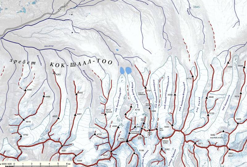
The name of the Kokshaal-Too ridge comes from the Kyrgyz "kok shaal" - "belts" (the term "putlische" means a belt on which the stirrup is hung to the saddle). For the first time, Western Kokshal-Too was described by the Russian geographers A.V. Kaulbars, who in 1869 led an expedition exploring the area south of the Naryn River. (AV Kaulbars. "Materials on the geography of the Tien Shan").
It was one of the many expeditions that were sent to the Tien-Shan in those years in connection with the growing interest of Russia in Central Asia. Kaulbars continued and supplemented the work begun by the expeditions of P.P. Semenov in 1856 - 1857.
In 1867, Nikolai Alekseevich Severtsov (1827 - 1885), a Russian zoologist and traveler, visited it. The expedition organized by him passed from the southern shore of Issyk-Kul the Barskaun gorge, the Dzhuuka pass and reached the upper reaches of the Naryn, the Akshiirak ridge and descended to the Ak-Sai river and Chatyr-Kel lake.
Thus, Severtsov moved further and closer to the Kokshaal-Too ridge than Peter Petrovich Semyonov (Tien Shan) who visited the Inner Tien Shan, reaching the upper reaches of the Naryn River 10 years before Severtsov.
In 1870, a military detachment arrived in the region - in those years, the Russian Empire was resolving the border issue with China and, in addition, as a result of the Dungan-Uyghur uprising in China and the difficult military-political situation in East Turkestan, it took into its citizenship a part of the territory of Xinjiang in the upper the course of the Ili River, headed by the city of Kuldzha.
During the detour of the border regions, Baron Alexander Vasilyevich Kaulbars (1844 - 1929), the future general of the cavalry and the first commander of the Russian army aviation (1915), and then the senior adjutant of the headquarters of the Semirechensk region, visited Western Kokshaal-Too, put at the head of the Russian embassy in Gulja (protectorate of Russia from 1871 to 1881).
The detachment of A.V. Kaulbars ascended the Kubergenti pass, crossed the Kagalyachap plateau and descended to the west along the Myudyurum river (one of the Ak-Sai tributaries, originating from the Kyzyl-Asker glaciers) and mapped the hitherto unknown Kokshaal-Too and Borkolda ridges (then Borkoldoy was mistaken for a lateral spur of Kokshaal-Too - and in some ways this idea turned out to be correct, since here the watershed passes precisely along Borkoldoy, and not along Kokshaal).
Next, Western Kokshaal-Too was visited by researchers as part of the expeditions of Nikolai Mikhailovich Przhevalsky (the route of the return of the expedition in 1883 - 1885) and Mikhail Vasilyevich Pevtsov (the beginning of the route from Karakol, the expedition of 1889 - 1990).
Among the participants in these expeditions were the famous travelers V. I. Roborovsky, P. K. Kozlov and geologist K. I. Bogdanovich. These expeditions were not devoted to the study of the Tien Shan, their main goal was the Kun-Lun and Tibet ridges, besides, the routes of these expeditions crossed the Western Kokshaal-Too through the Bedel pass, located slightly east of the breakthrough of the Uzengi-Kuush river, that is, far east of Kyzyl -Askera, so the researchers could not see this mountainous area even from afar.
In 1906, 1907 and 1909 the Hungarian geologist Gyula Prinz (1882 - 1973), made long journeys in the Central Tien Shan. He discovered the Uzengegush River, mapped the main glaciers and peaks of the region (G. Prince "Highlands of the Tien Shan").
For an overview of the area, he climbed a small but remarkable peak Kyzyl-Ompol. This was the first ascent in the area. The prince explored and mapped glaciers and peaks in the headwaters of the Chon-Turasu River, the right tributary of the Uzengegush River.
He discovered the Uzengi-Kuush river (originates east of the Kyzyl-Asker peak), to which he passed from the Naryn syrts through the Ashu-Su and Karakoz passes). He was also the first to climb up the Chon-Turasu valley (in its upper reaches there is Dankov peak, 5982 meters above sea level - the highest point of Western Kokshaal-Too) and mapped the main glaciers and peaks of the region.
There is reason to believe that the results of his research were not known to some followers, and therefore it would be extremely interesting to look at the archives of his expeditions. In 1910 - 1911, a topographic survey of the region was carried out by the Turkestan Military District. It is known that the 1911 expedition was commanded by Lieutenant Ledomsky.
According to one of the versions, Dankov Peak, the highest point of Western Kokshaal-Too, is named after one of the topographers, but this version is doubtful, since Dankov's surname is not in the lists of officers of the KVT (Corps of Military Topographers) of the Russian army (590 names) and it has not been found either according to the lists of other divisions of the army, including the General Staff, which had a relation to KVT.
Topographers led by Ledomsky did not manage to make a topographic survey in the Uzengegush valley in the eastern part of the region, because they were met there by hostile Chinese Kyrgyz and, avoiding conflict, decided to leave.
Therefore, even after these expeditions, on the published maps of Semirechye, the area east of Kagalyachap appeared to be a blank spot - from the breakthrough of the Ak-Sai river in the west to the Sary-Dzhas river in the east, no lowering of the ridge was indicated, except for the Bedel pass, known from the VIIth century - that is, the river Uzengi-Kuush was not on the map at all.
Also, the right (western) tributaries of the Sary-Dzhas were not marked. This uncertainty served as one of the prerequisites for the recent revision of the boundaries and the transfer to China of the entire basin of the Uzengi-Kuush River (from the watershed on the Kagalyachap plateau to the Bedel ridge, the border runs from the north along the watershed of the Bokoldoy ridge).
The next in these places was in 1912 the Russian botanist and geographer Vasily Vasilyevich Sapozhnikov (1861 - 1924), who later managed to serve as the minister of public education in the Kolchak government in Siberia.
It was the descriptions of Sapozhnikov, who, in the course of botanical and geographical expeditions in Semirechye, visited the Kagalyachap plateau and described the northern slopes of the Western Kokshaal-Too, that were used by further expeditions.
The break in research associated with the anti-Russian uprisings in present-day Kyrgyzstan and Kazakhstan in 1916, which followed the revolution and the civil war, lasted until 1929, when the area was visited by two expeditions at once - the geologist N.M. Prokopenko, who crossed the area, moving along the route Karakol - Uzengi-Kuush - Naryn, and the geographer and glaciologist N.N. Palgov (a glacier in this area is named after him), which gave names to the glaciers Komarov, Ototash (Mushketov), Nalivkin, Mallitsky and Fersman.
The information of N. Palgov's expedition attracted the attention of climbers and tourists from the tourist section of the Moscow House of Scientists, who in the summer of 1933 went on their vacation to the first tourist trip in this area, organizing it for scientific purposes, and also in the hope of making the first ascents there.
It was this expedition that gave the names to the main peaks of the region, including the Kyzyl-Asker peak. The study of Western Kokshal-Too was continued in 1929, the geographer N. Palgov, who carried out the first glaciological studies here, gave names to some glaciers in the western part of the ridge (N. Palgov "Along the Central Tien Shan." - Izv. RGO, vol. 62, issues 1 - 3, 1930), and the geologist Prokopenko.
The tourists of the Moscow House of Scientists also took an active part in the study of the region, who under the leadership of Avgust Andreevich Letavet (1893 - 1971) in 1933 - 1934 visited and described the glaciers of the central part of the ridge in the area of Dankov Peak.
Letavet gave names to these glaciers (Palgov and Grigoriev glaciers in honor of famous geographers). He also named the peaks of the region - the peaks of Kyzyl-Asker (Krasnoarmeets), peaks Dzholdash, Shmidt, Alpinist.
In the upper reaches of the Chon Turasu river, the first sports ascent to the top of 4900 meters above sea level was made, later named after one of the climbers of the Maron. In 1938, Letavet will lead an expedition, during which the troika L. Gutman - E. Ivanov - A. Sidorenko will ascend the "peak of the 20th anniversary of the Komsomol", which later turns out to be the peak of Victory that was not yet discovered.
The expedition of 1933 included Professor V.V. Nemytsky, K.S. Letavet (wife of A.A. Letavet), V.K. Goltsman and M.M. Holtzman. In 1938, the first mountaineering expedition of the Krylya Sovetov sports society headed by B. Smagin went to Western Kokshal-Too. An attempt to storm the summit "Wings of the Soviets", due to bad weather, ended unsuccessfully.
In 1935 and 1937 (in the interval between the climbing expeditions of A. Letavet, 1934 and B. Simagin, 1938), the Department for the Protection of Mineral Resources of the Kyrgyz SSR carried out a geological survey of the area of the Komarov glacier (glaciers 78 (Komarov) - 81)
Geographic coordinates of the Western Kokshaal-Too ridge: N41 ° 03'21.68 "E77 ° 02'59.62"
Authority:
"Research of glaciers in the USSR" 1935, issue 2 - 3 under the title "New data on glaciation in the Chakyr-Korum, Borkoldy and Kok-shaal ridges" (authors - A. Letavet, V. Nemytsky).
"On the glaciers and peaks of Central Asia", Dmitry Zatulovsky, Moscow, OGIZ-Geografgiz, 1948.