


![]()
Вы здесь
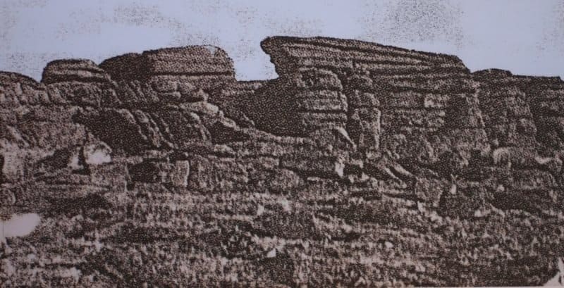
Kalmyk walls in Karkaraly.

Trip from Karaganda to Pavlodar.
"At the very foot of the Karkaraly Mountains, on the hills near the city, the remains of some kind of wall are well preserved. The Cossacks, like everything ancient, call it Chudskaya, the Kyrgyz call it Kalmykskaya. The wall was built along the granite ledges of the hills, with the low areas filled with broken granite. The wall is especially clearly visible in the gorges among the hills. It stretches, like a ribbon, for a very long distance. The granite is old, weathered; here and there, large hewn slabs can be found, but without inscriptions or images. The Karkaraly region long served as the arena of fierce struggle between the Kalmyks (Dzungars) and the Kyrgyz, right up until the defeat of Dzungaria by the Chinese in the 1950s. Russian power was effectively consolidated here only about seventy-five years ago (the Karkaraly District was formed in 1824), and until then, the Karkaraly Kirghiz were essentially independent. In the entire vast expanse (182,430.6 square miles) comprising the district, as I mentioned above, there is still only one Russian settlement—the town of Karkaraly (or Karkaraly) with a Cossack village, where there are slightly more than a thousand Russians".
N. Ya. Konshin. "From Pavlodar to Karkaraly." 1901.
"At the Karkaraly Prikaz itself, in a narrow gorge where the Zharym-Su River flows, a wall has been erected, blocking access to a vast valley surrounded by very high mountains. Along the crests of these mountains, apparently with extraordinary effort, a wall of uncut stone slabs has been built, 7 arshins high in some places, 5 arshins in others, and 3 arshins thick. This fortification, extending for several miles in circumference, was undoubtedly built by the primitive inhabitants of the steppe."
Governor-General and Commander of Eastern Siberian Troops S.B. Bronevsky. "Otechestvennye Zapiski." 1930.
Monuments of the Karkaraly mountains.
Kalmyk Wall (Kalmyk Wall) near Karkaraly.
"Kalmyk Rampart" is the local name for an extended stone embankment/bank (or series of ramparts) made of granite slabs that runs along the edge of the forest near Karkaraly and extends deep into the Karkaraly Mountains. According to oral histories and regional publications, it was a massive structure 2 - 3 meters wide, up to 3 meters high, and stretching for 4 - 6 kilometers at its longest sections; today, scattered fragments and lines of ramparts remain in tracts (for example, Suykbulak).
Very little remains today - virtually nothing in its original form. The stones were used for other building materials, hauled away, and broken. People remember stories of a grandiose human creation - the fortress wall known as the "Kalmyk Rampart."
It must be assumed that thousands of people and 100,000 tons of stone slabs were needed to build such a structure! It is noted that old sections can still be found in gorges and among the hills - traces of the wall are visible there: broken lines of shattered granite, individual hewn slabs.
It turns out that the slabs from which the wall was built were transported to the city by the residents of Karkaraly over the course of a century as excellent building material. They used the finished wild stone to lay foundations and walls, erect barns, and fence their garden plots.
As Semipalatinsk local historian N. Ya. Konshin notes, even at the beginning of the XXth century, some sections of the wall were clearly visible, especially in gorges among the hills - the wall stretched like a ribbon, far away, made of old, weathered granite, with occasional "large hewn slabs, but without inscriptions or images."
It's important to know that Zharymsu is the now-forgotten name of a section of the Karkaralinka River, beginning at its emergence from the forest thicket. If you emerge at the edge of the forest in the Bolshaya Karkaralinka River gorge, traces of a stone rampart are immediately apparent: a two-meter-wide strip of crushed granite intersected the riverbed, rose to the crest of a rocky ridge, and headed south, following every curve of the treeless ridge.
It descended into the valley of the Suukbulak Stream, and, ascending another hill, ended as it began - at the edge of the forest. If you imagine the space enclosed by the rampart, you'd imagine a vast, securely protected field. Indeed, its vast expanse could easily accommodate tens of thousands of head of cattle!
There is currently no reliable evidence that this archaeological site is 4,000 to 5,000 years old. Some researchers claim it was built by the Andronovo people, residents of the ancient settlement of Suukbulak. They believe that, as our ancestors, building a wall was clearly beyond their capabilities. In all likelihood, the defensive ridge arose during the Tatar-Mongol invasions or even later, during the heyday of the Dzungar Khanate.
Historical information and hypotheses about "stone wall" in Karkaraly.
Researchers (including local historians, S. B. Bronevsky is mentioned) described the Kalmyk rampart in the early XXth century, documenting its sections and taking measurements. According to descriptions, the rampart blocked access to the valley at one point, where an old route passed through a gorge of rivers and ridges.
There are no definitive archaeological excavations that would officially confirm the rampart's purpose: a defensive fortress wall, a property boundary, a religious structure - all are hypothetical.
The precious lines of an eyewitness preserved for us the condition and location of the deserted, abandoned fortification:
"Near the Karkaraly Prikaz, in a narrow gorge where the Zharymsu River flows, a wall was erected, blocking passage to a vast valley surrounded by very high mountains, along the crests of which, apparently with extraordinary labor, a wall of wild stone slabs was built, in some places seven, in others five arshins high and three arshins thick. This fortification extends for several miles in circumference."
It is believed that the Stone Wall played its strategic role until Kazakhstan's annexation by Russia. In 1731, Khan Abulkhair was the first to accept citizenship from his northern neighbor, and in 1782, the central part of Kazakhstan also became part of Russia.
Since then, the rampart was abandoned, gradually falling into disrepair and being dismantled for economic needs. And yet, this wall holds secrets that science has yet to unravel. For example, how long is it? One eyewitness estimated it to be 120 miles.
And what about the lack of ruins of a settlement within the fortification? Some believe the fortress was a kind of summer residence: people hid there and waited out danger. It's quite possible they used it as a corral for hunting wild animals and keeping livestock.
Legends and folk tales about "stone wall" in Karkaraly.
According to one legend, the rampart was erected by ancient people to protect their settlement from adversity - steppe enemies or raiders. The wall supposedly ended where nature itself created a barrier. People say that in ancient times, when the glaciers were still melting, passages through the forests were dangerous: the "Kalmyk rampart" served as a landmark - if you saw broken stone from the wall, you were following the old path that led to the "forest shrines."
There is a well-known version of this.
At the end of the last century, archaeologist V.P. Nikitin recorded an interesting legend in Karkaraly, which names the architect of the fortress wall - the Karkaraly batyr Malai-Sary. He "chose a valley protected by large, almost sheer mountains for his camp; but since it was surrounded by mountains on only three sides, he built a wall on the fourth side, where there were no mountains and where the terrain was open to raids."
This wall long served as a defense or boundary for the Sara family's holdings and lost its significance only with the arrival of the Russians."
Meaning and usefulness of "stone wall" in Karkaraly.
Cultural: The rampart is part of the local heritage, a symbol of Karkaraly's antiquity. It conceals unsolved mysteries - sources of inspiration for legends and stories. Tourism: Even in its ruined state, the remains of the rampart are of interest to tourists as a historical landmark.
It can be included in routes as an observation point, especially during forest walks around Karkaraly. ogically, the wall should be located on a ridge, thus reinforcing natural obstacles with artificial structures. Furthermore, even today, the artificial origin of the wall is clearly visible.
In some places, large flat stone slabs stand vertically dug into the ground. Smaller stones are scattered between these stones. The weathered rocks in the Karkaraly Mountains are layered flat stones. There are no vertically or inclined slabs among them.
Authority:
Advertising booklet of Karkaraly National Park, 2003. Nature reserve - Karkaraly mountains.