


![]()
Вы здесь
Photo tour of Turgai geoglyphs in Kazakhstan.
Tours to Turgai in Kazakhstan.
"Longest Roundabout - Closest Way Home"
A brief description of the route of travel to the mysterious sights of the south of Kostanay region:
Arkalyk - geoglyph "Ushtogay square" - Amangeldy village - geoglyph "Turgay swastika" - geoglyph "Shiilisky square" - geoglyph "Ashchytysty cross" - geoglyph "Turgai ring" - Arkalyk.
Distance of the route: 541 km.
Season: May - September.
The best time for an excursion: July - September.
Duration of the trip: 3days.
Advanced reservation: 48 hours.
A detailed program of a trip to the nature of the sights of Arkalyk:
Excursions to sights of Turgai in Kostanay region.
Day 1. Arkalyk - geoglyph "Ushtogay square" - Amangeldy settlement (305 km).
Transfer: Arkalyk - the old mausoleum of Keiki batyr (north-west of the village of Tasty) (72 km).
The Keiki (Nurmagambet) Kokembayuly mausoleums are located 4.5 kilometers northeast of the Tasty village. The first (old) mausoleum is located 600 meters south of the Arkalyk-Turgai highway. The mausoleum was built in 1996.
During the construction of the mausoleum, natural stones were used; a bust of the national hero was installed inside the mausoleum. In 2005 the mausoleum was restored. Visit to the mausoleum. Geographic coordinates of the old Keiki Batyr mausoleum: N50 ° 28'55,00 "E66 ° 01'52,13"
Transfer: old mausoleum of Keiki batyr - new mausoleum of Keiki batyr (1 km).
On September 15, 2017, under the “Rukhani Zhangyry” program, on the Arkalyk - Turgai highway, on the south side, in the vicinity of the village of Tasty, the Keiki Batyr mausoleum was opened. At the grand opening of the mausoleum, the remains of the national hero were buried. Geographic coordinates of the new Keiki Batyr mausoleum: N50 ° 29'07.81 "E66 ° 01'49.37" Visiting the mausoleum.
Further transfer: Keiki batyr mausoleum - Kutan aulie mausoleum (21 km).
On the way, in the vicinity of the Taubulak ravine, there is a spring of the same name, here you can replenish supplies with good drinking water. The Kutan Auliye mausoleum is located in the interfluve of the Karynsaldy and Ashytasty, 1.5 kilometers south of the Arkalyk - Turgai highway, in the Amangeldy district, in the south of the Kostanay region.
From the village of Zhaldama, the mausoleum is located 8 kilometers to the north-east. Kutan Aulie, belongs to the Naiman clan, the people nicknamed him "Baqanalynyk turt taqany". The Kutan Auliye (1690 - 1780), who was popularly considered "Auliye", had the gift of foresight. Kutan auliye was distinguished by wisdom, intelligence and insight.
Visit to the mausoleum. Geographic coordinates of the Kutan Auliye mausoleum: N50 ° 28'28.76 "E65 ° 45'44.35"
Further transfer: mausoleum Kutan auliye - Zhaldama village - Ushtogay village – “Ushtogai square” geoglyph (89 km).
From the Kutan auliye mausoleum, our way lies to the west, in the village of Zhaldama we turn to the northwest and move to the village of Ushtogay. Arrival at the geoglyph. The geoglyph "Ushtogay square" is located in the eastern part of the Kostanay region, in the north-east of the Amangeldy region, 163 kilometers north-west of the town of Arkalyk.
"Ush togai" in translation from the ancient Türkic is translated as border forest "" Ush "- border, border, outskirts. The geoglyph "Ushtogay square" is located in the southwestern part of the Saryadyr mountain range, which stretches in the latitudinal direction for 84 kilometers and has a maximum elevation of 290 meters above sea level.
In the southern part of the hilly Karakuduk mountains, which belong to Saryadyr, with an elevation of 197 meters above sea level, stretching from south-west to north-east for 9 kilometers and is the "Ushtogai square". From the village of Ushtogay to the geoglyph 15 kilometers.
"Ushtogay square" - is a geometric figure - a square with diagonals, presented from 101 mounds in the form of mounds, approximately the same size. Burial mounds with a diameter of 11 to 15 meters, a height of about 1 meter.
The eastern side of the square is 279 meters long, the western side of the square is 272.5 meters long. The square is oriented diagonally to the cardinal points. Approximately 112 meters from the northwest corner, three rings, each 19 meters in diameter, are located diagonally. Walk in the vicinity of the geoglyph.
Geographic coordinates of the geoglyph "Ushtogay square" - N50 ° 50'00.66 "E65 ° 19'37.84"
Transfer: geoglyph "Ushtogay square" - Ushtogay village - Zhaldama village - Amangeldy settlement (122 km). Arrival in the settlement of Amangeldy, accommodation at the hotel, overnight.
Day 2. Settlement Amangeldy - geoglyph "Turgai swastika" - geoglyph "Ashytasty cross" (143 km).
Breakfast. The settlement of Amangeldy is located 145 kilometers west of Arkalyk, on the right bank of the Kara-Turgai River at the mouth of the Zhaldama River. The village of Amangeldy is the administrative center of the Amangeldy district. The settlement is named after the leader of the 1916 national liberation uprising in Kazakhstan, Amangeldy Imanov.
Until 1936, the village was called Batbakkara, in 1936, by the decree of the Central Executive Committee of the USSR, the village of Batbakkara was renamed Amangeldy. Visit to the historical museum of Amangeldy Imanov.
The museum was opened in 1969. Since 1979, it has been located in a new building, which houses 5 exhibition halls, 2 offices, a cinema hall, a storage facility. The museum houses more than 2000 exhibits, including personal belongings, weapons and household items of Amangeldy Imanov and his associates: match guns, sabers, daggers and other things.
Sightseeing tour of the settlement, visiting: burial place, monument and headquarters of Amangeldy Imanov, monument-bust of A. Nurmanov (writer, author of the novel "The Death of a Kulan"), mausoleum of Gabdollauly Satybaldy Ishan at the cemetery in the settlement.
Transfer: Amangeldy settlement - Karashatobe village - Kara-Turgai river - Urpek village - Agashtykol village – “Turgai swastika” geoglyph (19 km).
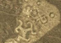
From Amangeldy our way lies to the southeast, we pass several villages, a bridge over the Kara-Turgai river and soon we are at the mysterious place of Turgai. The geoglyph "Turgai swastika" is located in the eastern part of the Turgai hollow, on the right bank of the Kara-Turgai river in the Amangeldy district of the Kostanay region, at an altitude of 145 meters above sea level.
From the settlement of Amangeldy to the geoglyph - 19 kilometers. "Turgai Swastika" is located on the north-western shore of Lake Agashtykol, 411 and 542 meters from the village of Agashtykol to the southeast.
The geoglyph is a mound in the form of a three-beam swastika. Each of the rays ends in a zigzag shape, the ends of which are bent counterclockwise. The height of the embankment is up to 0.3 meters, the length of the beam is about 33 meters, the width at the base is 13 - 15 meters, and the width at the end is 10 - 12 meters.
Zigzag shapes 40-50 meters long, 5 - 6 meters wide, curved parts 15 - 20 meters long. In the center of the structure there is a depression with a diameter of 4 meters and a depth of up to 0.3 meters. The swastika fits into a circle with a diameter of about 90 meters.
Near the structure there are small embankments with a diameter of 10 - 15 meters, a height of 0.2 - 0.3 meters, surrounded by a moat. Geographic coordinates of the “Turgai Swastika” geoglyph: N50 ° 06'12.09 "E65 ° 21'40.33"
Transfer: geoglyph "Turgai swastika" - lake Agashtykol - village Kyzylzhuldyz - geoglyph "Shiilisky square" (56 km).
From the geoglyph "Turgai swastika" we move to the east, pass Lake Agashtykol from the west and then move along the southern bank of the Kara-Turgai river, then along the southern tributary of the Karasu river. In the village of Kyzylzhulduz we ford the Kara-Turgai river and soon we are at the geoglyph "Shiliisky square".
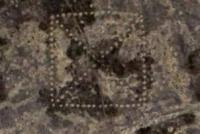
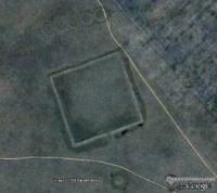
Geoglyph "Shiliysky square" is located in the eastern part of the Zhylanshykturme upland. In the interfluve of the Kara-Turgai, which is 7 kilometers south, the drying up Taldysai channel, which is 3.5 kilometers to the west and the drying up Shilisay, 6 km in the east, flowing through the village of Kayindy.
7 kilometers to the east is the village of Kayindy and 78 kilometers to the northeast is the town of Arkalyk. The geoglyph is located on the territory of the town administration of Arkalyk, Kostanay region. "Shiliisky square" is a square area surrounded by a rampart and a moat located on the outside.
The side of the square is about 225 meters long. The width of the shaft is 10 - 12 meters, the height is 1 - 1.5 meters, the width of the ditch is 10 - 12 meters, the depth is up to 1 meter. In the southern part, there is an entrance to the structure, represented by a rupture of a rampart and a ditch.
A hundred meters south of the square there is a mound with a flat top, the embankment was built of earth, the embankment diameter is 30 meters, the height is 1.5 meters, it is ringed with a moat up to 10 meters wide and up to 0.8 meters deep.
One hundred meters to the north of the square, there are five circles, which are platforms ringed with a shaft and lined up parallel to the side of the square. Circle diameter 30 - 35 meters, shaft width 4 - 5 meters, height 0.2 - 0.3 meters. Walk in the environs.
Geographic coordinates of the geoglyph "Shiilisky square": N50 ° 01'40.19 "E65 ° 59'56.75"
Transfer: geoglyph "Shiilisky square" - the village of Kayindy - the village of Alua - geoglyph "Ashchytasty cross" (55 km).
On the way, visit the dilapidated mazar Baksy mall, burial of the healer. Our path lies east to the village of Kayindy. Having passed the village, the drying out bed of the Karakudduk River and the small village of Alua, we turn to the north-east.
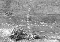
Approximately, after 38 kilometers we ford the river Ashytasty and soon we are at the geoglyph "Ashtysty cross", next to which is the Krestovaya elevation, 252 meters above sea level. The geoglyph "Ashtysty cross", which is sometimes called "Koktausky cross", is located in the interfluve, Ashtysty, which is located 3.6 kilometers in the south and the drying channel Zhusalysay, 8.5 kilometers to the north and the bed of the Zhosaly river flowing into 10.5 kilometers to the east, which is the right tributary of the Ashytasty River.
The village of Koktau is 18 kilometers to the east, the town of Arkalyk is 51 kilometers to the east. The geoglyph is located on the territory of the town administration of Arkalyk, Kostanay region. The geoglyph "Ashtysty cross" is equally oriented to the cardinal points.
84 meters north of the northern part of the cross there is a rampart in the western part and three burial mounds to the east of it. The large "Ashtysty cross" is a cruciform figure, which consists of 38 embankments. The figure is 436 meters long. Geographic coordinates of the geoglyph "Ashtysty cross": N50 ° 13'39.56 "E66 ° 17'30.56"
Transfer: geoglyph "Shiilisky square" - the river Ashytasty - Kala burial mounds (13 km).
From the Krestovaya volcano our way lies to the north along the eastern bank of the Ashchytasty river. We pass the Zhusin winter road and on the picturesque right bank of the Ashtytasty river we will stop for the night. On the opposite bank of the river, 400 meters from the camp, there are two Kala burial mounds. Walk to the burial mounds. Overnight in tents.
Day 3. Transfer Burial mounds of Kala - the town of Arkalyk (93 km).
Breakfast. Transfer: Kala burial mounds - geoglyph "Turgai (Ashtysty) ring" (21 km).
Our way from the camp lies to the north along the eastern bank of the Ashtytasty river. We pass the channel of the river Zhusalysay, the channel and the ravine of Arshaly and soon we are at the geoglyph "Turgai ring".
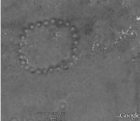
On the way, sightseeing of a group of mounds (geographical coordinates of a group of mounds: N50 ° 22'01.51 "E66 ° 10'03.73"). Arrival to the geoglyph "Turgai ring". The geoglyph "Turgai Ring" is located in the interfluve of the Ashtytasta, which is 1.8 kilometers in the south, the drying up channel of the Zhusalysay, 15 kilometers to the southeast and the channel of the Tasty River, which flows 13.6 kilometers in the north-west, which is the right tributary of the Ashtysty River.
16.5 kilometers in the north-west is the village of Tasty, 56 kilometers in the south-east is the town of Arkalyk. The geoglyph is located on the territory of the town administration of Arkalyk, Kostanay region. The geoglyph "Turgai Ring" is a circle that consists of 25 embankments, 170 meters in diameter.
There are three ring ditches to the north of the “Turgai Ring”. A group of several burial mounds is located 1.2 km east of the “Turgai Ring” geoglyph, and three burial mounds are located 220 meters to the southwest. In 5, 2 kilometers to the northwest there is a group of 4 burial mounds stretched in a line from the southwest to the northeast.
Walking in the environs. Geographic coordinates of the “Turgai ring” geoglyph - N50 ° 22'05.82 "E66 ° 09'00.56"
Transfer: geoglyph "Turgai ring" - a group of three burial mounds (5 km).
From the geoglyph "Turgai ring" our path lies along the hilly terrain, northwestward to three mounds. Walk in the environs. Geographic coordinates of the group of three burial mounds: N50 ° 24'30.84 "E66 ° 07'13.39"
Transfer: three Burial mounds - the town of Arkalyk (67 km).
Arrival to Arkalyk. End of the trip.
Note:
Author program of Alexander Petrov. Copying and introduction from the sanction of the author.