


![]()
You are here
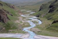
Adyrtor river. Saryjaz tributary.
Hydrography of Saryjaz ridge.
"The water can carry the boat, or it can turn it over."
Chinese proverb.
Tributaries of Saryjaz River.
The Adyrtor River is located in the northeastern mountains of the Central Tien Shan in the Ak-Suu district of the Issyk-Kul region. The length of the Adyrtor River is 23 kilometers. Its beginning is at an altitude of 3424 meters above sea level at the end of the tongue of the Mushketov glacier.
The mouth of the river is located at an altitude of 3109 meters above sea level. The Adyrtor River is a left tributary of the Sarydzhaz River. The right tributaries of the river are not significant, as a rule, they are all unnamed.
The main right tributaries are concentrated on the southwestern slope of the Rebta Adyrtor and originate from the Adyrtor peak 4304 meters above sea level. The longest of them is an inflow with a length of 3 kilometers.
In total, Adyrtor receives 9 tributaries-streams on the right for 11 kilometers. In the upper reaches, the Adyrtor is formed from three channels, two of them originate from the Mushketov glacier and one tributary flows down from the glacier located on the northern slope of the Sarydzhaz ridge.
After the confluence of the left tributary of the Kashkantor River, the Adyrtor River flows through the valley of the Saryjaz River. The speed of the river reaches 1.2 meters per second, the width of the river reaches 10 meters or more, the bottom of the river is rocky.
Left-bank tributary of the river Adyrtor.
Achikto river.
7.4 kilometers after the source, the Adyrtor takes on the left the Achkto River with a length of 4.3 kilometers. The sources of the Achikto River begin at an altitude of 3469 meters above sea level from the tongue of a glacier 4.5 kilometers long flowing down from the northern slope of the Saryjaz ridge.
At an altitude of 3274 meters above sea level, Achekto flows into the Adyrtor on the left.
Geographic coordinates of the Achikto River: N42 ° 16'25.50 "E79 ° 42'32.15"
4 nameless tributaries flowing from the glaciers of the north-eastern slope of the Sarydzhaz ridge flow between the Achkto and Kashkantor rivers on the left.
Kashkantor river.
8 kilometers after the confluence of the Achikto river into the Adyrtor, the Kashkantor tributary, 7.3 kilometers long, flows on the left. The source of the river begins at an altitude of 3709 meters above sea level from a 2.4 km long glacier located on the northern slope of the Saryjaz ridge.
The mouth of the river is located at an altitude of 3158 meters above sea level in an expanding river valley, which gradually merges into the Saryjaz valley.
Geographic coordinates of the Kashkantor River: N42 ° 19'27.04 "E79 ° 38'18.51"
Geographic coordinates of the Adyrtor River: N42 ° 21'02.97 "E79 ° 38'53.12"
Authority and photos by
Alexander Petrov.