


![]()
You are here
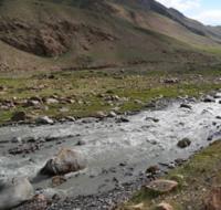
Akshiyrak River.
Mountain rivers of Kyrgyzstan.
“We don’t notice the air, but without it we suffocate. So it is with living nature. Only when we lose it completely will we realize what we have lost..."
Nikolai Sladkov.
What rivers are there in Kyrgyzstan?
Akshiyrak River originates from southern slopes of Akshiyrak ridge and northern slopes of Kokshaal-Too ridge and is located in Jety-Oguz region in outh of Issyk-Kul region. 84 kilometers before the Saryjaz River crosses the state border of the Kyrgyz Republic and the People's Republic of China, the Akshiyrak River flows into the right.
The Akshiyrak River, at an altitude of 2875 meters above sea level, is formed from the confluence of two tributaries: the western tributary Cholok-Koichisai and the eastern Kayche. The length of the Akshiyrak River from the confluence of these two rivers is 35 kilometers.
1 kilometer before the confluence of Akshiyrak, a large, full-flowing tributary, Dzhangart, flows into the Saryjaz River on the right. On the left, in addition to the described tributaries, the Akshiyrak River has 22 more nameless streams. On the right, the river receives 13 nameless, small tributaries.
Geographic coordinates of Akshiyrak River: N41°50'08 E78°49'31
Right tributaries of Akshiyrak River.
Dzhangart River.
Dzhangart River is located at an altitude: sources are 3685 meters above sea level, mouth of river is at an altitude of 2341 meters above sea level, river is right tributary of Akshiyrak River, originates from northern slopes of eastern part of Kokshaal-Too ridge, is located in Jety-Oguz region in south Issyk-Kul region.
17.9 kilometers after the Tashlysu River flows into Akshiyrak, a large and full-flowing tributary Dzhangart with a length of 31.3 kilometers adjoins on the right.33.2 kilometers from the beginning of the source (the confluence of the Cholok-Koichisai and Kayche rivers), the Dzhangart River flows into Akshiyrak from the right.
At the confluence of the Dzhangart and Akshiyrak rivers, 1.1 kilometers remain before their confluence with the Saryjaz River. The river receives its sources from six large valley glaciers located on the northern slope of the Kokshaal-Too ridge (the description of the glaciers is presented from east to west).
The easternmost tributary flows from the Chuloktor Western glacier with a length of 11 kilometers. The glacier is located on the northern slope of the Kokshaal-Too ridge; its sources are located at an altitude of 4971 meters above sea level. The glacier's area is 10.72 square kilometers. The perimeter of the glacier is 26.56 kilometers.
Geographic coordinates of Chuloktor Western glacier: N41°41'15 E78°59'35
The next river flows from the Akoguz Vostochny glacier with a length of 7.3 kilometers. The glacier is located on the northern slope of the Kokshaal-Too ridge; its sources are at an altitude of 4911.2 meters above sea level. The glacier's
rea is 5.05 square kilometers. The glacier's perimeter is 15.39 kilometers.
In the middle part, between the Chuloktor Western and Akoguz Eastern glaciers, there is an unnamed peak 5318 meters above sea level.
Geographic coordinates of Akoguz Eastern glacier: N41°41'43 E78°56'51
The next tributary flows from the Akoguz Central glacier with a length of 6.6 kilometers. The glacier is located on the northern slope of the Kokshaal-Too ridge; its sources are at an altitude of 4275.2 meters above sea level. The glacier's area is 9.11 square kilometers. The glacier's perimeter is 17.98 kilometers.
Geographic coordinates of Akoguz Central glacier: N41°40'29 E78°55'53
The next tributary flows from the Akoguz Western glacier. The total area of the glacier is 8.07 square kilometers. The glacier has two branches - eastern and western. The length of the eastern branch of the glacier is 5.4 kilometers. The area of the eastern branch of the glacier reaches 4.08 square kilometers, the perimeter of the glacier is 11.38 kilometers.
The length of the western branch of the glacier is 5.2 kilometers. The area of the eastern branch of the glacier reaches 3.3 square kilometers, the perimeter of the glacier is 11.6 kilometers. The glacier is located on the northern slope of the Kokshaal-Too ridge; its sources are located at an altitude of 4805 meters above sea level.
In the upper reaches of the Akoguz Western glacier in its southern part there is an unnamed peak 5291 meters above sea level
Geographic coordinates of Akoguz Western glacier: N41°40'42 E78°54'12
The next tributary flows from the Dzhangart-Tynbashi East glacier. The area of the glacier is 9.06 square kilometers, the perimeter of the glacier is 23.3 kilometers. The length of the glacier is 8.7 kilometers. The glacier is located on the northern slope of the Kokshaal-Too ridge; its sources are located in the main ridge at an altitude of 5060 meters above sea level.
Geographic coordinates of Dzhangart-Tynbashi Eastern glacier: N41°38'44 E78°53'48
The next tributary flows from the Dzhangart-Tynbashi Central glacier. The area of the glacier is 16.91 square kilometers, the perimeter of the glacier is 22.84 kilometers. The length of the glacier is 8.1 kilometers. The glacier is located on the northern slope of the Kokshaal-Too ridge; its sources are located in the main ridge at an altitude of 5048 meters above sea level.
Geographic coordinates of Dzhangart-Tynbashi Central glacier: N41°37'49 E78°52'04
The next tributary flows from the Dzhangart-Tynbashi Western glacier. The area of the glacier is 5.51 square kilometers, the perimeter of the glacier is 16.26 kilometers. The length of the glacier is 5.51 kilometers. The glacier is located on the northern slope of the Kokshaal-Too ridge; its sources are located in the main ridge at an altitude of 4977 meters above sea level.
To the west of the Dzhangart-Tynbashi Western glacier there is the Dzhangart Pass, 4181.7 meters above sea level, through which in Soviet times geologists built a survey and technological road. In the northern part, the glacier is strongly torn by transverse cracks.
The Dzhangart-Tynbashi Western glacier in the northern part ends in a vast, moraine lake with a length of 1.06 kilometers, the greatest width of the lake in the central part is 440 meters. The area of the lake reaches 0.38 square kilometers, the length of the coastline is 2.73 kilometers. The tongue of the glacier ends in a semicircle into the lake. The lake is located on the moraine part of the glacier.
Geographic coordinates of Dzhangart-Tynbashi Western glacier: N41°40'07 E78°49'37
The next tributary flows from the Dzhangart-Tynbashi Western glacier. The area of the glacier is 5.51 square kilometers, the perimeter of the glacier is 16.26 kilometers. The length of the glacier is 5.51 kilometers. The glacier is located on the northern slope of the Kokshaal-Too ridge; its sources are located in the main ridge at an altitude of 4977 meters above sea level.
To the west of the Dzhangart-Tynbashi Western glacier there is the Dzhangart Pass, 4181.7 meters above sea level, through which in Soviet times geologists built a survey and technological road. In the northern part, the glacier is strongly torn by transverse cracks.
Geographic coordinates of Dzhangart River: N41°47'34 E78°57'10
Right tributary of Dzhangart River.
Sauktor River.
12 kilometers before the confluence of the Dzhangart River with the Akshiyrak River, the 12.8-kilometer-long tributary Sauktor flows into Dzhangart on the right. After 8.4 kilometers from the beginning of the sources of the Dzhangart River, the Sauktor River flows into the right.
In the upper reaches, the river is formed from four main tributaries, which originate from glaciers: Sauktor, Sauktor West, Kichik Sauktor and Chuloktor East. In addition to the main tributaries described below, 5 small tributaries flow into the Sauktor River on the right and 4 on the left.
The easternmost tributary flows from the Sauktor glacier. The area of the glacier is 9.45 square kilometers, the perimeter of the glacier is 24.32 kilometers. The length of the glacier is 9.6 kilometers. The glacier is located on the northwestern slope of the Kokshaal-Too ridge; its sources are at an altitude of 5190 meters above sea level. In the southeastern part of the glacier there is the Sauktor pass with a height of 4583.6 meters above sea level.
Geographic coordinates of Sauktor glacier: N41°43'55 E79°06'26
To the east of the Sauktor glacier, behind a small latitudinal spur, there is the Sauktor Western glacier with a length of 4.7 kilometers. The area of the glacier is 3.6 square kilometers, the perimeter of the glacier is 12.15 kilometers. The sources of the glacier are located at an altitude of 5190 meters above sea level.
Geographic coordinates of Sauktor Western glacier: N41°44'09 E79°04'21
The middle tributary flows from the Kichik Sauktor glacier. The area of the glacier is 7.19 square kilometers, the perimeter of the glacier is 19.96 kilometers. The length of the glacier is 8.3 kilometers. The glacier is located on the northwestern slope of the Kokshaal-Too ridge, the sources of the glacier are in the main ridge at an altitude of 5025 meters above sea level.
In the southern part of the ridge, in the main ridge of the Kokshaal-Too ridge, there is the Kichik-Sauktor pass, 4678 meters above sea level.
Geographic coordinates of Kichik Sauktor glacier: N41°43'04 E79°03'08
The next tributary flows from the Chuloktor Vostochny glacier. The area of the glacier is 5.58 square kilometers, the perimeter of the glacier is 15.84 kilometers. The length of the glacier is 4.9 kilometers. The glacier is located on the northwestern slope of the Kokshaal-Too ridge; its sources are located in the main ridge at an altitude of 5025 meters above sea level.
Geographic coordinates of Chuloktor Eastern glacier: N41°42'30 E79°01'09
Geographic coordinates of Sauktor River: N41°45'46 E79°03'04
Left tributaries Dzhangart.
Achiktyshsay River.
After 6.1 kilometers from the beginning of the source, a small tributary of 3.8 kilometers long, Achiktyshsay, flows into Dzhangart on the left, at an altitude of 3448 meters above sea level. Achiktyshsay originates from the Achiktyshsay glacier located in the ridge between the Akshiyrak and Dzhangart rivers, stretching from west to east and northeast for 35 kilometers.
In this ridge, in its central part, there is a vast area of glaciation stretching from southwest to northeast for 20 kilometers. The area of the glacier is 1.38 square kilometers, the perimeter of the glacier reaches 8.1 kilometers. The length of the Achiktyshsay glacier is 3.9 kilometers. The sources of the glacier are located at an altitude of 4891 meters above sea level.
Geographic coordinates of Achiktyshsay River: N41°42'39 E78°51'38
Tuzmasai River.
3 kilometers after the Achiktyshsay River flows into Dzhangart, a small tributary of 4.1 kilometers long, Tuzmasai, flows into the left. In the upper reaches, the Tuzmasai River is formed from two tributaries. One of the tributaries originates from the Tuzmasay glacier located in the eastern slope in the ridge between the Akshiyrak and Dzhangart rivers, stretching from west to east and northeast for 35 kilometers.
In this ridge, in its central part, there is a vast area of glaciation stretching from southwest to northeast for 20 kilometers. The area of the Tuzmasay glacier is 0.85 square kilometers, the perimeter of the glacier reaches 4.18 kilometers. The length of the Tuzasai glacier is 1.4 kilometers. The sources of the glacier are located at an altitude of 4361 meters above sea level.
Geographic coordinates of Tuzmasay River: N41°43'30 E78°53'24
Aksai River.
After 11.2 kilometers from the beginning of the source, a small tributary of 2.7 kilometers long, Aksai, flows into Dzhangart on the left. In the upper reaches, the Aksai River is formed from two small tributaries. The main tributary originates from the small Aksai glacier located on the eastern slope in the ridge between the Akshiyrak and Dzhangart rivers, stretching from west to east and northeast for 35 kilometers.
In this ridge, in its central part, there is a vast area of glaciation stretching from southwest to northeast for 20 kilometers. The area of the Tuzmasay glacier is 0.86 square kilometers, the perimeter of the glacier reaches 4.09 kilometers. The length of the Tuzasai glacier is 1.5 kilometers. The sources of the glacier are located at an altitude of 4730 meters above sea level.
Geographic coordinates of Aksai River: N41°43'57 E78°54'40
Sarytor River
After 17 kilometers from the beginning of the sources, the Sarytor tributary, 5.2 kilometers long, flows into Dzhangart on the left. In the upper reaches, the Sarytor River is formed from two tributaries, which merge at an altitude of 3307 meters above sea level.
The main tributary originates from the small Sarytor glacier located on the eastern slope in the ridge between the Akshiyrak and Dzhangart rivers, stretching from west to east and northeast for 35 kilometers. In this ridge, in its central part, there is a vast area of glaciation stretching from southwest to northeast for 20 kilometers.
The area of the Sarytor glacier is 0.35 square kilometers, the perimeter of the glacier reaches 2.52 kilometers. The length of the Tuzasai glacier is 0.81 kilometers. The sources of the glacier are located at an altitude of 4730 meters above sea level.
Geographic coordinates of Sarytor River: N41°45'33 E78°55'51
Kichitashlu River.
After 19.8 kilometers from the beginning of the source, the 4.5-kilometer-long tributary Kichitashlu flows into Dzhangart on the left. The Kichitashlu River originates from the eastern slope of the ridge in the interfluve of Akshiyrak and Dzhangart, stretching from west to east and northeast for 35 kilometers. The sources of the river are located at an altitude of 4595 meters above sea level.
Geographic coordinates of Kichitashlu River: N41°47'26 E78°56'12.89"
Tashlysu River.
5.1 kilometers after the Kyzylmoinak River flows into Akshiyrak, the Tashlysu tributary, 8.5 kilometers long, adjoins on the right. The sources of the river are located at an altitude of 4891 meters above sea level, from the glaciers of the southern exposure of a large glaciation center in the area between the Kyiche, Dzhangart and Akshiyrak rivers.
Geographic coordinates of Tashlysu River: N41°49'10 E78°48'35
Kyzylmoinak River.
1.4 kilometers after the confluence of the Muzbulak River into Akshiyrak, the Kyzylmoinak tributary, 6.5 kilometers long, adjoins on the right. The sources of the river are located at an altitude of 4692 meters above sea level, from the glaciers of the southern exposure of a large glaciation center in the area between the Kyiche, Dzhangart and Akshiyrak rivers.
Geographic coordinates of Kyzylmoinak River: N41°48'56 E78°46'07
Muzbulak River.
2.6 kilometers after the confluence of the Belbulak River into Akshiyrak, the Muzbulak tributary with a length of 8.2 kilometers adjoins on the right. The sources of the river are located at an altitude of 4596 meters above sea level, from the glaciers of the southern exposure of the western extremity of a large glaciation center in the area between the Kyiche, Dzhangart and Akshiyrak rivers.
Geographic coordinates of Muzbulak River: N41°48'05 E78°44'26
Kayche River.
The Kaiche River originates from the northern slope of the Kokshaal-Too ridge, in the main ridge of which there is the Kaiche Pass, 4463.5 meters above sea level. In the upper reaches, at an altitude of 3785 meters above sea level, the river is formed from two tributaries.
The eastern tributary originates from the small Kaiche glacier with an area of 195,708 square meters, the glacier's perimeter is 2.18 kilometers. The western tributary originates from a glacier divided into two tongues by a small meridional ridge 1.3 kilometers long. The glacier's area is 1.73 square kilometers, its perimeter is 8.52 kilometers. The length of the Kayche River is 30 kilometers.
Geographic coordinates of Kayche River: N41°38'01 E78°48'03
Airytor River.
At 11.3 kilometers from the beginning of its sources, the Ayrytor tributary flows into the Kayche River on the left, which originates from the Karabel glacier located on the northern slope of the Kokshaal-Too ridge. In the upper reaches of the glacier, in the main ridge of the ridge, the Karabel pass is located at a height of 4498 meters above sea level.
The length of the Airytor River is 7.5 kilometers. In the upper reaches, at an altitude of 3452 meters above sea level, the river is formed from the confluence of two small streams, which originate from small glaciers located on the northern slope of the Koshaal-Too ridge.
Geographic coordinates of Ayrytor River: N41°38'21 E78°45'53
Basin of Cholok-Kopchigay river.
Cholok-Kopchigay River.
At the confluence of the Cholok-Kopchigaya and Kayche rivers, the Akshiyrak River is formed. After the Pikertyk tributary flows into the Baralbas River from the right at an altitude of 3062.5 meters above sea level, the river receives the name Cholok-Kopchigai.
The length of the Choylok-Kopchigay River is 17.3 kilometers. In addition to the right tributary of the Sarybel, 7 more small nameless tributaries flow into the Cholok-Kopchigai River from the left, and 9 nameless tributaries flow from the left.
Geographic coordinates of Cholok-Kopchigay River: N41°38'21 E78°45'53
Kooiseikta River.
4 kilometers after the confluence of the Sarybel River, the Kooisekta tributary, 5 kilometers long, adjoins on the left. In the upper reaches the river is formed from two tributaries. The left tributary originates from the Tashtarata tract, the Right tributary originates at an altitude of 3718 meters above sea level.
Geographic coordinates of the Kooisekta River: N41°44'39 E78°35'40
Right tributaries of Cholok-Kopchigai river.
Sarybel River.
After 6.8 kilometers from the beginning of its sources, the Sarybel tributary, 9.2 kilometers long, flows into the Cholok-Kopchigai River on the right. In the upper reaches, the river is formed from three tributaries: Sarybel North-Eastern, Sarybel East and Sarybel South. At 6.7 kilometers from the beginning of the sources of the Sarybel River, the South Sarybel tributary, 6 kilometers long, flows into the left.
The sources of the Sarybel Yuzhny tributary are located at an altitude of 4192.5 meters above sea level. The Sarybel North-Eastern tributary originates from the western slope of the Sarybel pass at an altitude of 3382 meters above sea level.
Geographic coordinates of Sarybel River: N41°42'32 E78°38'54
Left tributaries of Cholok-Kopchigai river.
Koendy River.
At 14.6 kilometers from the beginning of the formation of the Cholok-Kopchigai River, the Koendy tributary flows into the left. The length of the western tributary of the Koendy River is 29 kilometers. The river originates from the eastern slopes of the Akshiyrak ridge from the Koendy glacier, 2.5 kilometers long, in the upper reaches of which there is the Koendy pass 4327 meters above sea level. From the beginning of its sources, the Koendy River on the left has 24 large and small nameless tributaries.
Geographic coordinates of Koendy River: N41°47'02 E78°30'32
Ishigart River.
25.5 kilometers before the confluence with Cholok-Koichisai, the Ishigart tributary flows into the Koendy River on the left. The length of the Ishigart River is 11.2 kilometers. The sources of Ishigirt are located on the southeastern slope of the Akshiyrak ridge in the upper reaches of which the Ishigart pass is located at a height of 3963.6 meters above sea level.
After 5.6 kilometers from the beginning of the sources, the Azhagatak tributary, 6 kilometers long, flows into Ishigart on the left.
Geographic coordinates of Ishigart River: N41°47'59 E78°33'20
Aktash River.
20 kilometers before the mouth, the Aktash tributary, 16 kilometers long, flows into Koendy on the right. Aktash has 19 small, nameless tributaries on the right. In addition to those described on the left, the river has 9 nameless tributaries. The sources of the river are located between the southern slopes of the Akshiyrak ridge and the northern slopes of the Kokshaal-Too ridge.
Geographic coordinates of Aktash River: N41°43'17 E78°29'10
River Baralbas.
After the confluence of Borkoldoy and Maytor, the river receives the name Baralbas. The Baralbas River is 21 kilometers long. On the left the river receives 10 nameless small tributaries, on the right 10 nameless tributaries originating from the northern slopes of the Ak-Zoo ridge. The speed of water flow in the river is 1.5 meters per second.
Geographic coordinates of Baralbas River: N41°37'36 E78°25'33
Borkoldoy River.
The Borkoldoy River, 29 kilometers long, originates from the eastern slopes of the Borkoldoy ridge at an altitude of 4510 and 4470 meters above sea level. After the confluence of Borkoldoy and Maytor, the river receives the name Baralbas. At an altitude of 3693, the river forms the main channel of two tributaries.
At an altitude of 3311 meters above sea level, a deep tributary with a length of 13.5 kilometers flows into Borkoldoy on the left, originating from the eastern slopes of the Borkoldoy ridge.
Geographic coordinates of Borkoldoy River: N41°34'06 E78°14'28
River Tez.
After 26 kilometers from the beginning of the source, the Tez tributary, 25 kilometers long, flows into Borkoldoy on the left. At an altitude of 3345 meters above sea level, two main tributaries merge: Tez Northern and Tez Western. The Tez Northern, 11.5 kilometers long, is formed at an altitude of 3540 meters above sea level from two tributaries. originates from the small Karasai South glacier.
The Tez Western tributary, 21 kilometers long, originates from the Syrt plateau in the Karageru tract on the eastern outskirts of Lake Paterbashik. The river receives more than 12 drying up tributaries on the left side from the upper reaches of the Syrt. The mouth of the river is located at an altitude of 3254 meters above sea level.
Geographic coordinates of Tez River: N41°38'40 E78°19'07
Pikertyk River.
After 20.5 kilometers, the Pikertyk tributary, 29.5 kilometers long, flows into Baralbas on the right. Pikertyk has 21 small, nameless tributaries on the right, and 15 tributaries on the left. The Pikertyk River in the upper reaches at an altitude of 3610 meters above sea level is formed from two tributaries: Western Pikertyk and Eastern Pikertyk.
Pikertyk East, 7.3 kilometers long, originates from the eastern slope of the Kokshaal-Too ridge at an altitude of 4499 meters above sea level. Pikertyk Western is 6 kilometers long from the western slope of the Kukurtu (Kungudu) pass at an altitude of 4358 meters above sea level.
The mouth of the Pikertyk River is located at an altitude of 3065 meters above sea level.
Geographic coordinates of Pikertyk River: N41°35'28 E78°35'39
River Inketor.
After 16 kilometers from the beginning of the sources of Pikertyk, the Inketor tributary, 9.3 kilometers long, flows into the right. The main sources of the river are located on the northwestern slope of the Karabel pass at an altitude of 4490 meters above sea level.
Karabel Pass is located in the main ridge of the Kokshaal-Too ridge. In the upper reaches of the river there are 3 small glaciers, one on the eastern and two on the western slope from which the river begins.
Geographic coordinates of Inketor River: N41°33'49 E78°37'47
Karabel River East.
After 12.5 kilometers from the beginning of its sources, the Karabel Vostochny River, 5.2 kilometers long, flows into Pikertyk on the left. At an altitude of 3562 meters above sea level, the river forms the main channel of three tributaries. The main, central tributary originates from the eastern slope of the Karabel pass at a height of 4048.2 meters above sea level.
The northern tributary originates at an altitude of 4425 meters above sea level. The river is located between the Minteke and Pikertyk rivers.
Geographic coordinates of Karabel Vostochny River: N41°32'24 E78°34'23
Eastern Minteke River.
15 kilometers from the beginning of its sources, a river with a length of 6.5 kilometers flows into Pikertyk on the left. The river originates from the northern slope of the Minteke East glacier, located between the southern slopes of the Ak-Zoo ridge and the northern slopes of the Kokshaal-Too ridge. The mouth of the river is located at an altitude of 3380 meters above sea level.
Geographic coordinates of Eastern Minteke River: N41°34'01 E78°33'53
Left tributaries of Aktash River.
Chonsai River.
After 6 kilometers from the beginning of the sources of the Aktash River, the Chonsai tributary, 9 kilometers long, flows into the left. In the upper reaches the river is formed from two small streams. In the middle reaches, the river divides into two large channels. The sources of the river are located on the southeastern slope of the Akshiyrak ridge.
Geographic coordinates of Chonsai River: N41°43'22 E78°21'41
Uzunbulak River.
After 7 kilometers from the beginning of the sources, the Uzunbulak tributary flows into the Aktash on the left. The sources of the river are located on the southeastern slope of the Akshiyrak ridge.
Geographic coordinates of Uzunbulak River: N41°42'50 E78°23'58
Kurgaksai River.
After 9.5 kilometers from the beginning of the source, the Kurgaksai tributary, which is kilometers long, flows into the Aktash on the left. The sources of the river are located on the southeastern slope of the Akshiyrak ridge.
Geographic coordinates of Kurgaksai River: N41°42'48 E78°25'35
Bordu River.
After 14.7 kilometers from the beginning of the source, the Bordu tributary, 14 kilometers long, flows into the Aktash on the left. The sources of the river are located on the southeastern slope of the Akshiyrak ridge.
Geographic coordinates of Bordu River: N41°44'08 E78°26'45
Kyzylunet River.
After 14.7 kilometers from the beginning of the source, the Kyzylunet tributary, 11.3 kilometers long, flows into the Aktash on the left. The sources of the river are located on the southeastern slope of the Akshiyrak ridge.
Geographic coordinates of Kyzylunet River: N41°44'55 E78°28'32
Maytor River.
The Maytor River, 30 kilometers long, merges with the Borkolda River and receives the name Baralbas. In addition to the described rivers, the Maytor River receives 7 small, nameless tributaries on the right, and 15 small tributaries on the left side.
At an altitude of 3578 meters above sea level, the main channel of the river is formed, consisting of 2 tributaries. The right, eastern tributary Maytor originates from the small Maytor glacier located on the northwestern slope of the Kokshaal-Too ridge.
The area of the Maytor glacier is 1.02 square kilometers, the perimeter is 5.78 kilometers. The length of the glacier reaches 1.3 kilometers. The sources of the glacier are located at an altitude of 4505 meters above sea level. The sources of the left, western tributary Maytor are located at an altitude of 4534.1 meters above sea level. The mouth of the Maytor River is located at an altitude of 3231 meters above sea level.
Geographic coordinates of Maytor River: N41°31'11 E78°20'30
Right tributaries of Maytor River.
Minteke River.
After 26.5 kilometers from the beginning of the Maytor sources, the Minteke tributary, 17.5 kilometers long, flows into the right. The sources of the river are located on the western slopes of the Ak-Zoo ridge located in the interfluve of Pikertyk, Barlbas and Minteke at an altitude of 4425 meters above sea level. Minteke receives 7 small unnamed tributaries on the left. The mouth of the river is located at an altitude of 3285 meters above sea level.
Geographic coordinates of Minteke River: N41°34'19 E78°26'59
Karabel River.
After 20.2 kilometers from the beginning of the Maytor sources, the Karabel tributary, 20.5 kilometers long, flows into the right. At an altitude of 3573 meters above sea level, the river is formed by two main tributaries: Karabel Western and Karabel Eastern, which originate from small glaciers located on the northwestern slope of the Kokshaal-Too ridge.
Karabel Vostochny River, 19 kilometers long, receives its sources from the Karabel Vostochny glacier located on the northwestern slope of the Kokshaal-Too ridge. The sources of the glacier are located in the main ridge of the ridge at an altitude of 4562 meters above sea level.
The area of the glacier is 1.79 square meters, the perimeter reaches 5.92 kilometers. The length of the glacier is 1.4 kilometers. The Karabel Western River, 7.5 kilometers long, receives its sources from the Karabel Western glacier located on the northwestern slope of the Kokshaal-Too ridge.
The sources of the glacier are located in the main ridge of the ridge at an altitude of 4653.1 meters above sea level seas. The area of the glacier is 1.54 square meters, the perimeter reaches 7.53 kilometers. The length of the glacier is 2.5 kilometers.
Minteke receives 7 small unnamed tributaries on the left. The mouth of the river is located at an altitude of 3285 meters above sea level.
Geographic coordinates of Karabel River: N41°32'00 E78°24'35.
River Kokryum.
After 13.2 kilometers from the beginning of the sources of the Karabel River, the Kokryum tributary, 12 kilometers long, flows into the left. The Kokryum River receives its sources from the Kokryum glacier located on the northwestern slope of the Kokshaal-Too ridge.
The sources of the glacier are located in the main ridge of the ridge at an altitude of 4395 meters above sea level. In the western part of the glacier in the main ridge of Kokshaal-Too there is a pass of the same name. The area of the glacier is 0.67 square meters, the perimeter reaches 4.17 kilometers. T
he length of the glacier is 1.5 kilometers. On the right the river receives 11 small, nameless tributaries, on the left 7 tributaries flow into the river.
Geographic coordinates of Kokryum River: N41°30'50 E78°24'58
Uurusu River.
After 13.8 kilometers from the beginning of the sources of the Maytor River, the Uurusu tributary, 8.2 kilometers long, flows into the right. The sources of the river are located on the western slope of the submeridional ridge, which in its southeastern part adjoins the main ridge of the Kokshaal-Too ridge at an altitude of 4695 meters above sea level.
On the right, the river receives 8 small, nameless tributaries, and one tributary adjoins on the left.
Geographic coordinates of Uurusu River: N41°28'31 E78°23'01
Bedel River.
After 13 kilometers from the beginning of the sources of the Maytor River, the Bedel tributary, 12 kilometers long, flows into the right. The main channel of the river is formed at an altitude of 3612 meters above sea level. The river receives its sources from the Bedel glacier located in the main ridge of the ridge at an altitude of 4877.8 meters above sea level.
The area of the glacier is 2.73 square meters, the perimeter reaches 9.61 kilometers. The length of the glacier is 4.5 kilometers. On the right the river receives 12 small, unnamed tributaries, 7 tributaries on the left. One of the left tributaries of the river receives its sources from the northern slope of the Bedel Pass, located in the main ridge of the Kokshaal-Too ridge at an altitude of 4284 meters above sea level.
Geographic coordinates of Bedel River: N41°27'14 E78°24'28
Left tributaries of Maytor River.
Bozjalpak River.
After 16.6 kilometers from the beginning of the sources of the Maytor River, the Bozdjalpak tributary, 22 kilometers long, flows into the left. At an altitude of 3602 meters above sea level, the main channel of the river is formed, consisting of several tributaries.
One of the tributaries originates from the Bozdzhalpak glacier located on the northwestern slope of the Kokshaal-Too ridge. The area of the glacier is 0.93 square kilometers, the perimeter of the glacier reaches 4.94 kilometers. The sources of the glacier are located at an altitude of 4508.8 meters above sea level. The length of the glacier is 1.17 kilometers.
Geographic coordinates of Bozjalpak River: N41°28'40 E78°15'05
Right tributaries of Bozzhalpak River.
Kuljator River.
After 12.8 kilometers from the beginning of the sources of the Bozdjalpak River, the 11.2-kilometer-long Kuldzhator tributary flows into the right. At an altitude of 3799 meters above sea level, the main channel of the river is formed, consisting of two tributaries - Eastern Kuldzhator and Western Kuldzhator.
The Eastern Kuldzhator tributary, 900 meters long, originates from the East Kuldzhator glacier located on the northwestern slope of the Kokshaal-Too ridge. The area of the glacier is 2.17 square kilometers, the perimeter of the glacier reaches 8.08 kilometers.
The sources of the glacier are located at an altitude of 4657.5 meters above sea level. The length of the glacier is 1.87 kilometers. The Western Kuldzhator tributary, 1.4 kilometers long, originates from the East Kuldzhator glacier located on the northwestern slope of the Kokshaal-Too ridge.
The area of the glacier is 2.24 square kilometers, the perimeter of the glacier reaches 6.21 kilometers. The sources of the glacier are located at an altitude of 4741.8 meters above sea level. The length of the glacier is 2 kilometers. The mouth of the Kuldzhator River is located at an altitude of 3532 meters above sea level.
Geographic coordinates of Kuldzhator River: N41°26'35 E78°15'26
Kyzylchirko River.
After 16.5 kilometers from the beginning of the sources of the Bozdzhalpak River, the Kyzylchirko tributary, 8 kilometers long, flows into the right. At an altitude of 3744 meters above sea level, the main channel of the river is formed, consisting of two tributaries.
The river originates from the northwestern slope of the Kokshaal-Too ridge. The sources of the river are located at an altitude of 4397 meters above sea level. The mouth of the Kyzylchirko River is located at an altitude of 3459 meters above sea level.
Geographic coordinates of Kyzylchirko River: N41°27'23 E78°17'07
Murodzhan River.
7.5 kilometers after the confluence of the Bozdjalpak tributary into the Maytor River, the Murodzhan tributary, 7.5 kilometers long, flows into the Maytor River. The river takes its source from the northern slope of the Murodzhan Pass, 3805.6 meters above sea level, which is located on the eastern slope of the Borkoldoy ridge.
Geographic coordinates of Murodzhan River: N41°33'09 E78°18'41
Left tributaries of Akshiyrak River.
Belbulak River.
2.1 kilometers after the confluence of the Cheksay River into Cholok-Koichisai, the Belbulak tributary, 5.4 kilometers long, adjoins on the left. The sources of the river are located at an altitude of 4329 meters above sea level, on the southern slope of the ridge, which is located between the Uchkel and Akshiyrak rivers.
In its lower reaches, the Utish flows through the Akshiyrak tract. At the mouth on the left bank of the river there is a joint venture of Kyrgyzstan “Snow Leopard”.
Geographic coordinates of Belbulak River: N41°49'57 E78°41'52
Cheksay River.
2.5 kilometers after the Utish River flows into Cholok-Koichisai, a 5.6-kilometer-long tributary Cheksay adjoins on the left. The sources of the river are located at an altitude of 4295 meters above sea level, on the southern slope of the ridge, which is located between the Uchkel and Akshiyrak rivers.
In its lower reaches, the Utish flows through the Akshiyrak tract. The mouth of the river is located at an altitude of 2810 meters above sea level.
Geographic coordinates of Cheksai River: N41°49'42 E78°40'38
Utish River.
1.4 kilometers after the confluence of the Uzensaz River into Cholok-Koichisai, the Utish tributary, 9 kilometers long, adjoins on the left. The sources of the river are located at an altitude of 4236.4 meters above sea level, on the southern slope of the ridge, which is located between the Uchkel and Akshiyrak rivers.
In its lower reaches, the Utish flows through the Akshiyrak valley In the area between the Utish and Uzensaz rivers, on the left bank of the Akshiyrak River, there is a border outpost called Akshiyrak.
Geographic coordinates of Utish River: N41°48'59 E78°39'08
Uzensaz River.
3.4 kilometers after the confluence of the Koendy River into Cholok-Koichisai, the Uzensaz tributary, 14 kilometers long, adjoins on the left. The sources of the river are located at an altitude of 4263 meters above sea level, on the southeastern slope of the ridge, which is located between the Uchkel and Akshiyrak rivers.
Geographic coordinates of Uzensaz River: N41°48'20 E78°37'35
Authority and photos by:
Alexander Petrov.