


![]()
You are here
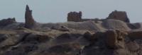
Ancient settlement of Gyaur kala (Khojeli).

Tours and excursions in Karakalpakstan.
“In a moment, an instant - and life flashes by...
Let this moment shine with fun!
Beware, for life is the essence of creation
How you carry it out, so it will pass”
Omar Khayyam.
Excursions to monuments of Karakalpakstan.
The ancient settlement of Gyaur kala (Khojeli) is located on a natural hill 104.6 meters above sea level, 5.6 kilometers to the west and slightly south of the city of Khojeyli, 1.3 kilometers northwest of the Mizdakhan necropolis in the Khojeli region of the Republic Karakalpakstan.
The flat top of the western hill is crowned with the majestic ruins of the ancient fortress of Guyar Kala. The settlement occupies the entire flat top of the hill. A fortress wall with ten defensive towers encircles the top of the hill along its edge.
Inside the fortress walls, the remains of two citadels of different times - eastern and western - have been preserved. The entire area of the settlement is dissected by mounds of ancient buildings. The western wall has been preserved to a height of 10 meters.
From the facade, the plane of the walls was divided by vertical half-columns-corrugations. The suite of cultural strata of the Gyaur Kala settlement reaches a thickness of 10 meters and covers the period from the IVth century BC. until the beginning of the XIIIth century A.D.
The ruins of Gyaur Kala located on top are dated to the IXth - early XIIIth centuries. On the flat saline plain to the west of the hills are the ruins of an unfortified XIIIth - XIVth century town covering an area of about 80 hectares.
On the surface, layouts of buildings, quarters and city streets appear everywhere. Between the buildings, in a number of places, traces of ancient canals, which are simultaneous to the city, have been recorded. On the eastern edge of the city, at the foot of the eastern hill, there is a large group of ruins of pottery kilns - the remains of the potters' quarter.
To the east and southeast of the hills, flat salt marshes and takyrs, strewn with fragments of separate sections of ancient main and distribution canals, stretch at a distance of up to 1.5 kilometers. Irrigation layouts traced in a number of places suggested that takyrs and salt marshes are the remains of ancient fields plowed at a later time.
Here, in a number of places, low, swollen mounds of detached buildings have been preserved.
Geographic coordinates of the ancient settlement of Gyaur Kala (Khojeli): N42 ° 23'36.69 "E59 ° 2'39.71"

Literature:
1. Grazhdankina NS "Building materials for the mausoleums of Mizdahkan". Architectural heritage of Uzbekistan, Tashkent, 1960.
2. Esbergenov H.E., Yagodin V.N. "Some results of the study of Mazara Shamun-nabi." VKK FAN UzSSR, No. 4, 1966.
3. Nekrasov A.A. "Inscriptions on the gravestones of the Mazlumkhan-Slu mausoleum in Mizdahkan." ZKV, vol. U, L. 1930.
4. Pilyavsky V.I. Urgench, "Mizdahkan". M. 1948.
5. Filimonov V.M. "Mazlum-Slu Palace, a unique monument of civil architecture." In the collection: Materials and research on the history and restoration of architectural monuments in Uzbekistan. Issue 1,
ashkent, 1967.
6. Yagodin V.N. "New data on the history of the religion of Khorezm." SE, No. 4, 1963.
7. Yagodin V.N. "To the study of the chronology and topography of the ancient Mizdahkan." In the collection “History, archeology and ethnography of Central Asia”. M. 1968.
8. Yagodin V.N., Khodzhayov T.K. "The necropolis of the ancient Mizdahkan". Tashkent, 1970.
9. Yakubovsky A.Yu. "Mizdahkan Settlement". EKV, vol. U, L. 1930.
Photos by
Alexander Petrov.