


![]()
You are here
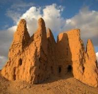
Ancient settlement Kavat kala.
Tourist routes in Karakalpakstan
“We take the direction to the south, to the ruins of the dead oasis of Kavat-kala. We walk along the canal, which is clearly visible against the background of the salt marsh, stretching along the edge of the dry lake. The landscape is changing. Below us is the grayish-white space of takyrs, covered with countless crescent dunes. Between them are the grandiose ruins of the city of Kavat-Kala with its system of double towers, and around dozens of castles and peasant estates located on numerous branches of the canal, covering the takyrs with a dense network. The entire original architectural ensemble of the vast “rustak” of the era of the “great Khorezmshs” is in full view. If it weren't for the sands, it would seem like an architectural model."
Tolstov S.P. “In the footsteps of the ancient Khorezm civilization. Part 1"
Tourism in Karakalpakstan.
The Kavat Kala settlement is located in the eastern part of Lake Akhchakol, in the southern part of the Kavatkala village and in the northern part of the Bustan village, 3.4 kilometers northwest of the Ellikkala village in the Ellikala region of the Republic of Karakalpakstan.
The vicinity of the ruins of the Kavat Kala fortress is a magnificently preserved monument of this era. This is a whole dead oasis, spectacular ruins of a whole “rustak”, stretching from the ruins of Djildik Kala to Kavat Kala and further north for about a third of the distance between Kavat Kala and Toprak Kala.
Stretching for 15 kilometers along the dry channel of the Gavkhore, a strip of takyrs 2 - 3 kilometers wide, completely covered with countless ruins of fortresses, castles and unfortified peasant estates, scattered among the perfectly preserved layouts of medieval fields, outlined by strips of distribution and irrigation canals.
We have registered over 90 peasant estates on the 8 square kilometer strip directly adjacent to Kavat Kala. If we compare the population density of the Rustak fortress of Kavat Kala with the Afrigid rustak Berkut Kala, where about 100 farmsteads are located on an area of 35 square kilometers, then we will see that the population density has increased by about four times.
Geographic coordinates of the Kavat Kala ancient settlement: N41 ° 51'15.45 "E60 ° 54'39.55"
Authority:
http://xorazmiy.uz/oz/pages/view/175
Alexander Petrov.
Photos by
Alexander Petrov.