


![]()
You are here
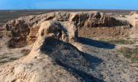
Ancient settlement of Maytobe.
Best New Shymkent Tours.
“Ancient aphorisms outlived centuries. Modern aphorisms can barеly survive from book to book”
Ljupka Cvetanova.
Tourism in Shymkent.
The ancient settlement of Maitobe dates from the XIth - XVIth centuries, it is located on the northern outskirts of the village of Zhartytobe on the left bank of an anonymous dried source of spring origin in the Sozak district of Turkestan region.
Openly and surveyed by the South Kazakhstan Archaeological Expedition (E.I. Ageeva) in 1953. Re-examination and reconnaissance excavations were carried out by the archaeological detachment of Shymkent Pedagogical Institute (N.P. Podushkin) in 1980.
The topography of the monument: a fortification with two divisions. It consists of a central hillock, rectangular in plan, stretching from east to west (the citadel), with a base size of 100 x 110 meters, the upper part - 40 x 45 meters and a height of 8 - 10 meters.
The citadel is bordered by ditches up to 20 meters wide on the north, west and south sides, the east side is facing the channel. The fortress walls in the form of a swollen shaft up to 2.5 meters high, envelop the central hillock along the contour of the ditches, an opening (entrance gate) is marked in the northern part of the shaft.
From the south to the citadel adjoins a platform measuring 80 x 90 m and a height of 3 meters. In general, the settlement is stretched from north to south, has the steepest eastern slopes (up to 40`). The reconnaissance excavation included the area of the central building, rectangular in plan, measuring 15 x 13 meters, the walls of which are made of raw brick 40 x 20 x 11 cm.
Finger grooves are fixed on some bricks. Residential structures of the upper construction horizon are uncovered at a depth of 0.9 - 1 meter from the level of the surface. As a result, square (rectangular) premises from the dog-brew were found, in each of which 1 - 2 tandoor with a diameter of 0.8 - 0.9 meters, with notches on the walls, cesspools recessed into the floor, rounded in plan; stone calculations at floor level; numerous fragments of ceramics, stone products.
Archaeological material includes fragments and reconstructable forms of vessels for household, kitchen and table purposes (irrigation, non-irrigation), stone scaphoid grains, pestles, springs, which, by analogy with material from nearby monuments (ancient settlements of Suzak, Kultobe, Ran, Kumkent) date back to XV - XVI century
Geographic coordinates N 43` 35.678`: E 069` 14.328`
Authority:
D. A. Taleev. "Code of monuments of the South Kazakhstan region." Architectural and archaeological heritage of the South Kazakhstan region. In the framework of the regional program "Cultural Heritage". http://www.farsah.kz
Photos
Alexander Petrov.