


![]()
You are here
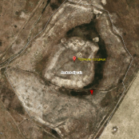
Ancient settlement Tortkol-Karachuk.
Tourist walk in Turkestan.
"The first rule of history is not to allow lies"
Alisher Navoi.
VIP walk across South Kazakhstan.
Ancient settlement Tortkol-II is located on a natural hill 224.4 m. a. s. l., 747 meters on the right bank (northern) of the Karyshyk River, 10.7 kilometers northeast of the city of Turkestan, 7.9 kilometers southwest of the village of Zhuinek and 6.7 kilometers to the east and slightly north of the village of Kumtiym (formerly Karashyk), subordinate to the city administration of Kentau in the Turkestan region.
(Tortkol-1 and Tortkol-2), the remains of the medieval settlement of Karachuk (XVI-XVIII centuries). The mentions of Karachuk are found in written sources from the XIth to the XVIIIth centuries. According to some sources, in the XVIIth century Karachuk was on the caravan road near Turkestan.
Tortkol-2 corresponds to Karachuk of the pre-Mongol period (VI-early XIII centuries), Tortkol-1 is a city of the late Middle Ages (XIII-XVIII centuries). The fortified settlements Tortkol I and Tortkol II - the city of Shavgar-Karachuk are confidently identified with the settlement of Tortkol I on the Karashyk River, while the late medieval Karachuk corresponds to the settlement of Tortkol II, located on the left bank of the Karachik River.
Excavations at the citadel of the Tortkol I settlement showed that the upper layer of the XIIIth-XIVth centuries contains residential buildings, and below it is supposed to find a monumental structure of the Xth-XIIth centuries. The fact that the town, localized on the site of the settlement of Tortkol I, actively lived in the X-XIII centuries, is evidenced by lifting material: numerous finds of glazed ceramics, glass, metal products.
The location of the Tortkol I monument, the topography, the nature of the lifting material and the toponymy data testify in favor of its identification with the medieval Shavgar, late Karachuk. Therefore, Mahmud Kashgar also points to the earlier name of Karachuk - Farab, which was at one time a component of the Tarband district, which united both Farab and Shavgar.
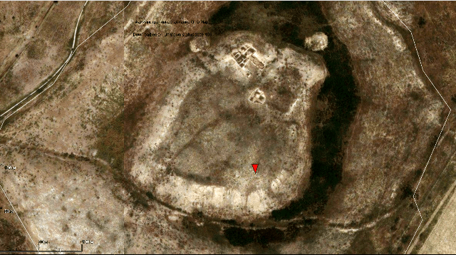
The ancient settlement Tortkol II (Karachik) dates back to the XIIIth-XVIIIth centuries. In plan, a sub-rectangular hillock, 180 x 120 meters in size, 5 meters high. In the northern part there is a sub-rectangular hillock 8 meters high - the remains of a citadel.
The citadel is walled on all sides with well-traced towers at the corners. Shakhristan is also surrounded by a wall. At the corners of the wall along the perimeter there were towers, from which there were hillocks 1 - 1.5 meters high above the general surface of the settlement.
A ditch in the form of a wide hollow can be traced around. The central ruins are adjoined by an area with traces of development, surrounded by a wall with towers. In 2016, in order to study the fortification in the eastern part of the settlement, a stratigraphic trench was laid to cut the proposed fortress wall.
The top-down stratigraphic section consists of the following layers:
Light yellow loam, loose.
Combustion layer - the thickness of the layer of ash and soot is 30 - 35 cm.
A dense layer of loam with inclusions of white carbonate 16 - 22 cm thick.
Dense loamy layer mixed with ash. Layer thickness 10 - 30 cm.
A layer of red-brown color with traces of calcination. The layer thickness is 10 - 17 cm.
The foundation of the wall is made of river pebbles.
A layer of ash and charcoal 60 cm thick.
Ash lens layer 20 - 30 cm thick.
A layer of organic matter (rotted manure) 35 cm thick.
A layer of black (soot) 15 cm thick.
The layer is dark brown.
Pakhsovaya wall 85 - 120 cm thick.
The excavations revealed the absence of an external wall.
Findings. As a result of the study in the field season of 2016 of the fortification of four settlements of the Otrar oasis and one settlement of the Turkestan oasis:
The outrigger tower of the Kuik-Mardan settlement - donjon was studied, in which 12 rooms were identified.
Excavations of the fortress wall at the Kuiriktobe settlement were carried out, where the fortification system was investigated.
The fortress wall of the shakhristan of the Altyntobe settlement was investigated.
A stratigraphic section was made at the settlement of Tortkoltobe II (Karachik), which showed that the late medieval settlement did not have an external defensive wall.
Geographic coordinates of settlement of Tortkol-II: N43°22'50 E68°12'17
Authority:
K.M. Baypakov, D.A. Voyakin, I.R. Kamaldinov.
"Research of fortification on the settlements of Otrartobe, Kuik Mardan, Kuyryktobe, Altyntobe and Tortkoltobe-Karachik in 2016".
Institute of Archeology named after OH. Margulan, Almaty, Kazakhstan
Alexander Petrov.