


![]()
You are here
Ancient settlements of Talas Valley.
Cultural tours in Zhambyl region.
“Atlah is a large city, in size close to the capital (to Taraz or Isfidjab); has walls. Most of the city is made up of gardens; in its rural surroundings, grapes are most cultivated. The cathedral mosque is located inside the city, bazaars are in the suburbs"
Arab geographer and historian Masudi (Mas-udi Abulhasan Ali). "Muraujuz-Za-khab wa Ma dinuljauhar" ("The Book of Golden Meadows and Mines of Precious Stones").
Holy places of Zhambyl region.
Mentions of the towns of the Talas Valley - Talas, Yangi-Talas, Kenzhek - are found in the author of the mid-XIVth century al-Omari. Apparently, the role of the capital of the Talas Valley at that time passed to the town of Yangi Talas, located in the upper part of the Talas River.
As the town of Talas ceased to exist at the beginning of the XVth century, a settled settlement at this place continued to exist until the XVIIIth century. Taraz position on the Great Silk Road made it the main city of the Talas Valley - a huge agricultural region adjacent to the caravan road.
The Silk Road from Ispidzhab to Taraz passed through such points as Sharab, Budukhket, Tamdaj. Abarjaj and Juvikat. Excavations in the Talas Valley shed light on the existence here during the VIth - XIIth centuries. “Town of Juvikat. It defended from Taraz by two farsakhs (14 - 16 kilometers) to the west.
The location of Juvikat is established precisely: this is the Bektobe settlement, located 17 kilometers east of the ancient settlement of Taraz, which corresponds to two farces between the cities indicated by the sources.
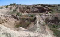
Bektobe settlement is located on the southern slopes of the Ulken Burultai ridge. The central part of the settlement is a rectangular (100 x 120 meters) hillock 5 - 7 meters high, along the edge of which there is a wall with towers at the corners and perimeter.
In the northwestern corner there was a citadel in the form of an oval hillock (its dimensions at the base are 30 x 20 meters) with a platform at the top (20 x 15 meters). The central ruins are adjoined by a territory enclosed by a long wall.
There was an agricultural district here. Assignment of the Bektobe settlement to the VIth - XIIth centuries corresponds to the lifetime of the city of Juvikat and confirms their identity. One of the major cities of the valley was Atlah, al-Maqdisi described it as follows: “Atlah is a large city, it approaches the main city in area, with a wall around it. Most of it is orchards, and vineyards prevail in rustak. The cathedral mosque is in medica, and the markets are in rabad."
Atlah is identified with the ancient settlement Juvantobe, located 12 kilometers south of the ancient settlement of Taraz. This distance is confirmed by the message of Mahmud Kashgar, who noted: "Atlah is the name of a town near Taraz."
The town of Atlah became widely known in history as the place near which the Talas battle took place - between the Chinese troops and the united forces of Arabs and Karluks. The latter defeated the Chinese army, its prisoners were sent to Samarkand, where they were engaged in crafts: making paper, various weapons and tools.
The materials of archaeological research in recent years have confirmed the identity of Atlah - with Juvantobe. It was also established that Juvantobe, the largest settlement in the Talas Valley, dates back to the VIth - XIIth centuries.
The city of Jikil (Chigil) is mentioned in the list of cities as a sedentary agricultural region and is described as “a small city at the distance of a human voice from Taraz: there is a wall around it, and it has a citadel. The Cathedral Mosque is on the market.
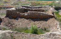
The city also existed in the XI century. and is mentioned by Mahmud of Kashgar. Djikil most likely corresponds to the settlement of Zhalpaktobe, located 5 kilometers from the settlement of Taraz. The ancient settlement Zhalpaktobe is a sub-rectangular hill with dimensions at the base of 90 - 95 meters and a height of 3 - 4 meters.
In the eastern part there was a citadel preserved as a hill 4.5 meters high and 30 meters in diameter. Around the hill, traces of a ditch 0.5 meters deep and 10 meters wide are still visible. The central entrance to the settlement was in the middle of the southern wall.
At present it looks like a hollow and is flanked on both sides by two rounded towers. Investigations in 1996 revealed a wall at a distance of 1 - 1.5 kilometers from the central ruins. Excavations on the territory of the settlement revealed the nature of the development at the level of the 6th-9th centuries, which was continuous: all the premises were attached to one another.
Inside living quarters, on floor, open-type hearths are typical and along the walls - sufa. The walls are built of mud bricks and set on a cobblestone foundation. In the pantry-rooms, grain pits were arranged. The ceramics of the Zhalpaktobe settlement is represented by circles decorated with floral carved ornaments, cauldrons with arcuate and segmental handles, clay and alabaster round tables-dastarkhan, lamps.
The Turgesh coins found here allow dating the complex to the VIIth - IXth centuries. As for the upper building horizon, judging by the presence of fragments of glazed ceramics, the buildings of this layer belonged to the X - XII centuries.
Excavations made it possible to find out the nature of the fortification of the city. The walls have survived to a height of 4 meters. At the base, their width was 5 meters, upward they narrowed. Lakh blocks (80 x 80 x 60 cm) were laid at the base of the walls; adobe bricks (35 x 25 cm) were laid on them.
Round towers were located at the corners of the walls. The northern wall had a berm - a ledge 4 meters wide. Also not far from Taraz were the cities of Deh Nudjikes and Adahket, the location of which allows us to determine the preserved information of Ibn Khordadbeh and Qudama.
Describing the road to the Kimaks, they mention two villages in the Kevaket (Kevakib) locality, 7 farshs from Taraz. Even more specific is al-Fakih, the author of the 9th century, who indicates the distance from Taraz to Kevakib at 7 farsahs.
Another important detail is that the path to the Kimaks went to the left of Taraz, that is, to the north. Since the most convenient way from Taraz to the north passed along the banks of Talas, in its valley one should look for the Kevaket (Kevakib) area with two cities.
Studies show that the largest medieval settlements to the north of Taraz are Toimakent and Okhkhum. Moreover, the distance between Taraz and the settlements is 50 - 55 kilometers, which coincides with the data of the sources.
Adahket, which was closer to Taraz, can be identified with the Toimakent settlement, and Deh Nujikes - with Ohhum. However, there is another opinion, confirmed by new archaeological materials. Adahket and Deh Nudjnkes can be localized 30 kilometers north-east of present-day Taraz, in the Assa valley, at the site of the Karakenir settlement.
The study of aerial photographs, combined with visual research, allowed the discovery of a long wall around two settlements - Karakenir-I and Karakenir-II, which once limited the agricultural district. Consequently, an assumption arises about the existence of a kind of oasis, which can be identified with the Kewahib area, then the cities of Deh Nujikes and Adahket correspond to two settlements - Karakenir-I and Karakenir-II.
To the south of Taraz were the cities of Sheldzhi, Sus, Kul and Tokabet. Shelji is the most famous of them. There were 4 farsakh ways between Taraz and Sheldzhi. Researchers unanimously locate Sheldzhi on the site of the settlement of Sadyr-Zhurgan, located 30 km south of modern Taraz.
It is known about the city of Sousse that it was “a big city, and Kul was smaller than it”, “Tekabet is a big city, half of it are infidels. The location of the city near the mountains with silver mines. It is possible to quite confidently identify the above-described cities with forts: Aktobe Orlovskoe - with Kul, Aktobe near Talas - with Tekabet, Chaldovar - with Sous.
For the first time Mahmud Kashgar speaks about the city of Kenjak: "Ksnd-zhak-Sengir is a city near Taraz." In the XIII century, it continued to exist under the name Kenjak. Sources say: “Yangi is four cities. Between each of them and the other one farces, each city has its own name.
One is Yangi, the other is Yangi-Balyk, the third is Kenjak. the last one is Taraz. Have the author of the first half of the XVth century, Arabshah, named the city of Yangi-Talas, located four days' journey from Islijab.
In the description of Rubruk's travel in 1253, there is a mention of the city of Kinchat, in which it is easy to recognize the name Kenjak. After crossing Karatau, Rubruzh wrote: “... On the seventh day to the south of us there were very high mountains, and we went to the plain, which was irrigated like a garden, and found cultivated land... We entered the Saracen city on. named Kinchat... And a large river descended from the mountains, which irrigated the whole country... this river did not flow into any sea, but was absorbed by the earth, forming many swamps there... The next day we arrived at another village, more close to the mountains... I asked about the city of Talas, in which there were Germans - slaves of the Storm”.
Judging by the passage, Kinchat was in the lower reaches of the Talas. Here we know two settlements corresponding to the layers of the XIII - XIV centuries, one - Sharvashlyk, the other - Okhhum. In our opinion. Ki-chat is identified with the settlement Sharvashlyk, and the settlement of Okhhum was exactly the village that Rubruk reached "the next day."
The literature suggests that the names "Yangi-Talas - Yangi-Balyk" refer to the same city, which corresponds to the settlement of Sadyr-Kurgan. However, sources say nevertheless, about four cities, of which Talas corresponds to Taraz, and Cayd zhak corresponds to Shashvashlyk. Yaigi-Balyk and Yangi (or Yangi-Talas) should be compared with settlements where there would be late medieval layers.
Such monuments are Sadyr Zhurgan and Aktobe near Talas. Moreover, the latter corresponds to the city, which was the new political center of the valley, judging by the remarkable architectural monument of the XIV century "Gumbez Manas" preserved here.
This version also resonates with the information of Ibn-Arabshah that under Timur the Naib was appointed in Yangi-Talas. Thus, Yangi-Talas, apparently, should correspond to the settlement of Aktobe, and Yaigi-Balyk - to Sadyr-Kurgan.
To the north-west of Taraz were the cities of Khutukhnn and Beruket. The first has been known since the Xth century. Beruket is referred to as "Pergant" in the description of the route of the middle of the 13th century by the Armenian king Getum.
Leaving Taraz, Getum drove through Khetukhchin, Pergant and went to Sugul Khan. Khutukhchii and Beruket (Pergant) were located on the site of the settlements of Mai-tobe and Tamdy, located on the ancient caravan route from Taraz to the cities on the northern slopes of Karatau.
It ran near Lake Biili-Kul towards modern Baikadam, where Sugul Khan is located. Sources call the Lower Barskhan the next on the Silk Road in the direction to the east. According to the description of the route of Ibn-Khordadbeh and Qudama.
Nizhny Barskhan was three farces from Taraz. It is said about him: “Barskhan is a town at a distance of two human voices from Taraz to the east, around it is a wall that has already collapsed. Cathedral mosque among the markets”.
Lower Barskhan is identified in the settlement of Tortkultobe. located at a distance of about 15 kilometers from the ruins of Taraz (now - at the Talas railway station). Aerial photography revealed its topography. The settlement looks like a two-tiered hillock, rectangular in plan, oriented by the sides along the cardinal points.
The size of the hillock at the base is 140 x 140 meters, the height is 4 - 5 meters. The northwestern corner is occupied by a hillock-shaped citadel (30 x 30 meters), 10 meters high. Shakhristan is surrounded on all sides by a swollen rampart with hillocks in place of towers at the corners and perimeter.
The highest wall, 8 meters, is the northern one, adjacent to the citadel. Entrances to the territory of shahristan, and there are two of them, are traced from the east and west sides. They are flanked by towers. From the side of the entrances to the settlement adjoin the sites - eastern (70 x 70 meters) and western (100 x 100 meters).
These are the remains of a rabad, here you can see the depressions - the remains of the Khauz. To the east of the settlement, buildings were traced in the form of separate hillocks - these are the remains of estates that were part of its agricultural district: the decoding of aerial photographs from large-scale maps made it possible to identify around the central ruins the remains of a long wall that surrounded the territory - it recedes from the central ruins by 1.5 - 2 kilometers.
Thanks to the splits in the citadel, it was possible to trace a group of rooms, rectangular and square in plan. Floor hearths and stone pavements were cleared in the fields. In one of the rooms there was a platform with dimensions of 2.5 x 3.7 meters made of pink kir (alabaster).
Near the site there was a hum, 1 meter high and 70 cm in diameter, dug into the ground. The structure, as it was possible to establish, is the remains of a winery.
Authority:
K.M. Baypakov. “Medieval settlements on the Great Silk Road”. Almaty, "Gylym". 1998.
Photos by
Alexander Petrov.