


![]()
You are here
Arheological monuments Akmola region.
Cultural tourism in Astana.
“He who conquers himself is the mightiest warrior”
Confucius.
Tours Astana and Turkestan.
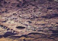
Following the logics of the interaction of social systems and the environment, archaeological sites and their study took place in the most convenient places for people: on the riverbanks, near the springs, in the terraces of the rivers where the settlements belonging to the period from Mesolithic era to the Bronze Age had been revealed and studied.
The sites are also concentrated in the areas near the rivers and ancient valleys. Here separate mound groups were revealed, as well as stone structures in the form of fences belonging to the Bronze Age, Early Iron Age and the Middle Ages.
Archaeological sites are grouped unevenly. And it depends on the availability of favourable conditions for living at a certain period of time (availability of fresh water, rich flora and fauna). The valley of Chaglinka River and its right tributary, Koshkarbai River (from Karsak village to Aidarly village) is a unique region with regard to geographical conditions and with regard to history and culture.
This territory was inhabited by men already in Mesolithic-Neolithic era, i.e. around 10 thousand years ago and maybe even earlier. Availability of various and occurring at different times archaeological monuments speak about the impetuous historical past and large population density.
Here are the burial grounds, settlements and sites dated as of the Mesolithic age and the Middle Ages. Total number of burial grounds and burial mounds constitutes at least 300, and the number of settlements and sites is at least 20.
Therefore this region was always of interest to archaeologists. From the times of the creation of the Archaeological Map of Kazakhstan (1956) regular archeological groups are working here: Akishev, 1956; Zaibert, 1987; 2006.
There were some stationary excavations: burial ground Koshkarbai I, 1973; settlement Kenotkel VIII, IX, X, 1978-1979; settlement and burial ground Pavlovka, 1983, 2005; site Kenotkel XXI, 2005. All this date says that the region has great history.
That is why its further study will have great significance and will provide a lot of materials for historical reconstructions. Besides, many monuments are in the deteriorated state either because of the influence of natural factors (every year burial grounds Koshkarbai I, Kenotkel XIX get destroyed by the storm-water and now many burial grounds can be found with great difficulty), or because of the people’s activity (there are high-voltage electrical cables going through settlement Koshkarbai II; burial grounds Koshkarbai I, Kenotkel XIX, Troitskoye II are destroyed by the field roads, and burial ground Koshkarbai IV is destroyed during the construction of the road connecting Aidarly village and Koshkarbai village; burial ground Kenotkel XVIII was ploughed up in the Soviet times, and there is also a problem that livestock can be pastured everywhere).
All this leads to the situation when every year we lose newly found unique monuments.
Authority:
http://www.kazakhstan-tourist.isd.kz