


![]()
You are here
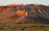
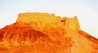
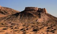
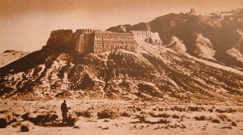
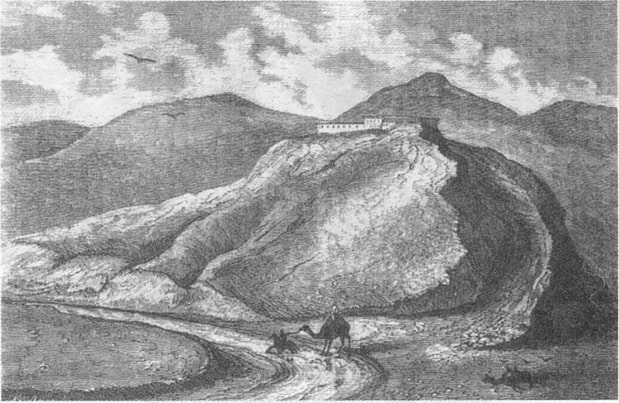
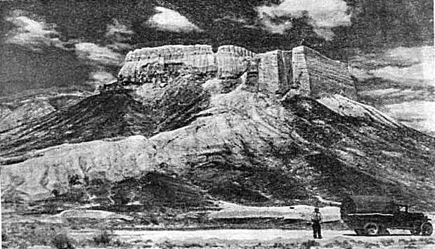
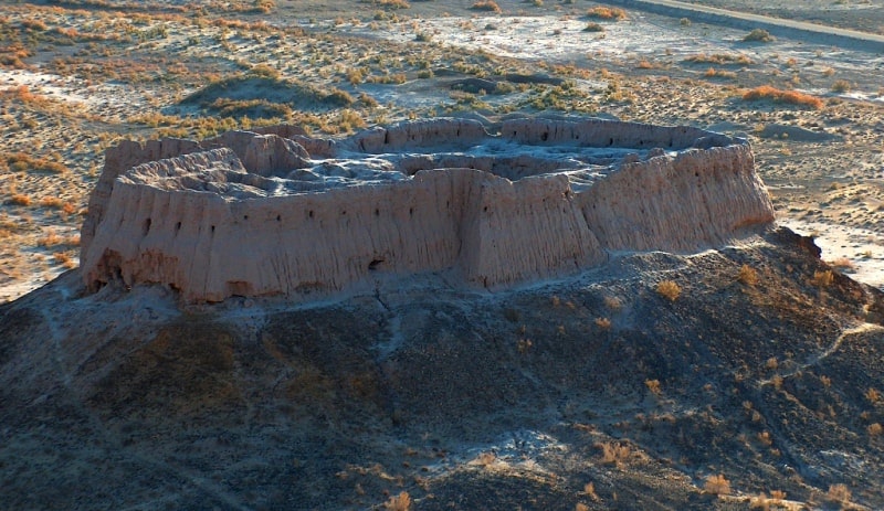
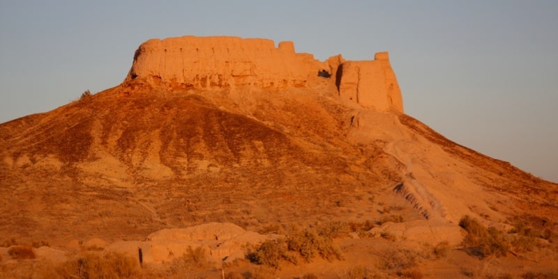
Ayaz kala (Small) in Karakalpakstan.
Destinations and routes to Karakalpakstan.
“My homeland is known to the whole world.
For many years, many have chanted it.
And I also want to sing his glory,
For I am the son of Khorezm, the son of Khorezm..."
Uzbek poet Erkin Samandar.
Guide to sights of Karkalpakstan.
The settlement Ayaz kala No. 2 (Small) is located on a natural hill, located in the southern part of the Ayazkol salt marsh and in the waste part of the Pashakhaikum sands, at the eastern end of the Sultan-Uvais ridge, 20.5 kilometers north and slightly east of the village of Bustan, 19 , 5 kilometers north and slightly west of the Shark-Yulduzi village, 19.4 kilometers north-west of the Dzhambaskala village and 42.3 kilometers north-east of the city of Beruni in the Ellikala region of the Republic of Karakalpakstan.
The site was surveyed in 1939 by S.P. Tolstov and dated to the first centuries A.D. Excavations were carried out in 1971. The monument was erected on the top of a natural conical hill about 30 meters high above the level of adjacent takyrs and has a complex configuration in terms of plan.
Its northern and southern walls are parallel. the eastern part has a semi-oval shape. The western part is rounded in such a way that the north-western corner protrudes slightly. The main part of the settlement has dimensions in diameter from south to north 36 meters, from west to east - 65 meters.
An entrance complex is attached to the main castle on the south side. It juts south for about 20 meters and is 31 meters long. The lower part of the walls with a height of 3.35 - 3.85 meters was built of pakhsa. The top of the walls was built of adobe bricks measuring 37 - 37 x 37 - 38 x 8 - 9 cm.
The slope of the lower part of the walls to the base is 85 °. The upper part of the oval castle is decorated with semi-columns along the entire perimeter. They protrude from the wall plane by 0.40 - 0.45 meters. The length of the half-columns along the facade is 1.55 - 1.60 meters.
They have been preserved in height from 2.4 to 3.7 meters. The surface of each half-column is decorated with five false loopholes. The top of the half-columns has not survived. At the base of the half-columns, rectangular loopholes are cut along the entire perimeter of the walls.
They are located every two semi-columns. Their width is 0.18 meters. The height of the inlets is about 0.85 meters. The slope of the loophole bottom is 35 °. The bottom of the entrance is 0.78 - 0.80 meters above the floor of the shooting corridor.
Half of the loophole opening into the shooting corridor has a flat stepped roof made of adobe bricks. Overlapping the rest of the loophole parallel to its bottom. A shooting corridor with a width of 2.32 meters runs along the outer wall of the fortress.
The width of its inner wall is 1.23 meters. In the middle of the western part of the settlement, at the highest point of the hillock, there is a depression of a rounded shape with a diameter of about 15 meters and a depth of 3.3 meters.
The edges of this depression in the lower part are outcrops of sandstone with ferruginous corrections. From the mainland to the floor level, as it was found out by two pits, there is a masonry up to 2.7 meters thick, made of raw brick 38 - 40 x 38 - 40 x 8 - 10 cm in size, sprinkled with sand.
The thickness of the bookmark, with the help of which the slopes of the hill were leveled, increases towards the walls of the castle. The leveling of the slopes of the hill was necessary for the construction of a small castle on its top.
Excavations revealed that, apparently, the entire area of the castle was built up with relatively narrow, corridor-like rooms. The ceilings were probably vaulted. The walls are up to 0.7 meters thick. They have survived to a height of no more than 0.7 meters.
The cultivated layer of the floor consists of a soft golden mass in the lower part and a layer of manure. The corridors and living quarters end in a recess in the center of the castle, indicating its later origins. 6.4 meters east of the bend on the north wall, there is an arched opening 2 meters wide, traced for 3.5 meters.
The vault was erected from trapezoidal bricks. The entrance complex of rectangular outlines adjoins the southern wall of the castle. Its eastern wall has 9 flat, covered loopholes, located at a distance of 0.88 to 1.8 meters. The width of the inlets is 0.11 - 0.19 meters.
Their height is 0.97 - 1.10 meters. The angle of incidence is 300. Some of the loopholes have the same height of inlet and outlet openings. An open 1.25 meter wide valgang runs along the eastern wall. The western part looks like a tower placed 8 meters away.
The entrance complex is a gateway structure. On the western slope, the remains of a ramp with a length of 50 - 55 meters have been preserved. The width of the carriageway is 2 meters, the total width is 3.1 meters. The slope of the ramp is 15 - 200.
The eastern end of the ramp approaches the rectangular towers measuring 9 x 8 meters. It is 5 - 6 meters away from the western wall of the entrance complex. A portable tower with an entrance complex using a swing bridge.
Ceramic material is represented by pottery and stucco vessels dating from the second half of the VIIth - first half of the VIIIth centuries. In the XIIth - early XIIIth centuries, 6 rooms were built along the northern wall. In the entrance of the complex, the upper part of the southern wall and western tower is built up from mud bricks measuring 26 x 26 x 4-5 cm to a height of 3.3 meters.
The entire layout in the southeast corner is covered with continental sand taken from a pit in the center of the castle. Several rooms were built in the western part of the entrance complex.
Geographic coordinates of the settlement Ayaz kala №2 (Malaya): N42 ° 00'39.30 "E61 ° 01'38.09"
Literature:
1. Gulyamov Ya.G. "The history of irrigation in Khorezm from ancient times to the present day" Tashkent, 1957.
2. Manylov Yu.P. "Archaeological monuments of Sultanuizdag of the era of antiquity and the Middle Ages." AKD, Tashkent, 1972.
3. Manylov Yu.P., Khozhaniyazov G. "The settlements of Ayaz-kala I and Burly-kala, to the study of the fortification of ancient Khorezm." On Sat. Archaeological research in Karakalpakstan.
Tashkent, 1981.
4. Terenozhkin A.I. "Archaeological exploration in Khorezm." CA No. 6, 1940.
5. Tolstov S.P. "Antiquities of Upper Khorezm". VDI, No. 1, 1941.
6. Tolstov S.P. "Ancient Khorezm". M., 1948
Photos by
Alexander Petrov.