


![]()
You are here
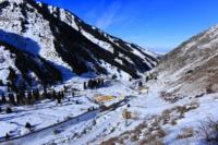
Big Almaty dam.
Tours Kazakhstan.
“The sparkling, immaculate whiteness of the alpine snows, untouched, or perhaps unattainable; the beauty of the mountains, covered with a misty haze, because of which you cannot distinguish whether it is the earth or a cloud; distant, clear, passionless mountains - all this symbolizes the highest aspirations of the spirit. The universe appears to people in all its glory and greatness, they are seized with anxiety, the craving for adventure, characteristic of their ancestors, wakes up in them, and they leave ... It is not at all a conscious choice that makes people change comfort and safety for adventure and adversity - most likely, it works here an impulse deeper and stronger than consciousness and reason"
Rockwell Kent.
Tours Almaty.
The Big Almaty Dam is located at an altitude of 1280 m. a. s. l., located in the bed of the river of the same name, 6.7 kilometers southeast from the corner of Al-Farabi \ Navoi streets, in the Bostandyk district of Almaty.
The dam is an artificial anti-mudflow structure in the valley of the Bolshaya Almatinka River, erected at its exit from the mountain. Serves to stop mudflows and floods that threaten the western part of the city of Almaty. The construction of the dam, which was carried out according to the project of the Kazakhakh branch of the Institute "Hydroproject" named after S. Ya. Zhuk, since 1976, was completed in 1980.
The height of the structure is 40 meters, the total length along the ridge is 422 meters, including the blind part - 282 meters and the mudflow part - 140 meters. The blank part is an earthen embankment of boulders and pebble soil, on the crest of which there is a reinforced concrete retaining wall.
The mudflow discharge, designed to remove excess volumes of mudflow in case of overflow of the mudflow storage, is combined from an upper gravel and pebble slope and a downstream large cellular reinforced concrete dam. The capacity of the created mudflow storage facility (8.2 million cubic meters is designed for the maximum possible catastrophic mudflow of storm or glacial type, the probability of which is 1 time in 10,000 years.
As the mudflow storage is filled, its capacity will be restored by cleaning the headwater or building a dam. To extend the service life of the mudflow storage, a set of measures is being carried out, including the preliminary discharge of water from mudflow lakes in the valley of Big Almaty, building up the dam of Big Almaty Lake, stabilizing river channels with through reinforced concrete structures, forest reclamation of slopes, etc.
The dam kept a catastrophic mudflow that threatened the city 3 August 1977 Mud splashed out from the right tributary of the Big Almaty - the Kumbel-Su River. In August 1977, a catastrophic mudflow took place in the gorge, which was delayed by a dam built in the riverbed.
Until 1977, it was a well-maintained, flat, partially improved, rocky road, convenient for driving. On August 3, 1977, a mudflow blew everything down, destroyed the road and bridges and filled up with boulders and pebbles.
Geographic coordinates of dam in Big Almaty Gorge: N43°08'10 E76°54'16
Authority:
Brief Encyclopedia of the Kazakh SSR, volume 2, Nature, Alma-Ata, 1990.
Photos by:
Alexander Petrov.