


![]()
You are here
Bottom of Khvalyn Sea.

Sightseeing tours in Kazakhstan.
“The sea is a great reconciler”
F. Iskander.
Traveling in Atyrau region.
South of the city of Uralsk, the Urals enter the Caspian lowland, which is a deep tectonic basin with sharp manifestations of salt-dome tectonics. The lowland decreases towards the Caspian Sea and has absolute marks from 50 meters at the foot of the Presyrtovoy ledge to -28 meters on the sea coast.
The surface of the Caspian lowland is composed of marine and continental clays and sands, less often pebbles and loams. The geological territory of the Caspian lowland is very young. During the Quaternary period, it was repeatedly flooded as a result of transgressions of the Caspian Sea.
The largest offensive of the sea occurred about 20 thousand years ago at the beginning of the Late Pleistocene, between the ice ages on the Russian Plain. As the ice cover melted, the level of the oceans increased. At the same time, the outskirts of the Russian Plain were plunging.
The Caspian, or Khvalynskoye, sea penetrated far to the north, flooding the entire Caspian lowland. Sea waters entered the Volga above the place of its confluence with Kama, and along the Ural valley rose to the mouths of Uva, Irtek and Kindeli.
The coastline of the ancient Khvalynsk Sea is preserved in the form of a ledge not only in the river valleys, but also on the interfluve. It can be clearly seen along the northern side of the Caspian lowland between the Volga and the Urals, as well as between the Urals and Emba.
This ledge is clearly visible on terrain maps approximately horizontally 50 meters above sea level. By the beginning of the last, Valdai glaciation, the Khvalynsk Sea had left the Northern Caspian. And it went quickly, leaving behind a 40-meter ledge.
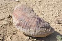
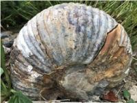
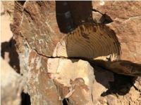
As a result of this, mass extinction of marine animals occurred, as evidenced by the accumulation of shells of marine mollusks in the upper sandy loam of the Khvalyn sediments. It was established that it was during this period that forest vegetation on the southern slope of General Syrt (which at that time was the northern coast of the Caspian) was replaced by steppe.
Consequently, one of the reasons for the retreat of the sea was its drying up in a drier climate. Like the recent bottom of the sea, the Caspian lowland has a very flat surface. The monotony of its relief is violated by numerous drainless depressions of various shapes of unequal magnitude.
The river network is almost not developed. Only a few large rivers and a number of dry hollows originating on the Common Syrt and Pre-Ural plateau go to the lowlands and lay here all the loamy and sandy material removed from the hills, forming internal deltas.
The Caspian Sea is bordered by a wide strip of saline sands, intersected by wide sea channels, filled with water in the wind from the sea. The geomorphological attraction of the Caspian region is the so-called Baire hillocks.
These are low (6–20 m) and long (from several hundred meters to 5 – 6 km) sand ridges, mainly of latitudinal direction. Near the sea, inter-hill depressions are occupied by bays (ilmeni), and further from the coast, by salt lakes and salt marshes.
They were first described in the middle of the last century by academician Karl Baer. The origin of the Baer hillocks is explained in different ways. Some scientists consider them to be erosion formations that arose in river deltas as a result of erosion of their surface by the waters of delta channels.
Others - longitudinal aeolian ridges oriented along the prevailing winds, others - the remains of the coastal ramparts of the retreating Khvalynsky sea. The famous Soviet geographer F.N. Milkov connects their formation with the accumulation and movement of material by the waters of ancient marine basins that retreated to the south, which were subsequently processed by the wind.
There is also a hypothesis that considers Baer mounds as sand hills flooded by the waters of ancient Caspian transgressions. On the territory of the Caspian lowland there are small elevations (Inder, Shalkar, Koykarinskaya, Imankarinskaya), which are salt domes of uplift with outcrops of Permian, Jurassic, Cretaceous and Paleogene deposits. T
he absolute heights of these elevations are from 50 to 150 meters. In total, there are about 1,700 salt domes of various sizes in the Northern Caspian. The climate of the Caspian lowland is dry, continental, with relatively harsh and not very snowy winters.
The average January temperature is from -14 ° С in the north to -8 ° С, on the coast of the Caspian Sea. Summer is hot and dry. The average July temperature is 22-24 ° C. The annual rainfall decreases from 300 mm in the north to 160 mm in the south.
The Urals in the section from Uralsk to the village of Krugloozerny passes through the steppe, then from Krugloozerny to Kalmykov through the semi-desert, and below Kalmykov through the desert. The light chestnut soils of the Caspian semi-desert are solonetzic, often turning into real solonetzes and solonchaks.
The wormwood-fescue-feather grass grass is sparse, often it gives way to thickets of hodgepodge. In the north of the Caspian region, soil desalinization processes are observed, which contributes to the gradual onset of steppe landscapes.
On the coast of the Caspian Sea, a recently developed marine terrace with a width of up to 50 km is developed. In the sediments and on the surface of this terrace there is a modern fauna of mollusks of the Caspian Sea.
The sea terrace has a flat-level relief and is divided into three levels. The coastal strip, periodically drying out and again being flooded with sea waters, is occupied by reed beds and puffy salt marshes. During periods of sea retreat in this strip, dense shoots of tamarix appear, usually dying during flooding. In the middle zone of the terrace, salt marshes are widespread, separated by narrow stripes of low-growing ground reeds in their depressions.
The horizon of salty groundwater is here at a depth of 3-5 meters. Thus, when moving from north to south along the Caspian lowland, you can trace the regular change of the southern steppe semi-desert and desert landscapes developing on the former bottom of the Khvalynsk and modern Caspian Sea.
In landscape-ecological terms, the Northern Caspian is very interesting as a place of mutual penetration of the northern and southern elements. An amazing combination of the northern and southern elements of the landscape, like the interweaving of the natural features of the Russian Plain, the Ural Mountains, Kazakhstan and Western Siberia, is very characteristic of the Ural basin as a whole.
This is explained by the fact that the Urals is a kind of crossroads of borders of a very different rank: between landscape zones, mountainous and lowland physical-geographical countries, and parts of the world. The river network of the Ural-Emba basin, like blue threads, sews flaps of these diverse landscapes into a single colorful carpet.
Authority:
A.A. Chibilev. "The Ural River." Leningrad. Hydrometeoizdat, 1987.
Photos by
Alexander Petrov.