


![]()
You are here
Depression Yeroylanduz.
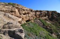
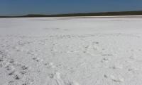
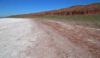
Photo tours in Mary velayat.
"The land is the mistress! And I'm your skinny offspring
And you appointed me a royal lot,
So that in the depths of your hidden ancient power
Fire, unfading with metals, was buzzing.
Do not break blood ties with me, like a mother,
Give in the furious dance of your orbit chain
And blood is a red rumble and a brain is a fat load
Fold at the foot of your splendor"
Mikhail Zenkevich. "Accomplishment". 1911.
Ecological tours in Mary velayat.
Drainless Yeroylanduz depression is located on the Gyzyldzhar plateau, in the southern part of the Tejen and Murghab interfluves on the territory of the Serkhetebad etrap in the southeastern part of the Mary velayat.
There are three salt marshes in the depression: Namakshor Zapadny, Yeroylanduz and Namakshor Vostochny. The northern part of the depression is located on the territory of the Badkhyz reserve. The border of the reserve covers the northern coasts of salt marshes: Namakshor West, Yeroylanduz and Namakshor Vostochny.
The depth of the Yeroylanduz depression created by water erosion (now they are dry) is 456 meters from the level of the northern part of the chink. The bottom of the Yeroylanduz salt flat is located at an altitude of 311.3 meters above sea level.
The bottom of the Vostochny Namakshor salt marsh is 331.7 meters above sea level. The bottom of the salt marsh Namakshor West is 462.1 meters above sea level. The eastern boundary of the Yeroylanduz basin is a group of salt marshes stretching in the meridional direction.
Salt Lake Dengligel is the most southeastern border of the depression. Further to the north lies the Shoramak salt marsh, then two unnamed salt marshes. Even further, the eastern parts of the pistachio forests located on the eastern slopes of the Ellibir ridge located on the territory of the Badkhyz reserve.
The northern border of the depression is the Badkhyz reserve and the southern slopes of the Duzenkyr ridge. From the east, the depression is bordered by the Kulan Valley and the western slopes of the Akhatkaya ridge.
In the southeast, the depression is bordered by the Benti-Disan mountains. In the south, with the northern spurs of the Sambkhe-Kyariz ridge located on the border of Turkmenistan and Afghanistan. The depression has a sublatitudinal strike, its length from southwest to northeast is 38 kilometers.
The greatest width in the central part, east of the Yeroylanduz salt marsh from north to south, is 14 kilometers. The perimeter of the Yeroylanduz depression is: perimeter 25.36 kilometers, area 12 square kilometers.
Namakshor Western depression: perimeter 58.52 kilometers, area 173.54 square kilometers. Vostochnaya Namakshor depression is: right: perimeter 63.95 kilometers, area 221.15 square kilometers. The area of the Yeroylanduz depression is 406.69 square kilometers.
Between the salt marshes Namakshor Zapadny and Yeroylanduz there is a 5.8 km long cofferdam, which stretches from the edges of the chink from north to south. Between the salt marshes Yeroylanduz and Namakshor Vostochny, there are the Ostantsovy mountains, which are located on the territory of the Badkhyz reserve.
The height of individual outliers ranges from 2 to 8 meters. The largest number of high outliers is concentrated in the northern part of the Ostantsovy mountains. The dominant height of the Ostantsovy Mountains is located in the northern part, 425.1 meters above sea level.
The cone-shaped hills of the Ostantsovy mountains in the Yeroylanduz depression represent the repaired erosion of the vents of ancient volcanoes. Some relief forms of the Yeroylanduz depression are composed of volcanic rocks, for example, a group of small hills - the Ostantsovy mountains.
Some hills are composed of basalts or tuff, hardened after eruptions, and layers of crystallized gypsum sparkle. In the eastern and northeastern part of the Yeroylanduz salt marsh, there is a relief peninsula, with its configuration reminiscent of the profile of a cat.
The peninsula is dominated by Mount Kazan with a height of 1462.2 meters above sea level. The Yeroylanduz and Namakshor Vostochny salt flats are connected by a channel that runs in the southern part of the Ostantsovy mountains.
The channel from the Vostochny Namakshor salt marsh turns into the grandiose Gyzyljar ravine with a length of 17 kilometers. The picturesque Gyzyljar ravine is connected to the Yeroylanduz depression in the northeastern part.
The depth of the ravine in the southern part reaches 356 meters from the surface of the chink, in the central part the depth of the ravine reaches 200 meters. In the northern part, in the vicinity of the Giziljar cordon, the depth of the ravine is 73 meters from the surface of the chink.
The dense silt soil of the bottom of the depression helps to collect atmospheric precipitation, and as a result of evaporation, a large layer of salt remains at the bottom. The outskirts of the basin are surrounded by a group of remnant hills.
Black volcanic rocks and rocks stand out from the white salt deposits. In addition, traces of plants that existed in these areas many thousands of years ago were found on the open andesite and basalt layers. In the Yeroylanduz basin, there are mainly desert plants, including black saxaul and areas with thickets of saltwort.
In spring the salt marshes are filled with salty water with a bottom pink from the settled Glauber's salt, in summer the water dries up and a flat salt marsh spreads here. Obviously, the Yeroyulanduz depression in the Neogene was a lagoon of a gradually drying out warm sea.
Large mollusks were found in its waters, many of their shells weighing up to two kilograms now lie in a strip indicating the line of the shallow waters of the former lagoon. Millions of years ago, many subtropical trees and shrubs grew on its shores.
Paleobotanists have found here on the slabs of sedimentary limestones remnants of extinct evergreen plants. Clear imprints of leaves, fruits and cones of laurel, cypress, cedar, pines and other subsequently extinct trees.
Geographic coordinates of Yeroylanduz depression: N35 ° 40'13.38 "E61 ° 48'25.04"
Authority:
Alexander Petrov.
Book “Nature of Turkmenistan”. Ashgabad. 2002.
Photos by
Alexander Petrov.