You are here
Depression of Zhygylgan.

Mangyshlak road trip.
“Thought is invisible nature”
Heinrich Heine.
Excursion rounds and rest on Mangyshlak.
The Zhygylgan sinkhole is located in the northeastern part of the Tyup-Karagan peninsula, washed by the waters of the Mangyshlak Bay in the Caspian Sea, south of Cape Zhygylgan in the Tupkaragan district of the Mangistau region. Zhigylgan (translated from the Kazakh language as “Fallen Land”). At the point of descent from the chink to the basin, the height above sea level is 157.8 meters, and the coastal part in the vicinity of Cape Zhigylgan is only 5.3 meters above sea level.
150 meters in height is the height difference in the dip. The length of the Zhigylgan dip from north to south from the rim of the rank and to the western tip of Cape Zhygylgan is 4 kilometers 254 meters, the largest width from west to east is 2.7 kilometers.
The circumference of the dip is almost 12 kilometers. As a result of a powerful earthquake in antiquity, a giant landslide was formed, which created a giant basin with a diameter of more than 5 kilometers on the western coast of the Caspian Sea.
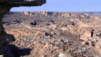
From the edge of the chink, one can observe stone chaos spreading underfoot, stone blocks of complex fantastic and regular geometric shapes, stone towers, stone cubes, castles and animal figures. If it were not for the sea approaching the Fallen Earth on one side, this place would have looked like a huge bowl filled with a pile of rocks resembling the ruins of castles, circus arenas, fortress walls of a huge ruined city, a quarry.
The endless steppe suddenly breaks off by a steep cliff that resembles the shape of a crescent moon, about 3 kilometers long. The sheer, western wall of the dip in places reaches 50 meters. At the base of this wall is unimaginable stone chaos.
Here, a massive limestone slab 30 – 35 meters thick, which forms the surface of the Tupkaragan plateau, fell into the void, turning into a heap of cracked massive blocks, walls and towers. This natural "dump" stretches for 4 km to the very shore of the sea.
Zhygylgan is a huge geological landslide that arose as a result of saturation with moisture of a clay-sand surface on which a layer of limestone rested. The origin of the tectonic dip associated with horizontal movements of the lower layers of limestone.
The contours of ancient failures are observed throughout the northern part of Tyupkaragan. This is due to the drift of the continents, in this case, movements occur from the southwest to northeast. The speed of horizontal movements increases with depth, the layers slip, leading to their rupture and the formation of karsts, where the overlying layer failed!
This was accompanied not only by geodynamics, but also by hydrodynamic processes. It is very likely that such an area of the Tyupkaragan "armor" could move as a result of a powerful earthquake. A heavy plate with its own weight squeezed out the soft litter and threw it into the sea, and itself turned into a fantastical failure.
Most likely, a landslide has occurred in historically recent times. Having destroyed the limestone shell, nature gave us a rare piece of the former earthly life. It is believed that the limestone shell of Ustyurt and Mangyshlak is formed by sedimentary rocks of marine origin.
But the split blocks revealed a whole layer of petrified silt. There is a small salt lake, the density of water in which allows you to keep the human body afloat. Somewhere in the clefts a glade hides with exceptional plants for the desert zone and semi-deserts - ferns.
Here, mountain sheep - mouflons - can still be saved from hunters. Zhygylgan was a place of natural refuge for people in antiquity. Archaeologists know in stone chaos three dilapidated fortresses of the XIV - XV centuries and the mass of cave paintings. And with all this, Zhygylgan remains a place far from known and mysterious.
They say that spirits live here.
Geographic coordinates of the Zhygylgan dip: N44 ° 36'36.49 "E50 ° 49'12.15"
Authority:
Antonina, Andrey Astafyev, the city of Aktau.
Photos by
Aleхander Petrov.


