


![]()
You are here
Desert plains of Moyunkum and Sary-Ishikotrau.

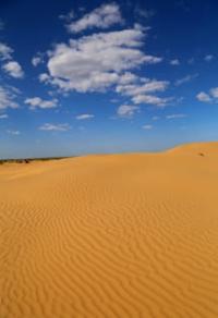
Most beautiful nature of Kazakhstan.
"Hot sun, hot sand,
Hot lips, take a sip of water
There is no trace in the hot desert,
Tell me, caravaneer, when is the water?..."
Yuri Entin.
Unique places of nature in Kazakhstan.
To north of Tien-Shan and Dzungarskiy Alatau, below foothill plains, there are large areas of sand - Muyunkum, Taikum and Sary-Ishikotrau. Moyunkums are located between Karatau and Chu-Ili mountains, in north they are limited by valley of Chu river.
The sands of Taikuma are located between the Chu-Ili mountains and the valley of the Ili river. Saryesik-Atyrau (also Sary-Ishikotrau) sandy desert is located in the south and southeast of Lake Balkhash, north of the Malaysary ridge in the Ili district of the Almaty region and in the Koksu district of the Zhetysu region.
These sandy plains are located in the northern subzone of the desert zone. The Moyunkums gradually decrease in a northwestern direction, towards the lower reaches of the Sarysu River, from 700 m. a. s. l. in the extreme southeastern part of the desert to 150 meters in the northwestern one.
Moyunkums decrease in a northerly direction, forming a series of steps. The desert is characterized by ridge-hilly, small ridge and hilly sands. Along the northern outskirts of the Moyunkums, a loamy plain adjoins the valley of the Chu River.
The surface of the plain is intersected by numerous old dry channels of the latitudinal direction.
Moyunkums are located within the Chu-Talas depression. To the north, on the southern slope of the ledge of the folded Paleozoic basement of the platform, there is the Betpak-Dala plain, composed of Tertiary rocks. Within the Moyunkums, the folded Paleozoic basement subsided even deeper.
In the northwestern part, the folded basement comes to the surface in the valley of the Chu River, and carboniferous limestones form rapids in the riverbed. The Chu-Talas basin is filled with a sequence of Cretaceous (clays, sands, sandstones) and lower Tertiary rocks overlain by Quaternary sands with interlayers of loams.
The Mounkum sands are ancient (Quaternary) alluvial and fluvioglacial deposits, blown from the surface by the wind, which created a complex of eolian landforms. The formation and accumulation of sands is associated with the glaciation of the mountains in the Quaternary.
At that time, numerous rivers flowed from the northern ranges of the Tien-Shan. They were incomparably more full-flowing than now, and flowed into the Talas and Chu rivers. The Talas River flowed into the Chu River, the Chu connected with the Sarysu River, and then, after their confluence, the Chu flowed into the Syr-Darya.
In the post-Quaternary time, this system of rivers broke up, the river network gradually acquired a modern look. The modern valley of the Chu River is well developed and has a series of terraces on its slopes. As the flow reduced and the rivers became isolated, the process of filling the Chu-Talas depression continued, and the rivers, retreating, left a number of deltas inside the valley.
The Balkhash sandy deserts - Taikum, Sary-Ishikotrau and Lyukkum - arose in the same way as the Moyunkums. All these deserts have a common history of development. The Balkhash deserts occupy a depression - the Balkhash-Alakul graben.
This depression is separated from the Chu-Talas depression by a relatively narrow bar of folded Paleozoic basement, which forms the Chu-Ili mountains. The Balkhash-Alakul graben was filled with loose alluvial and fluvioglacial deposits in the same way as the Chu-Talas depression, and at the same time.
Lake Balkhash during the period of glaciation of the Tien-Shan and Dzungarian Alatau ranges was incomparably larger and stretched to Lake Alakol inclusive. In the post-glacial period, the size of the lake was greatly reduced, since its basin in the southern part was filled with sediments, the water level dropped, and the lake broke up into parts: the currently existing lakes Balkhash, Sasyk-Kul and Alakol.
The scale of the transfer and accumulation of fluvioglacial and alluvial material is evidenced by the so-called Bakanas plain, which occupies about half of the Sary-Ishikotrau desert. It is an ancient delta of the Ili River. The huge triangle of the Bakanas Plain is composed of deltaic and lacustrine sandy-argillaceous deposits.
The whole plain is intersected fan-shaped diverging old channels of the Ili rivers - "bakanas" - up to several hundred meters wide. The modern delta of the Ili River, like other rivers - Karatala, Aksu and Lepsy - abounds in lakes and channels, large areas in the deltas are covered with thickets of marsh grassy vegetation.
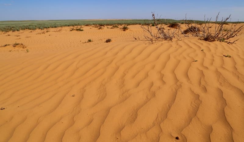
Salt marshes are widespread in the deltas, large areas are occupied by sands. The modern relief of the Balkhash sandy deserts is largely determined by the fact that they are fixed by vegetation. Moving dune sands, as in other deserts of Central Asia, are associated with human economic activity and are found in riverine strips, along roads and in places on pastures.
In the Balkhash region, large areas are occupied by sandy plains, hilly, hilly-ridge and ridge sands. From the surface, the sand layer has been blown out. The climate of the Muyunkum and Balkhash deserts is sharply continental. The average temperature in January is -10°, the minimum is 45°, in July +26°, the minimum is +45°.
Precipitation is about 150 mm per year, with the most precipitation in spring. The snow cover is very thin and unstable. During the year, northerly winds dominate.
Soils of desert plains of Muyunkum and Sary-Ishikotrau.
The soil cover is dominated by brown soils. In their structure and composition, they are close to gray soils. The humus horizon of brown soils is colored in brownish tones and is replaced by a pale-yellow carbonate horizon.
Brown soils are formed on light, fine-earth, rich in mineral salts, parent rock, which ensures their fertility.
Vegetation of desert plains of Muyunkum and Sary-Ishikotrau.
Vegetation cover is very sparse with less than 50% coverage. This favors the development of lower plants on the soil - lichens, algae and mosses. The period of summer dormancy, caused by high temperatures and dryness, is absent in these deserts, as well as in the entire northern subzone of the desert.
The most common are xerophytic shrubs, especially wormwood (Artemisia terrae albae). The deserts are characterized by a sagebrush-saxaul complex, torn by wedged takyrs. White saxaul grows on sands - ridge, hilly and ridge-hilly.
Black saxaul grows in silted depressions, a tree-like hodgepodge reaching 8 meters in height, with a thick, gnarled trunk, leafless.
In Moyunkum, thickets of white saxaul occupy the northern part, while grassy vegetation dominates in the southern part. The composition of herbaceous vegetation varies depending on the relief and soil. On the tops of ridges and mounds on the sands grows dzhusgun (CalligopitCaput Medusae), on loamy slopes - wheatgrass, or erkek (Agropyrum sibiricum), wormwood - red (Artemisia scoparia) and camphor (A. eucodes), wild rye (Secale fragile), and in depressions - mainly sandy sedge (Carex pachystylis).
Teresken (Eurotia ceratoides) and Astragalus (Astragalus brachypus) dominate in the central part of Muyunkum. Intrazonal vegetation spreads along river valleys. Tugai occupy the floodplain. Typical for them: willows (Salix gmelini, S. songorica), sucker (Elaegnus angustifolia), clematis liana (Clematis orientalis), wrapping around the trunks and branches of trees, in the second tier - shrubs: honeysuckle, barberry, tall grasses - licorice (Glycirrhiza uralensis ), bluegrass (Poa pratensis).
Behind the tugai belt there are tall-grass water meadows (the height of the herbage is 1.5 meters). On the surface of the second terrace, dry forb meadows are common - sedge, reed grass. The third terrace is outside the influence of the river, its floods and is covered with wormwood, saltwort, comb, sarsazan, etc.
Fauna of desert plains of Muyunkum and Sary-Ishikotrau.
The fauna of the Muyunkum and Balkhash deserts consists of animals typical of sandy deserts. They meet: goitered gazelle, corsac fox, wolf, many rodents: thin-toed ground squirrel, gerbils - large and midday, jerboas - terry-legged, crested-toed.
Reptiles are also numerous: scapteira lizards (netted and striped), round-headed lizards (eared, sandy), steppe boa constrictor, steppe tortoise. In the tugai live: wild boar, tiger, jackals, reed cat, hares (tolai) are numerous, pheasants are common, feeding on sea buckthorn berries and djids.
For tugai, kingfishers, sandpipers, herons (gray and white), bitterns, and cormorants are also typical.
Geographical coordinates of Moyinkum sands: N44°24'15 E69°54'26
Geographical coordinates of Saryesik-Atyrau (Sary-Ishikotrau) desert: N45°18'56 E76°21'48

Authority:
http://big-archive.ru
Photos by:
Alexander Petrov.