


![]()
You are here
Fortification of Kalmaktobe.

Adventure trip in Kazakhstan.
“We are surrounded on all sides by enemies: on the one hand, the Khasaks (i.e., Kazakhs. I. . E.), on the other, the Buruts (i.e., Kyrgyz. I. E.) everywhere large detachments are required to guard, and it's annual"
1714. Khuntaiji Tsewang-Rabdan, Report to Emperor Kazhy.
“On their borders, for all caution, they have a not-so-popular guard. There are guards at the borders from them, the Zengorians, - reports another modern source, - in Persian three hundred with the noyon of Amyz Gosyamachi, and in Chinese five hundred with two noyons, ... they change after two years."
Researcher of the Orenburg region in the middle of the XVIII century P. I. Rychkov. Oirat Border Guard.
Fortresses and fortifications in Almaty region.
Kalmaktobe fortification is located at an altitude of 567 meters above sea level, located in the northern part of the Beskol tract, 11 kilometers north of the Anyrakai tract, 26.5 kilometers southwest of the village of Kanshengel, 16.3 kilometers northeast of small village of Almaly, 41.7 to the west and slightly south of the village of Aidarly in the Zhambyl district in the west of the Almaty region.
From the fortifications of Kokkesene and Akkesene in the direction from west to east, there were more than ten Dzhungar guard posts of various sizes in carved places, of which the Kalmaktobe fortification was the closest to the Ili River valley.
It was erected by the Oirots on the southern natural boundary of the Beskol tract at the confluence of the Sary-bulak river, which flows into the plain from the northern slopes of the Anyrakai Mountains, with the dry channel of the Karakemer channel.
As you know, about 11 kilometers south of the Kalmaktobe fortification in the Anyrakaya natural landmark in 1730, the famous, historical Anyrakai battle took place between the Kazakh militia led by Khan Abulkhair and the Dzungarian army. This fortress had a square shape in plan and was oriented by the corners to the cardinal points.
The monument was first marked in the form of some nameless ruins on large-scale maps of the Yli region only in 1957, since geodetic surveys were not carried out on this territory until the middle of the last century. Under the name "Mound Kalmaktobe" it began to be fixed on the topographic maps of the Western Semirechie since 1963 after the second geodetic survey was carried out here, during which topographers managed to identify the mud ruins of the old building, according to local old-timers of the region, as the former fortification of the "Kalmaks "(Correctly Oiratov I.E) - Kalmaktobe.
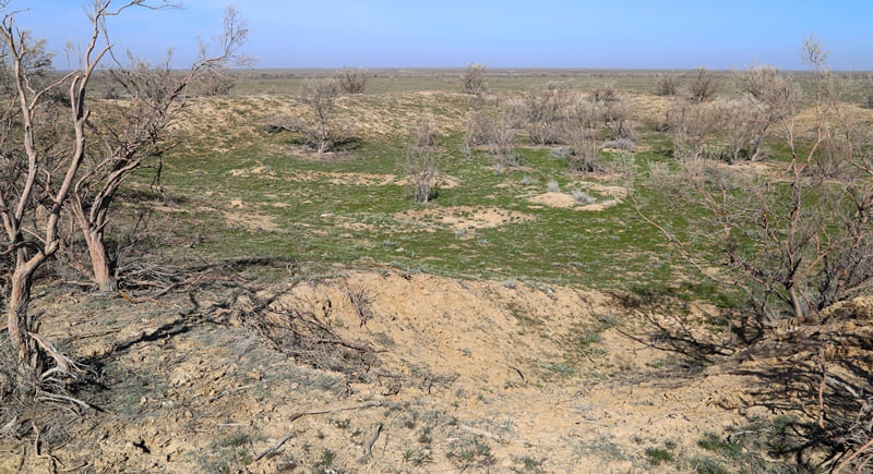
The Kalmaktobe complex occupies the left elevated bank of the Sarybulak River and includes a group (ensemble) of various structures: a fortification surrounded by a defensive wall, the remains of several other isolated buildings, irrigation facilities and water supply - kyariz, ditches and water tanks.
The fortification of Kalmaktobe is a small, 50 x 50 meters, quadrangular defensive structure (tortkul) in plan, oriented by the corners to the cardinal points. As a result of the conducted research, it was found that the relative height of the walls of the fortification from the outside is 1.5 meters; the inner surface is flat, without visible signs of building, gradually descends towards the center, the height of the walls relative to the inner surface of the tortkul is 1.8 meters.
The surface of the fortification is covered with sparse herbaceous vegetation, along the shaft and inside the structure there are thickets of saxaul. Nearby were also found two processed granite blocks of pink color with recesses on the end face, similar to the stone bases of the columns, which in 1851 the famous geographer A. Vlangapi found in the ruins of the famous lamaist temple Ablaikit (Ablai-sum, 1654 - 1671 on territory of the East Kazakhstan region in the vicinity of Ust-Kamenogorsk).
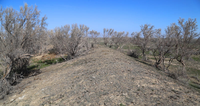
In the middle part of the southeastern wall, a gap and a lowering of the rampart are clearly visible, probably fixing the place of entry into the territory of the fortification. At the corners of the tortkul, there is a slight increase in the shaft, possibly indicating the presence of buttresses.
The reconnaissance excavations carried out on the fortification of Kalmaktobe (two pits 1.5 x 3 meters and a trench 1.5 - 6 meters) revealed the presence of a cultural layer not rich in finds and made it possible to determine the nature of the defensive structure itself: the fortress wall was made of unbaked bricks measuring 21 x 29 x 7 cm, 28 x 35 x 8 cm; the height of the preserved wall masonry is about 2 meters from the base.
During the excavations carried out at the monument (headed by A.E. Rogozhinsky), an insignificant cultural layer was revealed, which indicates the unstable nature of habitation inside the fortification: a section of the fortress wall was explored and lifting material was collected, including two large-caliber lead rifle bullets.
On the surface of the southeastern wall of the Kalmaktobe fortification, on the outer side of the rampart, flakes and knife-like blades were collected. Taking into account the conditions of finding stone artifacts, it should be assumed that they were redeposited during the construction of the late fortification, together with clay used to make bricks and a binder mortar.
Geographical coordinates of Kalmaktobe fortification: N44°09'32 E75°18'32

Authority and photos
"Anyrakay Triangle Historical-Geographical Area and Chronicle of the Great Battle". I.V. Erofeeva, B.Zh. Aubekerov, A.E. Rogozhinsky, B.N. Kaldybekov, B.T. Zhanaev, L.L. Kuznetsova, R.D. Sala, S.A. Nigmatova, J.M.P. Deom. Almaty, 2008. "Dyke Press".
Photos by:
Alexander Petrov.