


![]()
You are here
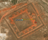
Fortification of Kyzylkorgan.
Archaeological monuments in Kazakhstan.
“Thousands of selected camels went with him,
And there were no loads of rich numbers.
One hundred red camels with dirhams walked,
And dinars carried forty camels...
With packs, where musk and the best scarlet,
With silks that dazzle the eyes with beauty,
Their Chin supplies both Mysr and Iran -
here was another caravan in thirty camels.”
Poet of the medieval East Firdousi.
Monuments in valley of Talas River in Kazakhstan.
Kyzylkorgan (kaz. Kyzylkorgan) - II - a medieval fortification, located at an altitude of 376 meters above sea level, located 2.3 kilometers from the western edge of the Moyuynkum desert, 4.3 kilometers northeast of the small village of Turymkul (Bestam), 8 kilometers from the right bank of the Talas River, 17.9 kilometers southeast of the village of Boltirik sheshen, 19.1 kilometers northwest of the village of Tamabek (Amangeldy), in the Oyik rural district in the Talas district of the Zhambyl region.
In 1948, it was explored by the South Kazakhstan archaeological expedition led by A.N. Bernshtam. According to Bernshtam, in the 19th century it was used as a caravanserai. In 1980, it was explored by the Zhambyl Regional Museum of History and Local Lore under the leadership of K. Baibosynov, in 1983 by the archaeological team of KazGU under the leadership of M. Eleuov, in 2000 by the South Kazakhstan complex archaeological expedition led by Karl Baipakov.
There are two fortifications on the territory of the Tallas region - Kyzylkorgan-I and Kyzylkorgan-II. Kyzylkorgan-II is rectangular, area 165 × 170 meters. Surrounded by a duval 20 meters wide, 2 meters high. The sites of 15 watchtowers have been preserved.
Outer gate on the northeastern outskirts. The settlement is surrounded by a moat 2 meters wide and 2 - 2.5 meters deep. The found objects show that in the X-XII centuries the ancient settlement was a settlement.
The Kyzylkorgan-I fortification is a medieval fortification, located at an altitude of 369 meters above sea level, located 10.3 kilometers from the western edge of the Moyuynkum desert, 4.2 kilometers southwest of the small village of Turymkul (Bestam), 120 meters from left bank of the Talas River, 17.4 kilometers southeast of the village of Boltirik sheshen, 3.1 kilometers north and slightly east of the village of Oyik, in the Oyyk rural district in the Talas district of the Zhambyl region.
The fortification of Kyzylkorgan-I is a quadrangular hill, area 32 × 32 meters, height 2 meters. Around it is a moat 4 meters wide and 0.5 meters deep. Surrounded by a duval 8-10 meters wide. The remains of 8 watchtowers have been preserved on the duval.
The outer gate of the fortress on the northwestern outskirts. From an exploration pit with an area of 1 × 1.5 m duval, a cultural fortification layer of 2 meters was determined.
Geographic coordinates of Kyzylkorgan-II fortification: N43°52'18.78" E71°00'59.03"
Geographic coordinates of Kyzylkorgan-I fortification: N43°48'58.47" E70°56'43.60"
Authority:
https://ru.wikipedia.org/wiki
Photos by
Alexander Petrov.