


![]()
You are here
Geological sections of Aktobe region.

Tours in the cities of Kazakhstan.
“The land is mistress! And I'm your skinny son
And you appointed me a royal inheritance
So deep in your hidden ancient power
The fire that did not fade with metals hummed.
Do not break with me like a mother, bloody bonds,
Give in the frantic dance of your orbit chain
And blood red buzz and brain fat load
Add to the foot of your magnificence"
Mikhail Zenkevich. "Accomplishment". 1911.
Sightseeing tours in Kazakhstan.
Aktobe region, located at the junction of three large geological structures - The Russian platform, the Ural fold system and the Turan plate are rich unique geological sections.
Geological sections are the main documents of past geological epochs depicting the conditions and processes of a long the development of the earth's crust on the fossilized remains of the organic world. In the area there are unique natural geological sections with well-preserved remains flora and fauna that are important for studying the stages of formation region and the wealth of its bowels.
According to the Decree of the Government of the Republic of Kazakhstan “On approval of the list of objects of the state nature reserve fund” No. 932 of September 28, 2006, in the Aktobe region to the state nature reserve fund republican significance included unique natural water bodies, geological and geomorphological objects - subsoil areas representing a special ecological scientific, historical, cultural and recreational value.
Geological objects of the state nature reserve fund of republican and international significance are represented by subsoil plots in the Aktobe region:
Auliinsky massif.
The Auliinsky massif is an outcrop of Upper Devonian sediments in the valley of the Auliya stream, located 20-30 km east of the city of Emba. Reef building. The object is of interest for geological research and scientific excursions.
Paleogene and Late Cretaceous Tykbutak deposit.
The rich location of the remains of plants and animals of the Paleogene and Late Cretaceous at the Tykbutak stream is located on the right bank of the Tykbutak stream, 3 and 8.5 km from its mouth. In addition to the imprints of the leaves of ancient plants, numerous teeth of fossil sharks (mudflows) are found.
The object is of interest to professional geological and paleontological research.
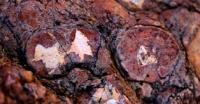
Cephalopod of the Lower Permian Aktasty deposit.
The rich location of the Lower Permian cephalopod remains on the Aktasty River - the rich location of the Lower Permian cephalopod residues of Assel, Sakmara and Artinsky tiers of the Lower Permian is located on the right bank of the Zhaman-Kargaly River, 2 km east of the Aktasty River.
The length is about 2 kilometers. The section is characterized by interbedded sandstones with siltstones and mudstones. In the section, dolomitic limestones, rich in numerous ammonites, direct nautiloids, and bactritoids, among which brachiopods and a few fusulinids are present, acquire significant importance.
The most important, from a biostratigraphic point of view, are cephalopods, especially ammonites, which are typical exclusively for the Artinian layer of Lower Perm. The complexes of ammonites and fusulinids allow us to compare the section of the tier to the horizons inclusive of the Aktobe Ural region with a unified regional stratigraphic diagram of the entire Urals and with a single stratigraphic scale.
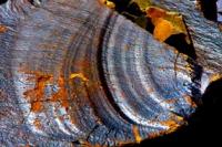
Aktastinsky reef.
Algal reef limestones of the Lower Permian age of the Aktastinsky reef, located on the western wing of the Belogorsk anticline, 20 km east of Aktobe. The body of reef limestones is located on the site of changing the sublatitudinal direction of the Aktasty River to the meridional one, where the river divides the reef body into two parts - northern and southern.
Reef limestones occur on the horizon of algal undulating-layered limestones of the Artinskian stage. The reef body in the erosion section has the shape of an irregular lens-visible-branched body elongated in the meridional direction by 2.5 km with a width of up to 1 km in its central part.
At present, the northern, eastern, and western parts of the reef body have been preserved, while the southern has been mined by a quarry for building materials. Limestones are strongly karst, often contain bodies of marble onyx of significant fracturing.
Onyx, obviously, was fixed in karst cavities made of clay-brown-iron-clay-clay material, sometimes forming stalactites and stalagmites. The exposed walls of the quarry allow for a qualitative study of the internal structure of the reef body.
Limestone-terrigenous stratum Burtebai.
The limestone-terrigenous sequence at the Burtebay stream is one of the most complete sections of the boundary layers between the Devonian and Carboniferous. The limestone-terrigenous sequence containing astrocodes, foraminifera, conodonts is located in the valley of the Burtebay stream, the right tributary of the Shuyldak river, 12 km northeast of the station Berchogur of the Shalkar district. The object is of interest for professional geological and paleontological research.
Kyzyltobe oligocene deposit.
Imprints of plants of Oligocene age on the Kyzyltobe Upland - a rich location of prints of plants of Oligocene age in ferruginous sandstones and siltstones on the left bank of the Kundizdy River in western Primugalzharya.
Paleovolcano Zhalgiztau.
The Paleovolkan Zhalgyztau is a large, well-preserved extrusive andesitodacite structure with remains of an island-type volcanism slag cone located in the upper reaches of the Milyasha River in the south of Mugalzharv, Shalkar district.
Sands of Kokzhide.
Sands of Kokzhide - a unique reservoir of fresh water, located in the Temir district, on the right bank of the Zhem river south of the latitudinal flow of the Temir river. Cretaceous are involved in the geological structure of the Kokzhide fresh underground water deposit.
Quaternary and modern sediments. Water-bearing sediments represented well-permeable different-grained sands up to 10 - 12 m thick. Mineralization groundwater 0.14 - 0.48 g / l. Water supply mainly due to atmospheric infiltration precipitation, meltwater during floods and groundwater inflow from Cretaceous deposits.
Ore occurrence South Zhamantau.
Ore occurrence South Zhamantau is a deposit of copper-magnetite ores with unique copper quarries in the South Zhamantau mountains of the Shalkar district that exposes on the surface and composes the top of the South Zhamantau mountain.
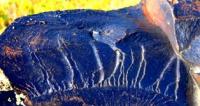
Serpentinite melange Alimbet.
Serpentinite melange (Devonian-Carboniferous) on the Alimbet River - the exposure of rocks of the Ordovician-Silurian age in geomorphological terms is exposed on the southern slopes of the sub-latitudinal ridge located along the right bank of the Alimbet River.
It frames one of the tectonic scales from the south in the western part of the Sakmara structural and formation zone and separates the terrigenous complexes of the Lower Ordovician and the volcanic-sedimentary formations of the Lower-Middle Ordovician and Silurian.
Serpentinites are intensively flared, brecciated. Contain numerous clips, blocks, blocks of rocks of various composition. The high steep banks with greenish-blue outcrops create a colorful picture and can be shown to tourists.
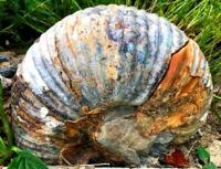
Ammoids in the Dombar hills.
The accumulation of early carbonic ammonoids in the Dombar hills is unique and the richest locations of ammonoids in limestones of the Lower Carboniferous on average the Dombar River, between the rivers Dombar and Alabaital, 55 km northeast of Aktobe Cephalopod facies of clusters are typical for the genes of the upper vise and Serpukhov tier.
They were first studied by Ruzhentsev and Theological (1971). By them the ammonoids of these richest locations were restored the course of evolutionary development of this group, which served as the basis for stratigraphic division carbon fiber.
Comprehensive study and collection of fauna of conodonts, foraminifera and other minerals is of great importance for clarifying the nature of boundaries and lithological and sedimentological analysis of rocks of the border interval.
Salt dome of Boktygaryn.
Lower-Upper Maastricht Border – Data not found.
Shuyldaksky paleovolcano.
Shuyldaksky paleovolcanic region - fragments of paleovolcanic buildings in the southeastern part of Mugalzhar, in the Shuyldak river valley (over 20 km) in the wintering areas of Arstanbai, Donglelek, Aktogay, Iskhak letnik of the Shalkar district. Lavas of various morphology - cushion, tube-shaped, stratum.
Parallel dikes, extrusive lava and geyser structures.
Authority:
Natural resources of Aktobe region. Ecoproject LLP. 216 p.
Photos by:
Alexander Petrov.