


![]()
You are here
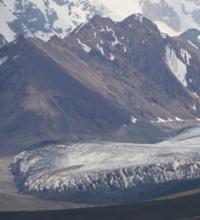
Glacier Chuloktor Eastern.
Tours and travels in mountains of Kyrgyzstan.
“The virtue of the sages resembles a journey to a distant land and an ascent to the top: those going to a distant land begin their journey with the first step; Those who ascend to the top begin at the foot of the mountain."
Confucius.
Sights in mountains of Kyrgyzstan.
Chuloktor East glacier is located between Chuloktor West glacier in west and Kichik Sauktor glacier in east, located on northwestern slope of Kokshaal-Too ridge in Jety-Oguz region, in south of Issyk-Kul region.
One of the westernmost tributaries flows from the Chuloktor East glacier, which forms the Sauktor River.
The Sauktor River is a right tributary of the Dzhangart River. The area of the glacier is 5.58 square kilometers, the perimeter of the glacier is 15.84 kilometers. The length of the glacier is 4.9 kilometers. The glacier is located on the northwestern slope of the Kokshaal-Too ridge; its sources are located in the main ridge at an altitude of 5025 meters above sea level.
The glacier tongue is located at an altitude of 3578 meters above sea level. The Chuloktor Eastern glacier is separated from the Kichik Sauktor glacier by a ridge stretching from southeast to northwest with a length of 8.6 kilometers.
The Chuloktor Western glacier is separated from the Chuloktor Eastern glacier by a submeridional ridge 13.3 kilometers long, which ends at an altitude of 2824 meters above sea level at the confluence of the Dzhangart and Sauktor rivers.
Geographic coordinates of Chuloktor Eastern glacier: N41°42'30 E79°01'09
Authority and photos by:
Alexander Petrov.