


![]()
You are here
Glacier of Semeonov.
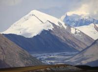
Glaciers of Kyrgyzstan.
“Using long poles with sharp ends, we gradually climbed to the top of the hill, where we had to rest, as we were overcome by severe shortness of breath from the thin air. Having rested, we had to descend a steep ice slope, which presented new difficulties: on a steep slope, up to 30 degrees, it was very difficult to hold on with poles, the iron ends of which slid on the hard ice, just like the spiked horseshoes on our boots; steps had to be cut down. We moved forward, in general, safely, although we did not do without falling and sliding down steep slopes.”
Ivan Vasilievich Ignatiev. "Study of the upper reaches of Saryjaz." 80s. XIX century.
Combined tours and routes in mountains of Kyrgyzstan.
Semenov dendritic glacier is located at an altitude: end of glacier is 3482 meters above sea level, upper limit of glacier is 5816 meters above sea level - Semenov Peak and 5488 meters above sea level - Ignatiev Peak, located in upper reaches of Saryjaz valley, in northeastern part of Central Tien Mountains -Shane, in Ak-Suu district in southeast of Issyk-Kul region.
The glacier is located on the northern slopes of the Saryjaz ridge, on the western slopes of the Katta-Ashutor ridge and on the southern slopes of the eastern part of the Terskey Ala-Too ridge. 5 large glaciers flow down from the northern slopes of the Adyrtor ridge and are the left channels of the Semenov glacier.
Their tongues on the surface of the main trunk are bordered by moraine ridges. There are only 2 right, small tributaries of the glacier, one of which is Ashutor Northern, flowing from the southern slopes of the eastern part of the Saryjaz ridge. The tongue of the Semenov glacier is flat, its surface is covered with sinkholes resembling karst ones, with a diameter of up to 30 - 50 meters.
In some, meltwater accumulates, forming lakes. Melting on the tongue of the glacier at an altitude of 3700 meters above sea level averages 2.5 centimeters per day during the ablation period, the maximum is up to 8 - 10 centimeters per day. The Semenov Glacier has retreated almost 3 kilometers since 1885.
The rate of linear contraction of most large glaciers is 2 - 10 meters per year. Small glaciers have hardly changed their outlines and for the most part are stationary or close to its position (Bakov. 1983; Dikikh. 1976; Zabirov. 1958, 1962) (Dolgushin, Osipova, Rototaeva. 1972; Vinogradov, Konovalova, Psareva 1980; Catalog of glaciers. 1967 - 1979).
The length of the Semenov glacier, the sources of which begin from the southwestern slope of the Katta-Ashutor ridge, from the northwestern slope of the peak 5437 meters above sea level and from the northwestern slopes of Semenov peak 5816 meters above sea level, is 19.2 kilometers (11.2021).
The area of the glacier is 44.48 square kilometers, the perimeter of the glacier reaches 53.25 kilometers. The end of the Semenov glacier is located at an altitude of 3482 meters above sea level. The greatest width of the glacier in its upper part is up to 1.5 kilometers (11.2021).
The Saryjaz River originates from the Semenov dendritic glacier, which originates on on the slopes of Semenov Peak at an altitude of 5816 meters above sea level at the junction of the Saryjaz and Katta-Ashutor ridges.
History of discovery and research of Semenov glacier in mountains of Central Tien-Shan.
The glacier was discovered in 1857 by Russian explorer Pyotr Petrovich Semyonov (later Semyonov-Tyan-Shansky) and received the name “Ice Sea”. In the 80s of the 19th century, the traveler Ivan Vasilyevich Ignatiev proposed renaming it the Semenov Glacier, and the glacier at the head of the Adyr-Tor River gave the name to the geologist I. Mushketov, a famous explorer of Turkestan.
Geographic coordinates of Semenov Glacier: N42°20'12 E80°01'08
Authority and photos by
Alexander Petrov.