


![]()
You are here
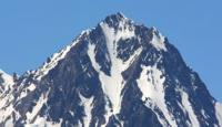
Glacier Uchitel in Kyrgyz Ala-Too ridge.
Ecological tours in Kyrgyz Ala-Too mountains.
“Neither the ice of March, nor the eternal heat,
No obelisks under the tin star
Will not cut off the tracks to the blazing fires,
To unclimbed nameless peaks."
Yuri Vizbor. "Footprints". 1962.
Glacier in Aksai gorge in Kyrgyz Ala-Too.
Uchitel glacier is located on northern slope of Kyrgyz ridge, in lateral (eastern) Aksai gorge, 41 kilometers south of city of Bishkek in Alamudun district of Chui region.
The Uchitel glacier has two branches: North, (right) with an open part of 6 kilometers and South (left) with an open part of 2.7 kilometers. The length of the closed, moraine part of the glacier is 2 kilometers. At an altitude of 3430 m. a. s. l., the moraine part of the Uchitel glacier comes into contact with the eastern edge of the Aksai glacier.
430 meters below the open part of the glacier, there is a moraine lake at an altitude of 3636 m. a. s. l. The main sources of the Northern Glacier Uchitel are located slightly east of the massif of the Semyonov-Tyan-Shansky peak, 4895.4 m. a. s. l., located in the main ridge of the Kyrgyz ridge.
Crown of peak. The sources of the Southern Uchitel glacier are located to the east of the Korona Peak massif at a height of 4860 m. a. s. l. located in the main ridge of the Kyrgyz ridge. In the upper reaches of the Yuzhny Uchitel glacier, behind the ridge in the west, there is the Korona glacier belonging to the Aksai glacier basin.
In the north, behind a sublatitudinal ridge, 1.7 kilometers long, there is the left branch of the Western Baichechekei glacier, 3.2 kilometers long, belonging to the Alamedin River basin.
Geographic coordinates of left branch of Uchitel South glacier: N42°30'50 E74°33'13
Geographic coordinates of right branch of Uchitel North glacier: N42°31'28 E74°33'37
Authority and photos by:
Alexander Petrov.