


![]()
You are here
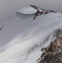
Glacier Zartoshkol (Muzkol).
Travels on glaciers in Tajikistan.
“Do not reveal old truths: everyone knows that the sun sets in the west”
Trips around Sughd region.
Zartoshkol (Muzkol) glacier is located at junction of Akbaital and Muzkol ridges, on territory of Tajik National Park, in Murghab district, Gorno-Badakhshan Autonomous Region. The glacier belongs to the Bartang River basin. The Zartoshkol (Muzkol) river, 46.5 kilometers long, is a left tributary of the Kokuybel River.
The sources of the river are located at an altitude of 4697 meters above sea level from three branches of the Zartoshkol (Muzkol) glacier. The mouth of the river is located at an altitude of 3673 meters above sea level. The Zartoshkol (Muzkol) glacier consists of three branches: Central, Western and Eastern.
Glacier Zartoshkol (Muzkol) Central.
The upper boundary of the glacier is located at an altitude of 5727 meters above sea level, the end of the glacier is at an altitude of 4551 meters above sea level. The length of the glacier is 7.43 kilometers, the area of the glacier reaches square kilometers, the perimeter of the glacier is 24.78 kilometers, and the average width is 1.68 kilometers.
Geographic coordinates of Zartoshkol (Muzkol) Central glacier: N38°26'15 E73°28'00
Glacier Zartoshkol (Muzkol) Western.
The upper boundary of the glacier is located at an altitude of 6148 meters above sea level (Dvuglavy peak), the end of the glacier is located at an altitude of 4483 meters above sea level. The length of the glacier is 8.4 kilometers, the area of the glacier reaches 9.03 square kilometers, the perimeter of the glacier is 20.13 kilometers, the average width of the glacier reaches 1 kilometer.
Geographic coordinates of Zartoshkol (Muzkol) Western glacier: N38°26'20 E73°25'42
Glacier Zartoshkol (Muzkol) Eastern.
The upper boundary of the glacier is located at an altitude of 45,424 meters above sea level, the end of the glacier is located at an altitude of 4,693 meters above sea level. The length of the glacier is 5.56 meters, the area of the glacier reaches 6.69 square kilometers, the perimeter of the glacier is 16.28 kilometers, the average width of the glacier reaches 1.6 kilometers.
Geographic coordinates of Zartoshkol (Muzkol) Vostochny glacier: N38°26'10 E73°30'06
Authority:
"Glaciers of Tajikistan". Ministry of Nature Protection of the Republic of Tajikistan. Main Directorate for Hydrometeorology and Natural Environment Observations. Dushanbe. 2003.
Photos by:
Alexander Petrov.