


![]()
You are here
Glaciers in Ala-Archa park.
Excursions in Ala-Archa park.
“The snow is hiding and waiting. Waiting for our oversight. One has only to cut the layer, maybe even shout loudly, and the slope will go away from under your feet. We know how it happens: first a soft crack, then a rustling, and then a crash. Just a second. Before you have time to look back, you will be buried under a multi-meter thickness of cold and heavy, like cast iron, snow."
A. Kuznetsov.
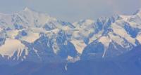
Natural sights in Ala-Archa park.
The position of the snow line in the Ala-Archi area depends on the exposure of the slopes. In the Ala-Archa gorge, the snow line is relatively low. In the Ala-Archa river basin, the snow line on the northern slopes drops to an altitude of 3500 meters above sea level, and on the southern slopes rises to 4500 meters above sea level.
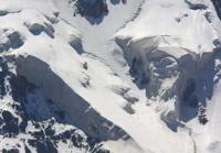
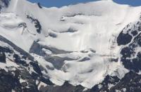
Most, large glaciers are of the valley type. Valley glaciers have extensive circuses with large firn basins that provide them with food. The longitudinal profile of valley glaciers at the transition from the firn basin usually has a steep bend.
The glacier bed is not always leveled, sometimes on their surface you can find radial cracks and icefalls (Big Icefall on the Aksai glacier). The tongues of valley glaciers descend to an altitude of 3000 meters above sea level and below, that is, significantly below the snow line.
The largest glaciers in the region are Aksai, Topkaragai, Tuyuk, and Golubika. Their speed of movement is different and insignificant. On average, it is about 30 meters per year. At present, the glaciers of the Ala-Archa basin, like all glaciers of the Kyrgyz Ala-Too, are intensively retreating.
So the Golubin glacier, for example, from 1937 to 1948 retreated by 1 kilometer, exposing a narrow deep canyon.
Ak-Sai glacier, with a length of 6.4 kilometers, an area of 4.4 square kilometers, is located at an altitude of 3220 to 4840 meters above sea level, belongs to the Ala-Archa river basin.
Glacier No. 279, with a length of 6.2 kilometers, an area of 4.1 square kilometers, is located at an altitude of 3220 to 4870 meters above sea level, belongs to the Ala-Archa river basin.
Tuyuk glacier, with a length of 6.1 kilometers, an area of 8.5 square kilometers, is located at an altitude of 3400 to 4500 meters above sea level, belongs to the Ala-Archa river basin.
Golubin Glacier, with a length of 5.6 kilometers, an area of 9.4 square kilometers, is located at an altitude of 3400 to 4420 meters above sea level, belongs to the Ala-Archa river basin.
Top-Karagai glacier, 7.7 kilometers long, with an area of 6.4 square kilometers, is located at an altitude of 3400 to 4460 meters above sea level, belongs to the Ala-Archa river basin.
Shopokov Glacier, 7.0 kilometers long, with an area of 8.8 square kilometers, is located at an altitude of 3230 to 4875 meters above sea level, belongs to the Ala-Archa river basin
Kurgaktor glacier, 6.8 kilometers long, with an area of 3.2 square kilometers, is located at an altitude of 3600 to 4520 meters above sea level, belongs to the Ala-Archa river basin.
Authority:
Kuznetsov "Alaarcha". “Defeated peaks. 1973 - 1974 ". “Mysl”. Publishing House, 1976.
Photos by
Alexander Petrov.