


![]()
You are here
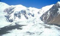
Glaciers of Vakhan Range.
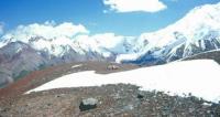
Traveling to mountains of Vakhan ridge.
“Traveling means living”
Nature of Wakhan Range.
Wakhan Range is a mountain range in the southeast of the Pamirs, on the territory of the Shugnan, Roshtkala, Ishkashim and Murgab regions in southern Tajikistan. Vakhan ridge is located in the southeast of the Pamirs in Tajikistan and Afghanistan.
Tajikistan includes the lower eastern part of the ridge from Lake Zorkul to the valley of the Oksu River. The maximum height of the ridge ridge in this section is 5790 meters above sea level, the average - 5390 meters above sea level.
The ridge rises above the vast flat valleys of the Eastern Pamirs, located at altitudes of more than 4125 meters above sea level (the edge of Lake Zorkul), therefore, despite the large absolute heights, it seems to be a mid-mountain massif with wide valleys and gentle slopes.
Only the axial part of the watershed acquires alpine features of the relief with snowy peaks and caravans. The height of the firn line is 5050 meters above sea level, lower than that located to the north ridges, which is associated with the penetration into the area through the Hindu Kush passes of the Indian monsoon.
Due to the northern orientation and the strong dissection of the ridge zone, the glaciation of the Tajik part of the Vakhan ridge is quite significant. There are 137 glaciers with a total area of 97.4 square kilometers. Of these, 59 glaciers with an area of 67.9 square kilometers belong to the basin of Lake Zorkul (Pamir River), the rest to the basin of the Istyk River (Oksu River, Murghab River).
Hanging and caravan glaciers prevail in number (55%), but in area (40%) they are inferior to valley glaciers. Valley glaciers occupy the highest mountain zone. In their nutrition plays a large role in the transfer of snow by the wind.
The surface of the glaciers is clean, glaciers with sharp edges are widespread. Glaciers of the eastern part of the Cretaceous ridge here, there is not a single glacier more than 3 square kilometers, and 76% of all glaciers are less 0.5 square kilometers.
To the west, in the basin of Lake Zorkul, the glaciers are larger. There are several complex valley glaciers, 4 glaciers more than 3 square kilometers. The largest glacier - Kara-Dzhilga (length 6.2 kilometers, an area of 10.2 kilometers square) - is located in the upper reaches of the Karadzhilgasay river (Zabirov. 1955; Forester et al. 1962; Dolgushin et al. 1972; Dolgushin, Osipova. 1982; Rototaeva. 1976, 1979, 1983; Glacier catalog. 1968, 1971 - 1980).
Geographic coordinates of Wakhan Range: N37°09'07.20" E71°40'10.48"
Authority:
"Glaciers." L.D. Dolgushin, G.B. Osipova. Series "Nature of the world." Moscow, the publishing house "Thought". 1989.
Photos by
Alexander Petrov.