


![]()
You are here
Khaivan kala (Kerder) settlements.
Sacred tour of Karakalpakstan.
"From the main city (Kyat. - V. Ya.) To Darzhash 2 days' journey, from Darzhash to Kurdar a day journey, from Kurdar to the village of Barategin 2 days."
Road workers in Khorezm al-Istakhri and al-Maqdisi.
Religious tours to Karakalpakstan.
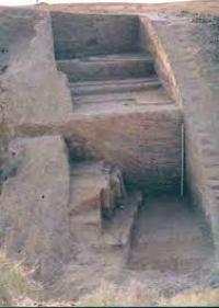
The Khaivan kala settlement is located 7.1 kilometers from the right (eastern) bank of the Amu Darya River, 8.7 kilometers to the south and a little west of the Yerkindarya village, 17.3 kilometers to the west from the Kegeili village, 15.1 kilometers to the north and a little west of the village of Krantau in the Kegeli region of the Republic of Karakalpakstan.
The Khaivan Kala settlement, one of the most significant monuments of the early medieval specific possession of Kerder, representing a late stage in the development of its material culture. The first mentions of Khaivan kala appear in literature as far back as the last century.
The scientific survey of the monument was first carried out by the Karakalpak ethnographic detachment of the Khorezm archaeological and ethnographic expedition of the USSR Academy of Sciences in 1947. The collected materials allowed S.P. Tolstov to tentatively date the settlement to the VIIth - Xth centuries and make an assumption about the possibility of identifying it with the city of Kerder, known from medieval Arab-speaking historical and geographical literature.
The collection of lifting material, carried out during the survey of the site in 1947, allowed N.N. Vakturskaya and E.E. Nerazik to characterize the ceramic complex of this site for the first time. Especially noteworthy is the work of E.E. Nerazik.
She was able to use very scarce lifting material to reveal a significant difference between the Khaivan Kala ceramics and those previously known at the synchronous sites of the Khorezm oasis and the proximity of the Khaivan Kala ceramics to the ceramics of the steppe tribes - northern neighbors of Khorezm.
In 1958, the monument was examined by the Right-Bank Archaeological Expeditionary Group of the Institute of History, Language and Literature of the Karakalpak branch of the Academy of Sciences of the Uzbek SSR (IYAL KK FAN UzSSR).
The collected data made it possible to confirm the preliminary dating of Khaivan Kala, proposed by S.P. Tolstov. In 1961, the expeditionary detachment of the IIYAL KK FAN of the Uzbek SSR for the first time excavated Khaivan Kala.
Two excavations were laid. As a result of the excavations, a powerful cultural layer was revealed, divided into several building horizons. Remains of an unfortified settlement were found around Khaivan Kala. In 1967, a special aerial photography of the monument was carried out by the Institute for Nuclear Research of the FAN of the Uzbek SSR, which provided the researchers with excellent material for studying its topography.
This settlement is located on the left side of the episodically functioning channel of the Amu Darya, Shortanbay, in the Kegeilinsky region of the Karakalpak Autonomous Soviet Socialist Republic. The area where the monument is located is low-lying, flooded during the floods of the Amu Darya.
The site was also flooded several times. Local residents talk about big floods. The flooding in the last century, both of the surroundings and of the Khaivan Kala itself, is also mentioned in the literature. For this reason, as well as because of the proximity of subsoil waters, the ground at the site is wet and saline.
The monument is densely overgrown with a comb and surrounded by riparian thickets. In plan, Hivan kala is a rectangle with sides of 400 and 500 meters, stretching almost exactly from north to south. The swollen shafts of the outer walls can be traced along the entire perimeter.
On the north-south line, it is bisected by a central depression. Nine shafts are symmetrically located on the sides perpendicular to it. They are also separated from each other and from the outer shafts by depressions, rising above their level by 1.5 - 2 meters.
The width of the shafts reaches 36 - 40 meters. The eastern wall between the fourth and fifth ramparts, counting from the south, is cut by a sharp decline, as is the southern wall along the line of the central depression.
Perhaps there was a gate to the settlement here. 0.5 kilometers to the north of it there is a conical hill of artificial origin, which rises 3.6 meters above the surrounding area. The diameter of its base is 17 meters. No ceramics, no traces of buildings between the settlement and the hill were found. At the top is a layer of wet, highly saline loam.
There is very little climbing material on Khaivan Kala. The abundance of moisture and salts contributed to the complete destruction of ceramics on the surface. Burnt bricks, which are often found on the site, are also poorly preserved.
Glass fragments occupy an essential place in the lifting material. Outside the fort on the southern side of it, as noted above, there is a huge, apparently unfortified settlement, many times larger than it in area. Flat mounds of heavily swollen buildings are located in dense riparian thickets, so it is difficult to determine the total area of the settlement.
The first data on the Khaivan kala stratigraphy and the nature of the structures that have come down to us in the form of long "ramparts" were obtained during excavations in 1961 in excavation 1, laid in the western half on the second rampart from the south.
It was found that the thickness of cultural deposits here is about 3.5 meters, and this entire sequence is divided into four building horizons, each of which is characterized by partial or complete restructuring in relation to the other.
It was also established that the "shaft" is the remains of a huge house-massif. The general nature of its layout remained unclear due to the limited area of the excavation site. Topographically, Khaivan Kala is extremely close to the settlement of Kurgancha, a monument of the early Kerder culture.
The distinguished most ancient part of Kurgancha - "regular layout" - is similar in topographic terms to Khaivan Kale. At both sites around the main core, which is more complex at Kurganch and which, judging by the regularity of the planning, arose at the same time, there is a huge unfortified settlement with unstable and elusive borders, which, apparently, took a long and spontaneous formation.
A similar situation, clearly traced in the early Kerder settlement of Kurganch, reflects the processes of the formation of an early medieval city on the semi-nomadic periphery of Khorezm.
During excavations on the Khaivan kala in 1961, a significant collection of ceramics was collected, which, according to technological characteristics, can be divided into three groups:
- easel non-irrigation,
- easel irrigation,
- molded utensils made without the use of a potter's wheel.
Pottery of the first group predominates quantitatively, the vessels of the third group are somewhat smaller, and the second group is very few in number. On Hivan Kale, we localize the ancient city of Kerder. According to V.V.Bartold, the first mention of it as a city is contained in at-Tabarn's message about the anti-Arab uprising of its inhabitants in 728.
Al-Istakhri and al-Maqdisi also call Kerder a city. The last mention of Kerdera as a city is found in the Persian-language anonym "Khudud Alalam", compiled in 902 - 903. Consequently, Kerder appears in the sources as a city for about three hundred years, from the 8th century to the Xth century.
For the first time S. P. Tolstov tried to localize the town of Kerder. He suggested that "Kerder (Kurder) is, apparently, in the area of the present Chimbay, on the right bank of the delta." However, new archaeological materials soon allowed him to clarify this localization and identify the Khaivan Kala settlement with the town of Kerder.
Subsequently, Ya. G. Gulyamov, in his monograph “The history of irrigation in Khorezm,” without refuting the point of view of SP Tolstov, localized Kerder on the site of the modern city of Chimbay. O. G. Bolshakov, referring to the absence of "a complete picture of the location of the fortified settlements and their sizes," expressed doubt about the correctness of the opinions of SP Tolstov and Ya. G. Gulyamov.
It is unlikely, however, that this link is valid in relation to North Khorezm, where, as a result of many years of archaeological and topographic surveys carried out by the Karakalpak branch of the Academy of Sciences of the Uzbek SSR, all the remains, preserved on the ground, have been taken into account, described, mapped, subjected to topographic surveys and exploratory excavations. large medieval cities and small settlements.
We had to speak out in the press about the localization of the property, the canal and the town of Kerder. However, in connection with the publication of materials from the excavations of Khaivan Kala, it seems necessary to return to this issue again.
Information about the location of the city of Kerder is available in the road books on Khorezm al-Istakhri and al-Maqdisi. In the first, the location of Kerdera is described as follows: "From the main city (Kyat. - V. Ya.) To Darzhash 2 days travel, from Darzhash to Kurdar a day travel, from Kurdar to the village of Barategin 2 days".
Al-Maqdisi describes a route where many more points are called: "from Mazdahkan to Darsan 2 post stations, then to Kardar a day's journey, then to Juvikan 2 post stations, then to the village of Barategin a day's journey, then to the lake a day's journey."
According to another route of al-Maqdisi "... from Mazdahkan to Vardarag a day's journey, then to Kardar a day's journey." It can be seen from the texts that Darzhash and Darsan are variants of the same name. Consider al-Maqdisi's road book, which contains more detailed information than the al- Istakhri.
A reliable starting point for this analysis will be the modern settlement of Gyaur Kala, where the ancient city of Mizdahkan is undoubtedly located. According to the al-Maqdisi route, there are 2 post stations from Mizdahkan to Darsan and a day's journey from Darsan to Kerder.
It is known that postage runs (berids) in the eastern regions of the caliphate were equal to 2 farces, and farses were equal to 5 - 7 kilometers. Therefore, the distance between Mizdahkan and Darsan should be 20 - 28 km. The only point on the right bank of the delta, located at such a distance, is the Tok Kala settlement.
It has layers dating back to the 9th - 11th centuries. Thus, Tokkala is the only topographic and chronological point for the localization of Darsan. Y. G. Gulyamov localizes Darsan in a similar way. From Darsan to Kerder, according to al-Maqdisi, a day's journey.
It is known that the daytime transition in the caliphate was determined at 6 - 7 farsakhs. The distance between Darsan and Kerder should therefore be 30 to 49 kilometers. At this distance from Tokkala to the north, no ruins have been recorded. Khaivan kala ancient settlement is located 26 - 28 kilometers to the north.
Considering that the roads referred to in these road builders were not ideally straight, the distance between Tokk ala and Khaivan kala will be much more than 30 kilometers and, therefore, it is quite possible to localize the city of Kerder in Khaivan kala in terms of distance.
Further, Khaivan Kala is the largest settlement in the right-bank part of the delta. It includes not only a fortress, but also huge unfortified suburbs. In one way or another, all well-informed medieval authors who wrote about Khorezm should have mentioned a settlement of such a scale.
The city of Kerder is most often mentioned in the descriptions of the right bank of the delta. Consequently, for these reasons, the city of Kerder is identified with the ruins of Khaivan Kala. Chronologically, Hivan kala is also suitable for localizing the city of Kerdera on it.
Above, we have already paid attention to the fact that sources of information about the city of Kerdere are available from the 8th to the 10th century. inclusive. The cultural layers of the settlement date back to the end of the VIII - X centuries.
In addition, some signs suggest the existence of a layer of the 8th century on Khaivan Kala, although it has not been uncovered by excavations. Consequently, and chronologically it is possible to localize Kerder on Khaivan Kala.
Let us turn to the second route of the al-Maqdisi road, which goes along the line Mizdahkan - Vardarag - Kerder. From Mizdahkan to Vardarag one day trip, that is, 30 - 49 kilometers. 34 - 36 kilometers north of Mizdahkan, on the site of a completely destroyed settlement, there is a large deposit of ancient ceramics located on the Kranta Upland.
It is dominated by ceramics dating back to the VIIth - XIth centuries. Thus, both by chronological and topographic features, Vardarag can be localized to Krantau. From Vardarag to Kerder there is one more day trip, that is, about 30 - 49 kilometers.
The distance between Krantau and Khaivan kala does not exceed 17 kilometers in a straight line, which does not correspond to the instructions of al-Maqdisi. However, there are no ruins at a distance of 30 - 49 kilometers to the north and east of Krantau.
It remains to be assumed that al-Maqdisi was, apparently, misinformed about the distance between Vardarag and Kerder. Ya. G. Gulyamov, as noted above, localizes the city of Kerder in the place of modern Chimbay.
In this case, the distance from Vardarag to Chimbay will be about 49 kilometers, and from Darsan about 48 kilometers. On the basis of this feature alone, Chimbay can certainly be identified with the city of Kerder.
However, as noted above, the roads between settlements did not run in a straight line; therefore, the distance between Darsan and Kerder, Vardarag and Kerder must exceed the named figure of 49 kilometers, the maximum for a day trip.
In addition, no finds of antiquities have ever been made in Chimbay. Since at present intensive construction is underway here, associated with earthworks, the cultural layers of the ancient city, if they took place, would have been uncovered (as it constantly happens in Kunya-Urgench, located on the site of ancient Urgench).
In 1977, in connection with the question of the age of the city of Chimbay, a special search was undertaken for the ancient cultural layers below it. However, even these works did not lead to the discovery of any signs of an early medieval cultural layer under the city or in its immediate vicinity.
So, the assumption about the significant antiquity of the city of Chimbay is not supported by archaeological data and, therefore, the localization of Kerdera in Chimbay is erroneous. The materials reviewed give reason to believe that Khaivan kala is the only point that can be identified with the early medieval city of Kerder.
Geographic coordinates of the Khaivan kala ancient settlement (Kerder): N42 ° 46'02.48 "E59 ° 23'47.65"
Authority:
V.N. Yagodin. “Khaivan Kala Settlement and Early Medieval Kerder”.
Photos by
Alexander Petrov.