


![]()
You are here
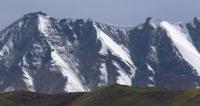
Kichik-Alai ridge.

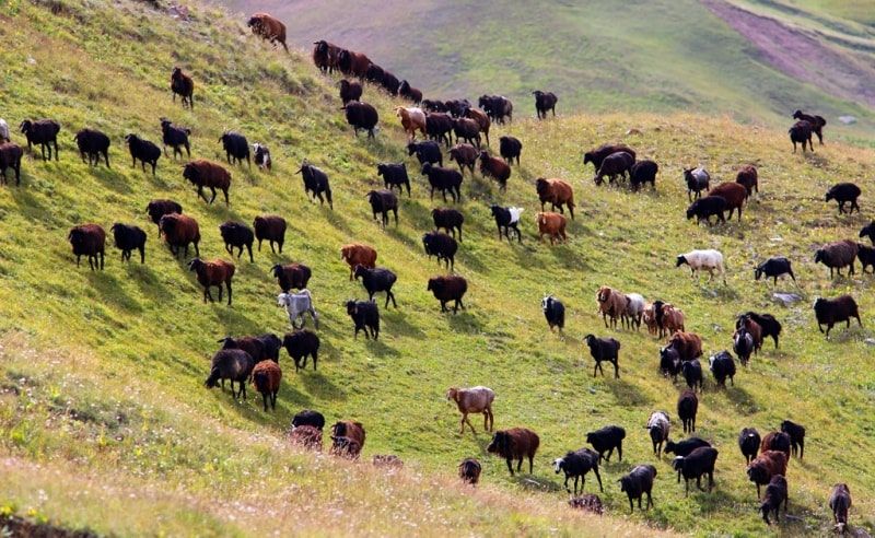
Great Silk Road on Southern Kyrgyzstan.
“Every dreamer knows that it is entirely possible to be homesick for a place you've never been to, perhaps more homesick than for familiar ground”
Judith Thurman.
Destinations and routes in Osh region.
Kichik-Alai mountain range is located in southern Kyrgyzstan in the Osh region, between the Ferghana and Alai valleys. In the south, Kichik-Alai borders on the Alai Range, to the south of which is the Alai Valley. In the eastern part, north of the Alai ridge, parallel to it, between 72 'and 73' east longitude and 40’10' north latitude, the Kichik-Alai ridge extends 80 kilometers from east to west.
From the first peak in the northeast of Shankol, 4630 meters above sea level, the Kichik-Alai ridge turns south, including the peaks of Jalan-Kanysh, 4426 meters above sea level, Kumbel, Pervomaiskaya, Surtoo and the beautiful Kurgan massif beyond the homonymous pass.
Further, the ridge turns to the south-west and includes a wide massif of Djoljilga, 4545 m. a. s. l. with its northern Osh spur. To the west of the massif, behind the eponymous pass in the ridge, there is a wide, heavily indented massif, including the peaks of the Chelyabinsk Rabocjiy, the Legendary Magnitogorsk and Jyrty, with a branched southern spur of Tavria and a long northern Karagoy spur.
Next, behind the rock tower of the Zhashtyk peak, 4560 meters above sea level with its southern spur in the west, stands a group of peaks of Kyrgyzstan with the Main peak in the southern spur and a long branched northern spur Suychikty.
Further, the ridge goes west to the Isfayramsay River, including dozens of peaks from 4,500 to 4,950 m. a. s. l. with numerous northern spurs.
Peaks and gorges located west of the massif of Kyrgyzstan were not visited by climbers. North of the Kichik-Alai ridge, parallel to it, through the peak of Jalan-Kanysh, a short, heavily destroyed scree of the Northern Kichik-Alai ridge with the Bloknaya peaks, 3924 m. a. s. l., Kirchiga, Andijan in the west and numerous simple peaks in the east stretches.
The southern boundary of the ridge runs along the rivers East Kichik-Alai and Western Kichik-Alai, the sources of which are ice-snow slopes lying under the Kichik-Alai lintel connecting the Kichik-Alai ridge with the Alai. The rivers West and East Kichik-Alai feed on numerous streams flowing from the southern side of the Kichik-Alai ridge and from the northern side of the Alai along which they flow.
The East Kichik-Alai River, merging with the Dzhiptyksu River, forms the Akbura River, which is the eastern border of the Kichik-Alai Range. The western border of the ridge runs along the Isfayramsay River, into which the Western Kichik-Alai River flows.
Southern short ridges and spurs of the ridge, including one or two peaks, descend to the Kichik-Alai rivers. Numerous long branched spurs extending from three to tens of peaks extend north from the ridge. Spurs form beautiful gorges with wide juicy pastures in the upper reaches and juniper forests not yet cut down in the lower reaches.
Glaciers lying in the upper reaches of the gorges feed a large number of mountain streams and rivers. Merging, they form the rivers Shankol, Kirghizata, Chachme (Chili), Chilek, Arabaksay and Abschirsay, carrying their waters together with Akbura and Isfayramsay to the Ferghana Valley.
The crest of the Kichik-Alai ridge is located in the latitudinal direction north of the Alai ridge in its eastern part. Starting south of the city of Osh, the ridge goes south by a low grassy, then talus ridge, with talus and light destroyed rocky peaks and approaches one of the main (in height) peaks of the Shankol ridge 4630 m. a. s. l.
Shankol is the first climbing peak located in the northeast corner of the Kichik-Alai ridge. From Shankol, the ridge ridge goes southwest to the Kumbel peak and beyond it and the Kurgan pass, 3871 m. a. s. l., approaches the Pervomaiskaya peak.
Further, behind the wide talus saddle of the Kumbel pass, 3950 meters above sea level, it rises in a talus slope to the light ruined rock tower of Surtoo peak. Behind it and the Surtoo talus pass, 4050 m. a. s. l. in the ridge, stands one of the main mountain climbing areas in the Kurgan Gorge - Kurgan with combined ST-5A routes of complexity categories.
Further, the ridge ridge gradually turns west and through the Zwilling ice pass, 4150 m. a. s. l., approaches the Dzholdzhilga massif with the pass of the same name - 4180 m. a. s. l. in the southwest. Osh spur leaves from the massif to the north.
To the west of the Dzholdzhilga pass, a very rugged ridge ridge with peaks slightly rising above the numerous gendarmes of the peak Chelyabinsk Worker with the northern Karagoy spur and the Legendary Magnitogorsk with the southern spur Tavria comes to the Dzhyrty pass - 4300 m. a. s. l., to the west of which the main technical mountain climbing peak is , by the north-western wall of which routes 5B of difficulty category are laid.
To the west of Dzhirty leaves a long rocky ridge with numerous obstacles, a ridge ridge with the peaks of Zhashtyk. To the west in the ridge are located with ice-rocky ridges and slopes, a group of peaks of Kyrgyzstan, from which the ridge descends to the pass Riga - 4200 m. a. s. l.
Behind the pass in the ridge rises one of the highest peaks of the ridge - Sakharov, the westernmost peak. To the north of the pass of Riga the spur Suychikty leaves. In the central and western part of the Kichik-Alai ridge, the peaks are mostly nameless, having only elevations.
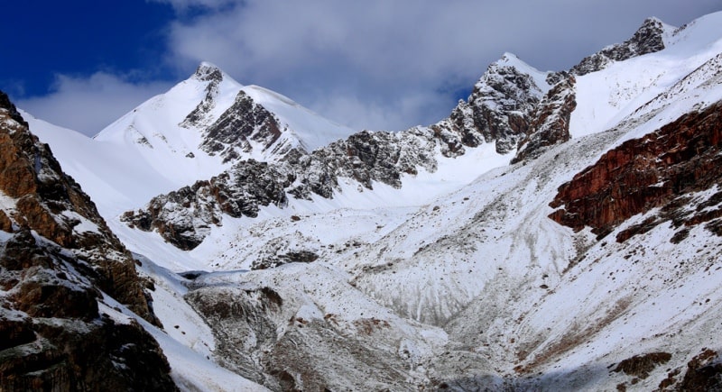
The greatest glaciation in the central part of the ridge, where the length of the glaciers reaches several kilometers. In the eastern and western parts of the ridge, glaciers mainly lie on the slopes of ridges only on the north side and in small gorges, mainly valley glaciers almost completely covered by moraine deposits.
Passes through the crest of the Kichik-Alai Range on the north side are snow-ice, on the south - scree. The approaches to them from the north side along the gorges are simple and pass, as a rule, along pack paths. On the south side, passage along some gorges is complicated by difficult passable canyons.
From the north side, routes from 1 B to 5B of difficulty category with sections of the 6th difficulty category were laid to the tops of the main ridge. There are practically no routes on the south side. Long screes or heavily destroyed ridges and numerous buttresses descend from the south side of the ridges and peaks of the ridge, from which scree slopes descend into the gorges.

Authority:
A.F. Naumov. "Mountain Climbing Ecyclopedia." Volume 1. “Pamir-Alai. Kichik-Alai Range. ” Moscow Infoline 1995.
Photos by:
Alexander Petrov.