


![]()
You are here
Kobdinsky reserve.
Botanical Tours in Central Asia.
“Nature is a friend of man. And you need to be friends with a friend.
People cannot live without clean air
clean water, fresh greenery, sunlight,
even without communication with animals and birds.
These are our countrymen, we live with them on Earth.
And every life requires attention and respect ..."
N. Sladkov.
The history of tulips of Kazakhstan.
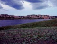
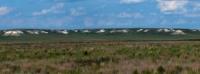
State integrated nature reserve "Kobdinsky" is located in the Kobdinsky district of Aktobe region. The motives for organizing the Kobdinsky integrated nature reserve were the preservation and protection of natural complexes and reference sites of preserved grass and feather grass steppes, unique forest pegs of the Podural plateau, shallow old women with wood-tugai thickets on the Ilek and Ulken Kobda rivers as favorable sites for rest on the span and nesting of waterfowl and near-water birds, habitats of plant and animal species.
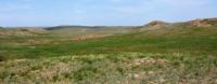
The relief is slightly inclined by the Podural plateau, the interfluve of the Ilek and Ulken Kobda rivers with old people, channels, developed river valleys with two floodplains and two accumulative terraces. The interfluve surface is slightly wavy, sometimes hilly.
Ridges, ridges and dome-shaped hills reach a relative height of 50-60 m. Absolute elevations from 100 to 200 m. The climate is sharply continental: mid-January temperature is -17-18 ° C, mid-July temperature is +21 + 22 ° C, average annual temperature air +1.5 + 2.5 ° C.
The sum of temperatures above + 10 ° C is 2400 - 2700 °; the average annual rainfall is 260 - 280 mm, the frost-free period is 140 - 160 days; hydrothermal coefficient 0.7 - 0.8; moistening coefficient - 0.35 - 0.45.
The average annual wind speed is 4.5 - 5.5 m / s, north-west winds prevail. Surface water: the Ilek river with a tributary of Ulken Kobda has snow and ground nutrition, which is clearly expressed in the flow regime.
The rise of spring flood levels is intense. Within 3 to 10 days, the water level reaches its highest height and lasts no more than 3 days, then an intensive decline begins within 4 to 12 days. In early May, a steady low water sets in. The highest levels on the rivers are observed in the first days after the ice drift.
The excess of the highest levels above the pre-spring level is usually 1 - 3.5 m, in high-water years it reaches 5 m. In the spring flood passes 80 - 90% of the annual flow. The flood passes mainly by one pronounced wave, then a low low water sets. In winter, the river freezes.
The opening of rivers is observed at the end of March - the first half of April and is usually accompanied by ice drift (1-3 days). 5-8 days before hiding, water appears on the surface of the ice under the snow. The average mineralization of water during floods is 0.2 - 0.4 g / l, and in the summer low water it rises to 0.7 - 0.9 g / l.
Groundwater occurs in the Upper Cretaceous aquifers, sand-gravel and fissured marl-Cretaceous sedimentary rocks. The chemical composition of the waters is variegated, mineralization from 1 - 1.5 to 5 - 7 g / l, the cost of water points 1 - 2 l / s.
Depth of 10 - 30 meters and more. Water of alluvial deposits of the Ilek and Kobda valleys is widespread. Ground water lies from 0.5 - 5 m in floodplains and on lower terraces, up to 15 - 20 m on high. The alluvium of the Ilek valley is most watery.
Mineralization of water does not exceed 1 g / l, the composition is mainly bicarbonate, bicarbonate-sulphate calcium or calcium-sodium. The soil cover is represented by dark chestnut ordinary, solonetzic soils with a high humus content and a significant content of gross forms of nitrogen and phosphorus.
In depressions of the plains and on the upper river terraces, saline soils are widespread. In the valley of the river. Ulken Kobda developed alluvial meadow soils with a humus content of up to 4%. Meadow soils are developed in narrow strips, often intermittent, several tens or hundreds meters wide.
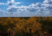
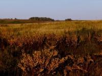
The thickness of the humus horizon ranges from 30 to 60 cm. The vegetation cover is represented by red feather grass forbs, mixed grass steppes with a predominance of feather grass. In depressions, floodplains, and elders, meadow-type vegetation is common.
The fauna is represented by steppe and tugai species. From mammals live wild boar, fox. The avifauna is represented by numerous waterfowl and near-water species: gray goose, ducks, gray crane
Authority:
Natural resources of Aktobe region. Ecoproject LLP. 216 p.
Photos
Alexander Petrov.