


![]()
You are here
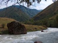
Kurmenty river in “Kolsai Kolderi” park.
Walking tours in Kazakhstan.
"Observe nature and follow the path she shows you."
Rousseau Jean-Jacques.
Mountain excursions in Kolsai Kolderi park.
The sources of the Kirmenty river are located at an altitude of 3319, and the mouth is at an altitude of 1527.8 meters above sea level, the river flows down the northern slope of the Kungei Alatau ridge, and is located on the territory of the Kolsai Kolderi natural park in the Kegen district of the Almaty region.
6.5 kilometers downstream after the Taldy River, the Kurmenty tributary flows into Chilik. The length of the river is 22.5 kilometers. Throughout its entire length, the river has only three small nameless tributaries on the right, only two tributaries on the left.
From the source to the village of Kurmeti (kaz. Urmeti), the river is called Kurmenty, after the village of Kurmeti, the river is called Kurmekty. After the Kurmeti settlement, the river is divided into several branches. The river originates from Lake Kurmenty, located at an altitude of 3319 meters above sea level on the northern slope of the Kungey Alatau ridge.
The length of the stained, flowing lake from south to north is 573 meters, width is 247 meters. The perimeter of the lake is 1452 meters, the area is 103,226 square meters. The lake lies 750 meters northeast of the Kurmenty Pass, located in the main ridge of the ridge at an altitude of 3445 meters above sea level.
Geographic coordinates of the Kurmenty River: N42 ° 59'10.36 "E78 ° 16'49.39"
Authority and photos by
Alexander Petrov.