


![]()
You are here
Kyzyltas mountains.
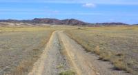
Trip to Kyzyltas mountains from Karaganda.
“In the mountains they do not walk with their feet, in the mountains they walk with their heads.”
Folk wisdom.
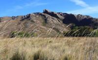
Nature in Kyzyltas mountains.
Kyzyltas Mountains are located in the central part of the Kazakh uplands, 90 kilometers southeast of the Karkaraly Mountains, 210 kilometers north of the city of Balkhash in the Karaganda region. The Kyzyltas mountain range consists of folded structures that stretch from the northwest to the southeast for 150 kilometers, the maximum width of the massif, in the central part, reaches 115 kilometers.
The highest elevation of the massif is located in the northeast, this is Mount Karakus in the mountains of the same name, 1328 meters high above sea level. The second highest mountain is Mount Kaushoky, 1283 meters above sea level, located northeast of the Otar Mountains and northwest of the Baubektau Mountains.
The third highest mountain in the Kyzyltas mountains is Mount Kurpetai, located in the southwest of the massif with a height of 1266 meters above sea level.
In the northern part, the Kyzyltas massif consists of several low mountains: the Zhaksy-Karazhal mountain with a height of 1088 meters above sea level, the Shokpar mountains with the dominant Makat mountain, meters above sea level, the Kotantau mountains with the dominant Shokpar mountain, 1106.6 meters above sea level, the Kyzylzhal mountains with a dominant Akshoky mountain 959 meters above sea level, Egiztau mountains with a dominant mountain 1048 meters above sea level, Karashoky mountains with a dominant mountain 1033 meters above sea level, Teladyr mountains mountains with a dominant mountain 917 meters above sea level, Belkoitas mountains with a dominant Karagash mountain 1077 meters above sea level, the Shukyrbay mountains with a dominant mountain 1009 meters above sea level, the Uzynzhal mountains with a dominant mountain 859 meters above sea level, the Zhaman-Karazhal mountains with a dominant mountain 1090 meters above sea level, mountains Atbel with a dominating Divan mountain 1151 meters above sea level, Bidaytas mountains with a dominating mountain 1069 meters high ov above sea level, the Tolembay Mountains with a dominant mountain 1076 meters above sea level, the Tolagay Mountains with a dominant mountain 1122 meters above sea level, the Baigushuk Mountains with a dominant mountain 1215 meters above sea level, the Karakus Mountains with the dominant highest mountain of the massif - Karakus with a height of 1328 meters above sea level, Karabaily mountains with a dominant mountain 1139 meters above sea level, Mynbulak mountains with a dominant mountain 1225 meters above sea level, Zhyngyztau mountains with a dominant mountain 1152 meters above sea level.
In the central part, the Kyzyltas massif consists of the following low mountains: the Otar Mountains with a dominant mountain 1159 meters above sea level, the Saryzhal Mountains with a dominant mountain 1152 meters above sea level, the Arshaly Mountains with a dominant mountain 1058 meters above sea level, the Berkara Mountains with a dominant mountain with a height of 1135 meters above sea level, the Kyzyltas mountains with a dominant mountain Esav 1060 meters above sea level, the Kushoky mountains with the second highest peak of the massif, the mountain of the same name with a height of 1283 meters above sea level, the Baubektau mountains with a dominant mountain 1142.9 meters above sea level sea level, Kalibek mountains with a dominant mountain 1074 meters above sea level, Karamola mountains with a dominant mountain 1024 meters above sea level, Saryzhal mountains with a dominant mountain 1175 meters above sea level, Kemershi mountains with a dominant mountain 1088 meters above sea level.
In the western part, the Kyzyltas massif consists of the following low mountains: Dauna Mountains with a dominant mountain 983 meters above sea level, Kokmanta Mountains with a dominant Besshoky Mountains 1110 meters above sea level and Amantai Mountains 925 meters above sea level, Kyzylzhal Mountains with a dominant mountain 942 meters above sea level, Sarytoganbai Mountains with a dominant mountain 1031 meters above sea level, Azbay mountains 962 meters above sea level.
In the southern part, the Kyzyltas massif consists of the following low mountains: Karatoganbay Mountains with a dominant mountain 1090 meters above sea level, the Karatoganbay Mountains with a dominant mountain 1140 meters above sea level, the Kurpetai Mountains with a dominant mountain 1227 meters above sea level, the Manet Mountains with a dominant 1082 meters above sea level, Tulumbay Mountains with a dominant mountain of 1073 meters above sea level, Tolebay Mountains with a dominant mountain of 1077 meters above sea level, Ushtagan Mountains with a dominant mountain of 1015 meters above sea level, Zhaopak Mountains with a dominant mountain of 1077 meters above sea level 864 meters above sea level, the Kokalasakal mountains with a dominant mountain 834 meters above sea level, Karaoba Mountains with a dominant Akshoky mountain 909 meters above sea level, Ulken-Kaaoba Mountains with a dominant Akshoky mountain 874 meters above sea level, Momny Mountains with a dominant mountain 990 meters above sea level, Tortgul Mountains with a dominant mountain 847 meters above sea level seas.
In the southeastern part, the Kyzyltas massif consists of the following low mountains: Saiman Mountains with a dominant mountain 1039 meters above sea level, Shongal Mountains with a dominant mountain 1098 meters above sea level, Kyzzyladyr Mountains with a dominant mountain 1025 meters above sea level, Bylnyldak Mountains with a dominant mountain Naimanbay 980 meters above sea level, mountains Zhundykargan with a dominant mountain 1016 meters above sea level, Kyzzyladyr Mountains with a dominant mountain 1025 meters above sea level, Saiman Mountains with a dominant mountain 1039 meters above sea level, Akirek Mountains with a dominant mountain 994 meters above sea level.
Among the Hercynian folded structures in the center of the Kazakh upland region, the Kyzyltas mountains are the highest in Central Kazakhstan, with the Aksoran massif rising in the south to a height of 1566 meters above sea level.
Like Ulytau, they are located in a semi-desert latitudinal zone. Together with the surrounding small hills, lying at a level of 700 - 900 meters above sea level, the Kyzyltas mountains "form the main orographic and water-separating core of Central Kazakhstan" (Gvozdetsky, Nikolaev, 1971, p. 189).
Elevated insular mountains formed by granite intrusions are clearly distinguished here among the mountainous and hilly semi-desert. As a result of arid denudation, granite rocks are exposed here too, bushes and sods of petrophytes are observed only in crevices, and on rough clastic screes - thickets of Cossack juniper.
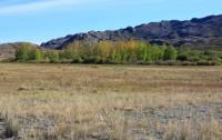
At the foot of the mountains, along streams and near groundwater outlets, willow, aspen and birch forests grow green. On the northern slopes of the Kyzylrai granite mountains, areas of pine woodlands have been preserved.
There are deposits of polymetallic ores in the region. The hydrography of the mountains is represented by numerous streams that are filled with water from spring to mid-June, subsequently many of them dry up.
In the northern part of the Kyzyltas mountains there are a large number of small rivers and streams: Aiyrtas, Bidayik, Tokuldak, Karamola, Uzynbulak, Baikaska, Keregetas, Karashoky, Konyrtobe, Basbaldak (Aktobe), Manaka, Sakalbay.
In the central part of the Kyzyltas mountains there are small rivers and streams: Sherubainura, Zhalpak, Keregetas, Zhamankolynas, Turagash, Ushbulak, Karamola, Akkezen, Karasu, Aktas, Koktal, Sarym, Kozhagulozek, Karagash, Karamendy, Koykalgan, Egizkoytas, Turagash, Zhamankolynas.
In the southern part of the Kyzyltas mountains there are small rivers and streams: Tulkili, Shalshiy, Sirektal, Shubarazek, Zhiembay, Altybay, Nurtaiozek, Ushtarau, Karasai, Madeni, Uzynbulak, Karabidayik, Apakai, Keruenbulak, Taldyespe,
The rivers are fed by snow, a few springs are located in the northern part of the mountain.
Geographical coordinates of Kyzyltas mountain range: N48°44'34.93" E74°32'25.81"
Authority:
Gvozdetsky N.A., Golubchikov Yu.N. "Mountains", series "Nature of the World". Moscow, Thought, 1987.
Alexander Petrov.
Photos by
Alexander Petrov.