


![]()
You are here
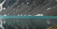
Lake Kashka-Su. Kyrgyz ridge.
Walk to Kashka-Su gorge.
«Unripe rains lurk in the clouds
And it's too early to sum up the results -
These clouds have blizzards ahead
Yes, and we have roads and roads.»
Yuri Vizbor. "Footprints". 1962.
Waterfalls on Kashka-Su river in Kyrgyz Ala-Too mountains.
The Kashka-Su moraine lake is located at an altitude of 3531 meters above sea level in the upper reaches of the Kashka-Su gorge on the northern slope of the Kyrgyz Ala-Too ridge in the Alamudun district of the Chui region.
The length of the lake from the south-east to the north-west is 143 meters, the greatest width in the southern part of the lake is 50 meters. The perimeter of the lake is 352 meters, the area is 3349 square meters.
410 meters south of the lake there is a small Kashka-Su glacier, 470 meters long, which is located on the northern slope of the gorge of the same name. The glacier has a perimeter of 1407 meters and an area of 76,094 square meters.
The lake receives its main filling from the Kashka-Su glacier. The western source of the Kashka-Su River flows from the southern part of the lake. In the upper reaches of the glacier, in the meridional ridge of a small ridge, there is one of the most frequently visited peak, Komsomolets, 4204.1 meters high above sea level.
At 1.1 kilometers to the west and a little to the south of the lake, there is the Pioneer peak, 4021 meters above sea level.
Geographic coordinates of the Kashka-Su River: N42 ° 38'31.31 "E74 ° 31'44.56"
Authority and photos by
Alexander Petrov.