


![]()
You are here
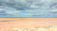
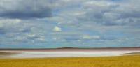
Lake Kobeituz.
Trip to Kobeituz lake near Ereimentau town.
“She is everywhere; it touches the past and prepares the future; it flows under the poles and is present at high altitudes. If there is something truly mysterious on this planet, it is water."
Lauren Eisley.
Natural sights of Akmola region.
Salty, drainless lake Kobeytuz (Kazakhstan Kobeytuz) is located at an altitude of 253 m. a. s. l., located in the southeast of the North Kazakh Plain, in the Teniz lake depression between the Olenta and Sileti rivers, 33.1 kilometers northeast of the city Ereymentau, 17.8 kilometers northwest of the village of Ulenty, 3.1 kilometers east of the bitter-salty Lake Teniz in the Ereymentau district of the Akmola region.
The area of the lake is 7.4 square kilometers, the length is 3.5 kilometers, the maximum width in the southern part reaches 3.2 kilometers. The length of the coastline (perimeter) is 10.59 kilometers. The catchment area is 247 square kilometers.
The banks are flat, the southern ones are rugged, the bottom is muddy, and there is black healing mud. The lake is fed by spring snowmelt and groundwater. Kobeytuz water is salt brine. In summer, good quality table salt up to 30 cm thick is formed on the surface of the lake.
Periodically the lake turns pink. It is believed that the pink tint to the water is given by the presence of the algae Dunaliella salina. The lake is a tourist attraction in the Akmola region. In the summer of 2020, the Department of Natural Resources and Environmental Regulation of the Akmola Region announced a competition for the separate use of Lake Kobeytuz for a period of 49 years.
Geographic coordinates of Lake Kobeytuz: N51°44'31 E73°32'18
Authority:
Alexander Petrov.
Photos by:
Almas_Tangytuly