You are here
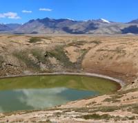
Lake Tentek-Sai. Dzungarian Alatau.

Visiting lakes in Dzungarian Alatau.
“Great things are done by grandiose means. Nature alone does great things for free.”
Alexander Ivanovich Herzen.
Excursions and routes in mountains of Dzungarian Alatau.
Moraine, flowing lake Tentek-Sai is located at an altitude of 3448 meters above sea level, is located in the upper reaches of the river of the same name, on the southern slope of the Dzungarian Alatau ridge in the Eskeldin district of the Almaty region.
In the south, east and west of the lake there are mountains and ranges that are part of the Dzungarian Alatau. The lake is located in the northwest of the latitudinal Arasan mountains, in the east of the Zhaman-Kol ridge, in the northeast of the Koitas mountains and in the northeast of the Tiliktor mountains.
A stream flows out of the southwestern end of the lake, which after 4.4 kilometers becomes a right tributary in the main channel of the Tentek-Sai river. This tributary is the westernmost component of the Tentek-Sai basin.
An unnamed peak 3716 meters above sea level is located 1 km northeast of the lake, which closes the glacial cirque. The perimeter of the lake is 921 meters. The length of the lake from southwest to northeast is 315 meters, the width in the central part of the lake is 134 meters.
The lake is located in a glacial cirque, which is closed by a moraine in the upper part. This basin is in the form of an amphitheater, closing the upper end of the glacial valley. In the basin, 4 moraine lakes are concentrated, including the main, largest and longest of them - Tentek-Sai.
90 meters below, to the south of the lake, there is another small flowing, moraine lake No. 1 located at an altitude of 3401 meters above sea level. 600 meters to the south there is a moraine, flowing lake No. 2 located at an altitude of 3298 meters above sea level, which is connected by one channel with Lake Tentek-Sai.
At 515 meters southeast of the lake there is a moraine, flowing lake No. 3 located at an altitude of 3368 meters above sea level. This is a long lake, stretched from the southeast to the northwest with a length of 200 meters.
Tronova Glacier, 5.4 kilometers long, is located 3 kilometers to the east of Lake Tentek-Sai. The upper limit of the glacier is located at an altitude of 3727 meters above sea level. The tongue of the Tronov Glacier is located at an altitude of 2970 meters above sea level. The glacier belongs to the basin of the Kora River.
Geographic coordinates of Lake Tentek-Sai: N44°53'01.15" E79°20'16.31"
Authority and photos by:
Alexander Petrov.


