


![]()
You are here
Lakes of Fany Mountains.
Travels on Fany Lakes.
"Water! You have no taste, no color, no smell, you cannot describe you, you enjoy you, not understanding what? you are. You are not just necessary for life, you are life. With you, bliss spreads throughout your whole being, which cannot be explained only by our five senses. You return to us the strength and properties on which we have already put an end to it. With your mercy, the dried up springs of the heart are again opened.
You are the greatest wealth in the world, but also the most fragile you, so pure in the bowels of the earth. You can die near the source if it contains an admixture of magnesium. You can die a stone's throw from the salt lake. You can die, even though there are two liters of dew, if some salt got into it. You do not tolerate impurities, you can not stand anything foreign, you are a deity that is so easily frightened away ... But you give us infinitely simple happiness"
Antoine de Saint-Exupery.
Study tours in Fany Mountains.
The intricate crossing of ridges and the activity of former glaciers that filled moraine ramparts created the conditions for the formation of many lakes in secluded gorges and mountain circuses. In the Fan Mountains, there are up to 30 lakes with cold transparent water, born on the snowy fields of the peaks.
The lakes are located on the pedestals of ancient and fresh moraines, formed as a result of melting and retreating glaciers. Only a few of them (like Turquoise or Akhbasher) are formed in the depressions of snow-gravelly slopes.
The dam of Lake Bolshoye Allo consists of two layers: the base is an ancient moraine, and from above it was blocked by a grandiose obstruction. By now, many lakes have greatly decreased in size due to a decrease in water inflow (Zierat) or a breakthrough of obstructing moraines (Karakul).
On Lake Iskanderkul, several horizons are noted above the current water level, crossing the coastal slopes in parallel lines and marking the previous position of the coastline. It can be assumed that Lake Iskanderkul broke through its moraine several times.
There were more lakes before. Many pre-existing lakes are now represented by dried-up depressions, for example, dry bottoms above the Alaudin lakes. On Yagnob, above the dip, the bed of the former lake is clearly visible, which is gradually covered by pebble deposits.
The Sarytoga and Pasruda valleys were large lakes. There are often systems of two lakes (Dyushakha, Zierat, Kulikalon, Chukurak, Pushnovat). Water from the upper lake overflows into the lower one, and if the level of the upper one falls, then the flow stops, and the lower lake either decreases in size or temporarily dries up.
Small Mutnoye Lake, connected by a channel with the upper, Big Mutnoye Lake, experiences strong level fluctuations. The duct is narrow and shallow. In addition, Maloye Mutnoye Lake has an underground runoff. Sometimes it narrows or clogs up, and the lake begins to arrive quickly.
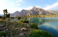
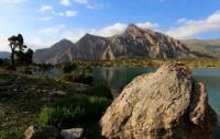
By the end of summer, the level of lakes decreases, and such as Ancantad dry up completely. Lake Iskanderkul in 1964, at the beginning of summer, increased its level so much that it flooded the coastal path. Iskanderkul is the largest lake in the Fany Mountains, widespread at an altitude of 2200 meters above sea level.
Its shores are picturesque, the lake is surrounded by mountains on all sides, and the snowy peaks are reflected in its calm surface. Over the shoulders of other peaks, he looks into the lake Kyrk-Shaitan. Despite the abundance of water, the landscape is dry.
Little greenery. Only at the mouths of three rivers do the groves darken, and the rest is dominated by the slopes of light tones. Bushes of wild rose, barberry, sea buckthorn stretch along the coast in a narrow strip. In winter, Iskanderkul is covered with ice, but a stream of flowing water remains in the middle part.
The water in the lake is cold, however, you can swim near the shore and in closed bays in summer. The color of the water is bluish-green, slightly cloudy. The depth reaches 72 meters. There is a very small fish in the lake - char.
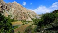
Near Iskanderkul, in the gorge of the Serima River, there is a small lake Zamin-Mulla, or Zmeinoe, as tourists called it because of the abundance of snakes in the water. The Serima gorge near the Serpentine is all in the forest, the southern shore of the lake is steep, and on the northern shore there is a vast clearing with large old trees.
Unfortunately, the northern low coast is damp and even swampy. Along the Serima gorge you can take a pleasant walk along the trail, especially since there are many small sweet cherries here in summer. At the top, the gorge shrinks and turns into a canyon.
To admire the canyon and waterfall on Serim, you need to make your way along the riverbed through a dense thicket of vegetation. The second largest lake of the Fany Mountains - Kulikalon (which means a large lake) is located at the western edge of the large Kulikalon depression at an altitude of 2800 meters above sea level.
It is warm here, a juniper forest grows, you can swim in the lake. The northern coast of Kulikalon is whimsically indented, secluded coves go deep into the shores, rocky capes divide the bays, a winding strait separates a large green flat island protruding far into the lake.
To the southern end, Kulikalon narrows, the rocky slopes of the lateral spurs come close, and then the black walls of the Western Fan Range rise, white-green ice sparkles on the ridge. A short channel separates the Big Kulikalon from the Small, which is a small bowl.
Lake Kulikalon is the last link in the chain of lakes in the Kulikalon Basin. Their waters are brought by a river that flows into a lake on the northern shore. The second river flows into the lake at its southern end. The drain from the lake is underground, through the moraine.
Having pierced the moraine, the Artuch River appears. On the shores of the lake in summer there are koshi-aguli of the underlying villages. Marinka fry have recently been released into the lake. The fry took root, and the lake became fishy.
From Kulikalon you can take interesting walks up the northern river. Here, among the moraine hills, there are s juniper forest is still preserved on the banks. Dyushakh are a system of two lakes connected by a channel with a long isthmus separating them.
The difference in lake levels is small. From the shores, a panorama of nearby glaciers, reflected in the water, opens. Along with the juniper, a mountain ash climbed here. A convenient path leads to the lakes. From here it is easy to take an excursion to the Maria glacier, but it is not recommended to come close to the icefall, as the upper ice may collapse at any time.
Descending from the rampart of the old moraine, the trail comes to the Bibi-Jonat lake, stretched out in length and surrounded by forest. The trail to the Laudan pass runs along the eastern slope. From here you can quickly get through the Alaudin Pass to the Alaudin Lakes.
Down from the lake, through a long footbridge, there is a trail to Lake Kulikalon. The next step, where Lake Bibi-Jonat overflows, will be the vast lake Kulisiyokh (black lake). Its banks are overgrown with impassable thickets, and the water is dark, mysterious.
The bottom is covered with long dark brown algae. Making your way further among the stones and trees, you can go to another lake with intricate outlines of the shores, with stone islets, bays and capes, where large black currants grow.
This is the Forest Lake, the last one before Kulikalon. It is good to observe the Kulikalon Basin by climbing the light meadow peak Fluorite. On both sides, lakes shine in the forests, the surface of Kulikalon spreads below, Ruzeravat summit rises in front, and a snow-ice ridge behind.
In the same area, through the forest Chukurak pass, you can get to the Chukurak gorge. In the same gorge, you can walk from below along a well-developed path from the gorge of the Artuch River. There are three unique lakes in the Chukurak gorge.
The lowest lake (Chukurak) is located above the mouth of the gorge, which blocks the exit to the north. Here, at the foot of a grandiose rocky bastion, under the slopes densely overgrown with dark green juniper, an oblong lake, greenish in the daytime and blue in the evening, finely crushes under a weak breath of a gentle breeze.
The lake is double, cascading. From the upper, large lake, water overflows into the lower, small one. The inflow of water by the end of summer drops sharply and the large lake becomes very shallow, and the small one dries up altogether.
The streams of three gorges, fed by snowfields, flow into the lake. They dry up when the melting of the snow above ends. The Chukurak river flowing out of the lake also gradually changes its regime and, finally, completely disappears among the stone rubble a little below the lake.
Climbing from Lake Chukurak along the path to the left, you can go to a small lake Beloye, the shores of which, as the water decreases, are covered with a white coating of salt. This lake, fed by a stream from the upper reaches of the Chukurak pass, acquires the character of a non-flowing one.
In it, aquatic bog vegetation develops densely. Wide leaves of water lilies spread out on the surface of the water. The water is very warm, with a swampy flavor, and loses its ability to play with bright colors. From here, the trail leads south to Lake Zierat, height 2790 meters above sea level.
The path to it goes first through a forest, and then the juniper thins, the river hides under stones, light streams of wide talus roll down to the path, the ridges of the ridges become closer and more accessible. The Tajiks gave the gorge the name "Resort".
The vegetation receding before the highlands, the lifelessness of the rocky slopes from which the whistle of snowcocks can be heard, and the gloomy wall of Sary-Shah in the south in front do not fit the festive word “resort”.
The most beautiful lakes are Alaudins (Chapdara). They belong to the Pasrud river system. It is one day's journey from the village of Pasrud. From the mouth of the Chapdara, a good path goes up this river. In the distance, the peaks open: the stone pillar of Adamtash, the strict cone of Mirali and the distant Maria.
A little more, and on the left above the forest, Chapdara rises like a wall. The trees move aside, and a calm lake rises in front of our eyes, into the depth of which the Chapdara peak goes to its entire five thousandth height.
When viewed from a height, mountain lakes are always blue or blue. Their color is borrowed from the sky. But the color of the Alaudin lakes is born inside and wins in a dispute with the sky. Sixteen and a half meters deep, and not a single grain of sand suspended in the water.
A five-kilometer underground stone filter reliably protects the purity of the lake. They cannot muddy its underwater springs, gushing under the southern coast, and the noisy stream that rushed into the lake, bursting out from under the colossal stone plume of Chapdara, is crystal clear.
The trail runs along the western shore of the Big Alaudin Lake. Here, in the southwest corner, there is a green lawn where you can pitch your tents. On the other side of the lake, a peninsula juts out into the lake with a curved stone hook.
A river emerges from the Big Lake, further dividing. One branch flows into the Middle Lake, and the other disappears into the heaps of moraine, so that later it can break out in effervescent ribbons below the green slope above the Lower Lake.
The sources of all Alaudin lakes are blocked by a stone dam. Water overflows from step to step, and the level of the lakes knows no fluctuations. To the east of the Big Lake lies the Eastern one, fed by a stream flowing from Chapdara.
The clarity, clarity and colors are the same as for the other three lakes, but this lake, off the beaten track, has a more secluded character. The drain of the East Lake is underground. There is no fish in the Alaudin lakes.
The gorge of the Alaudin lakes is facing north, from the south they are surrounded by a snowy ridge, and all around are the highest peaks with many glaciers; nevertheless, their climate is warm, despite the significant altitude of 2,700 meters above sea level.
It often happens that there is bad weather higher up the gorge, it is raining or snowing, and it is clear and warm on the lakes, although only those who love a cold bath can swim. A popular tourist route passes through the Alaudin Lakes, and climbers begin their ascents to Chapdara and Chimtarga from here.
Another ancient terminal moraine overgrown with forest was erected over the Big Alaudin Lake, but, obviously, the glacier did not stay here for long. Moraine is small. Above her, the trail goes among rare juniper and grassy meadows, which were once the bottom of dried up lakes.
The walls of the western spur of Chapdara rise above the right side of the gorge, and under them water has found shelter. A small moraine lake was formed among the talus, surrounded by an aspen grove. The stream does not flow from it for long and soon buries itself in the moraine stones.
Above is another lake - Cold with greenish water smelling of melted snow. Ahead, the gorge is blocked by the first moraine rampart. Its crest is bared with large stone blocks, slabs and pillars. The easiest way he gets around from the west, under the wall of Adamtash, where there are some hints of a path.
The last juniper ends under the first shaft. At its foot, the round bowl of Lake Piala glistens. The stream that escaped from under the talus briefly looks into the lake and again goes into the dark depths of the stone placers; only far below the moisture breaks through the underground dungeon and comes out into the free light.
After the second shaft, the path becomes easier. The trail goes along the ridge of a yellow moraine, behind which there was once a lake. On the second, higher moraine, a stream rolls down from the Bodkhona glacier.
The glacier has no tongue and ends with a steep hump of the glacial body. On the glacier, one can observe glacial tables, large cracks. It is necessary to approach the ice tables carefully: the plate crowning the ice leg is often in a state of unstable equilibrium, can suddenly move out and crush the observer.
Glacial cracks often have a hollow dome inside, their edges are unreliable. In the depths, behind the glacier, from the foot to the top, Bodhona peak is visible. On the way from the second shaft to the third one, the first thing that catches the eye is the black skeleton of the Fagitar peak.
The third shaft is not difficult, even the path is visible here and there. Above it, behind the moraine fields, there are Mutny Lakes at an altitude of 3400 meters above sea level. The lakes of the double system have an underground flow.
They owe their existence to the terminal moraine, reinforced by rock falls. It got its name from the color of the water, which is cloudy with the products of the erosion of the glacier bed brought by numerous glacial streams.
The landscape around Mutnye Lakes is notable for its harsh grandeur. Here, as in the Alaudins, there are no merry meadows with flowers and forests warmed by the sun. Glaciers hang over the Muddy Lakes and clouds sow snow pellets, the peaks are very close, and even the proud Chimtarga does not seem at all inaccessible.
On the shore of Maly Mutnoye Lake there is a convenient place for a bivouac and an overnight stay. Despite the significant altitude, the nights are not cold here, and during the day in the sun you can walk in shorts and sunbathe.
If you climb the path up the Arg, you can go to the Anzac glade. Away from the path, closer to the slopes of the mountains, a lake is unexpectedly discovered, quiet, calm, largely hidden in the dark darkness among the trunks of trees standing in the water.
The lake is located at an altitude of 2500 meters above sea level and is called Ancantad. Its banks are bordered by dense grass. It doesn't look like a mountain lake. He belongs somewhere in the north, among the damp forests and meadows.
The spring and summer water of the mountain slopes, where the spots of snow are gradually melting, replenishes its bowl. The hotter the sun warms, the more water collects in the lake, flooding the meadow shores, and black tree trunks sink deeper into the water.
And by the end of summer, the flow of water will stop, and the lake will ascend to the peaks with light steam and again sink to its bed with the awakening of spring. Far at the top of the gorge, where Apr gets the name Kaznok, and even higher, where there is nothing except snow fields and protruding dark rocks, a high-mountain lake, nicknamed by tourists as Turquoise, will suddenly flash with a bright eye - a blue eye in a snowy desert.
It lives only 3 - 4 months a year, and the rest of the time it mysteriously slumbers under a deep snow cover and hardly knows people. The lake looks like a mountain flower, blooming in late spring and dying by the end of summer.
The trail along the Zindon river leads to the Small Allo lake. The trail goes on the right bank among thickets of birch, willow and sea buckthorn and on the rubble and talus is poorly distinguishable. Lake Maloe Allo is sometimes blue, sometimes green, with transparent water, small.
As in other cases, water, filtering through the rubble of insoluble rocks, acquires crystal clearness in the lake. Huge talus descend from the slopes. The mountains are gradually turning into ruins. The rate of destruction seemed insufficient, and a powerful force pushed the mountains from within, causing them to instantly shatter into pieces.
The river stopped, and a new lake was born in the mountains - Big Allo. Only after 5 kilometers the river squeezed out from under the blockage. The pack trail ends under this blockage. Rare juniper trees can still be found on the shores of the lake, and then there is a stone desert, turning into a snowy and icy desert, but in front of the lake, just below, there is a rose garden, where you can walk in the alleys of high rose hips.
And above, a cold wind sweeps over the top of Chimtarga. The Allo gorge is close, and the shores of the lake are rough. From the north - heaps of stone blocks, from the south and east - vertical walls of rocks going into the water, and only in front there is still a way through the gorge of the Left Zindon.
The trail goes around the lake on the right side of the gorge. In low water, the path is very simple and easy, the coast is shallow, and you can walk on the water. When the level of the lake rises, you need to walk along the rocks.
Above the lake, in the Left Zindon gorge, there are two more small lakes in pebble flat shores. Quite high, at a level close to 4000 meters above sea level, two Pushnovatsky lakes lie like the remnants of the former glaciation between the crown of the Pushnovat peaks and the Obborik peak.
The glacier is no longer there, it has melted, only snowfields feed the lakes. It is cold here, and during the night the lakes are covered with thin ice, which melts during the day. The way there goes from the Pushnovatskaya trail through a high moraine-obstruction, and the hollow of the lakes is gentle, among the pebbles, and the peaks of Dukdon are visible in front.
Authority:
"Fany Mountains and Yagnob". N.V. Paganuzzi. 1968. Moscow. Physical Culture Publishing House and sports.
Photos by
Alexander Petrov.