


![]()
You are here
Mausoleum of Botagay.
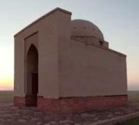
Photo tours on historical monuments of Akmola region.
“Tatagai, the ruins of a great city in Kirgis Kaisatsky Middle Horde, on the Nura River, which flows into Lake Kargaldzhin, from the mouth of this river about thirty versts. According to signs, this city was about ten versts away, and you can still see here quadrangular chambers, like a castle, so large that in the district there are three hundred sazhens. There is also one mosque, and a lot of ruined stone buildings. The Kirghis say that the Nagais lived here in the old days.”
Petr Rychkov. "The work of the imperial adviser of the Academy of Sciences Pyotr Rychkov." 1762.
Ancient mausoleums of Akmola region.
Mausoleum Botagay (also Bytygay, Tatagay, etc.; Kazakh Botagay kesenesi) - an architectural monument of the XI - XII centuries, located at an altitude of 341.6 meters above sea level, located in the central part of the ancient cemetery, 3.3 kilometers to the northeast from the settlement of Korgalzhyn, 1.8 kilometers from the right bank of the Nura River, 1.5 kilometers to the east and slightly north of the Dudarai stele, 3.2 kilometers to the south-west of the village of Abay in the Korgalzhyn district of the Akmola region.
The name of the mausoleum Botagay has different meanings, such as Batogay, Botakay, Butagay, Tatagay, Tatakay, Totogay. The local population pronounces Bytygay (kaz. Bytygay).
Legend of Botagai.
There is a legend recorded in the summer of 1974 from the words of a native inhabitant of the village of Korgalzhyn, Ermek Nurpeisov (1937 - 1995). According to legend, in ancient times there lived a skilled master builder, the giant Bytygay.
He was poor and lived only on his craft. Bytagai had such strength that he could jump over the Nura River with two logs in his armpits. One khan decided to build a mausoleum for himself during his lifetime and invited Bytygai for this.
He immediately began construction, and soon created a skillfully decorated mausoleum. The mazar was so huge that the shadow from it reached the river, which passed 1 kilometer from the building. Khan fell in love with the master for his skill.
After the construction of the mausoleum, Bytygay built a bridge across the river at the place that is now called the ford of Bytygay (kaz. Bytygay ötkeli). During the construction of the bridge, a misfortune happened: one of the beams collapsed and killed the master.
Khan grieved and decided to bury the master in the mausoleum that he built for him, so that his memory would be preserved forever.
Quadrangular structure with a dome 10.67 x 8.53 meters. Height 10.67 meters (according to Alexei Shakhmatov) or 9.24 meters (according to Ch. Valikhanov). Material - burnt brick. A dome 7 meters in diameter and 3.5 meters high was erected over an octahedral drum 1 meter high.
The main facade of the mausoleum and the inner walls are decorated with cubic patterns. The area around the mausoleum is lined with bricks.
Inspection of the mausoleum Botagai.
For the first time the name was put on the map of Russia in 1694 by the ambassadors F. Skibin and M. Troshin, during a visit to Khan Tauke. It consisted of 20 pages and was called "Kazakh horde". The appendix to the map says that the city of Botagay is located on the coast between Lake Korgalzhyn and the Nura River.
Many caravan roads that passed along the Great Silk Road intersect here. In 1762, a book was published in St. Petersburg. A Russian scientist who traveled through the Kazakh land wrote the following data about Botagai: “Bytygay is the remains of the great city of the horde of Kyrgyz-Kaisaks on the Nura River flowing into Lake Korgalzhyn.
According to the characteristics, it was ten kilometers away, and the local quadrangular buildings in the form of a palace were so large that they occupied three hundred fathoms. There is one mosque and collapsed stone buildings here.”
In 1816, I. Shangin examined the mausoleum and gave him a brief description, a description of the plan of the building and the front of the mausoleum. In 1825, adviser Demidov, in a note addressed to Alexander I about the resettlement of the border line of Siberia and Orenburg to Kazakhstan, wrote about the monument: “Among the salt lakes, Korgalzhyn is the largest, with a circumference of 300 kilometers. The Nura River, which used to flow into the Esil River, now flows into this lake. Nearby you can see the territory of the old arable land, which proves the fertility of these lands, and the brick ruins formed from the destruction of the old city, tell about the significant fine arts, which occupies a neighborhood of 15 kilometers. This suggests that not nomads lived in these parts, but an educated, literate people."
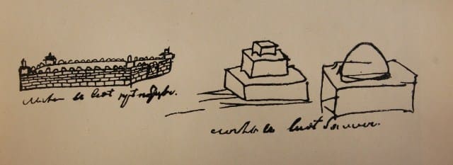
Since the 19th century, it has been repeatedly surveyed by various researchers who studied the steppe regions of Kazakhstan, including the expedition of Georgy Gins in 1815. Investigated by Alexei Shakhmatov in 1831. In 1862, the great ethnographer Chokan Valikhanov sketched the Botagai mausoleum during his trip to the Sarymbet tract. It is also mentioned in the works of S. B. Bronevsky, N. I. Krasovsky, Alexei Levshin (1832), Joseph Castagne (1910).
In 1949, the mausoleum was examined by the Central Kazakhstan archaeological expedition of the Academy of Sciences of the Kazakh SSR under the leadership of Alkey Margulan, who localized the city of Tatigai (Totogai, Botagai) on the site of one of the large hills on the left bank of the Nura River, identifying it with the city of Akhsiket, designating marked on the Catalan map (1375) in the lower reaches of the river Nura.
Geographic coordinates of Botagai mausoleum: N50°36'27.69" E70°02'51.86"
Note:
If you are using geographic coordinates for Google Earth or Google Maps navigation systems, you must remove the last two digits from geographic coordinates and " (hundredths of a second) and enter the result in the input line. Example: N51°44'09.67" E72°39'40.81" = N51°44'09 E72°39'40
Authority and photos by
https://history-akmola.kz/ru/3dtur/3-botagai-kesenesi.html
http://srh.kz/content/mavzoley-botagay-korgalghynskiy-rayon/