You are here
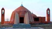
Mausoleum of Tolegatai Baba.

Kyzylorda region on map of Kazakhstan.
“The soul could protect the body from all losses, until the earthen door was closed”
Ma'arri al-Ma'arri.
Architectural complexes of Kyzylorda region.
The mausoleum of Tolegatai Baba dates back to the 11th-12th centuries, is located at an altitude of 162 meters above sea level, is located among numerous irrigation canals and rice paddies, 10 meters south of the Kylyshty ata mausoleum on the Tolegatai-Kylyshty religious complex, 11 kilometers from the eastern edge of the Kyzylkum sands, 16.5 kilometers west of the left bank of the Syrdarya River, 9.8 kilometers south-west of the village named after Mashbek Nalibaev (Akzhol), 6 kilometers south-west of the village of Abdigappar, in the Zhanakorgan district of the Kyzylorda region.
The mausoleum of Tolegatay Baba is located on a flat area, on the territory of an ancient necropolis. The complex, including the two mausoleums of Tolegatai Baba and Kylyshty Ata, was built in 2008 at the burial place of the famous batyrs Tolegetai Baba - Kylyshty Ata.
The author of the project is the architect Bek Ibraev. The complex is a group of buildings. It includes two mausoleums - round in plan (Tolegetai Baba) and rectangular (Kylyshty ata), located on a stone base - a stylobate, 4 minarets square in cross section, a main staircase.
The whole composition is oriented with the main facade to the south-west. The complex Tolegai - Kylyshty is a monument of history and culture of local importance.
Geographical coordinates of mausoleum Tolegetai-baba: N43°45'38.27" E67°04'14.82"
Geographic coordinates of Tolegetai-Baba complex: N43°45'37.16" E67°04'15.11"
Authority
Alexander Petrov.
Photos by
https://qazaqstan3d.kz/ru/place/view?id=344#gallery-2


