


![]()
You are here
Meridional ridge.

Tours of Kyrgystan.
“Every mountain top is within reach if you just keep climbing”
Barry Finlay. «Kilimanjaro and Beyond».
Tours to Central Tien-Shan mountains.
Meridional ridge is located in the eastern part of the Central Tien Shan, on the territory of the Republic of China, in the Raimbek region of the Almaty region and the Ak-Suu region of the Issyk-Kul region. The state border of three states - the Kyrgyz Republic, the Republic of China and the Republic of Kazakhstan - runs along the main ridge of the Meridional ridge.
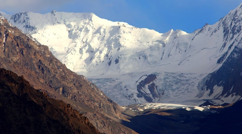
The northern, northwestern and western slopes are located on the territory of Kazakhstan. On the territory of Kazakhstan, the North Inylchek glacier is located for 11 kilometers, flowing from the western slopes of the Mramornaya Stena to peak west from the eastern and southern slopes of the ridge located in the Republic of China.
On the territory of China there are two large glaciers on the eastern slopes of the Meridional Ridge: Tugbelchik and Karagul. The southwestern and western slopes of the central part of the Meridional Range are located in the Kyrgyz Republic.
On the territory of Kyrgyzstan there are two large glaciers on the western slopes of the ridge: South and North Inylchek. The length of the Meridional Range from south to north is 72 kilometers. All the ridges of the Central Tien-Shan run in a latitudinal direction, the uniqueness of the Meridional Ridge in violation of this order is perpendicular to 90 degrees, which is why it got this name.
In the west, the Sary-Jaz ridge adjoins the Meridional ridge, to the south of which the Tengri-Too ridge is located, about 40 kilometers long, in which the Khan Tengri peak is located, 6995 meters above sea level and 7 more peaks above 6000 meters above sea level.
In the south, the northern end of the Koshaal-Too ridge adjoins the ridge. The ridge begins in the north with a depression at the headwaters of two rivers - Bayankol in Kazakhstan and Maly Muzart in China. Then it rises a step - more than 4000 meters above sea level, after which it goes to the central part - a step more than 6000 meters above sea level.
It ends with a depression on the Chinese side between the Chon-Tereksu and Kichik-Tereksu rivers. On the territory of Kyrgyzstan, the Rapasov (Bezymyanny) peak, 6814 meters above sea level, is the highest peak in the Meridional ridge.
On the territory of Kazakhstan, in the Meridional Ridge, there is a peak of 100 years of the Russian Geographical Society with a height of 6276 meters above sea level. In the central ridge of the Meridional ridge, there are ten peaks over 6,000 meters high.
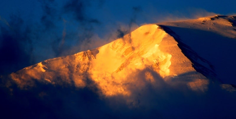
North of the central part of the Meridional Ridge is the northernmost peak in the ridge of the Marble Wall peak, 6140 meters above sea level. To the south of it there is a peak of 100 years of the Russian Geographical Society with a height of 6276 meters above sea level.
n the central part of the Meridional Ridge, there is a peak Shater Vostochny with a height of 6637 meters above sea level, from which to the south follows the peak of Richard Sorge with a height of 6210 (sometimes 6107) meters above sea level.
Further, to the south, there is the Snow Fairy Tale peak 6020 (sometimes 6200) meters above sea level. In the eastern part, there is the highest section of the Meridional Ridge with highly glacial peaks. The peak of Moris Torez with a height of 6323 meters above sea level is a nodal uplift of the ridge.
To the west of it stretches a lateral spur, crowned by the peaks of Chokan Valikhanov at a height of 6300 meters above sea level, Edelweiss at a height of 6000 meters above sea level and the Open one at a height of 5800 meters above sea level.
Otkryty Peak separates the Demchenko and Druzhba glaciers. Further, the massive pyramid of Druzhba Peak, 6800 meters above sea level, is remembered, from which, also in the western direction, stretches a lateral spur with a beautiful two-headed peak named after M.T. Pogrebetsky, 6527 meters above sea level.
Between these two lateral spurs lies the Druzhba glacier. To the south, there is Nagela peak, 6565 meters above sea level, followed by Rapasov (Bezymyanny) peak, 6814 meters above sea level, and an unnamed peak, 6747 meters above sea level, this is the last six-thousander in the southern part of the Meridional Ridge.
The Meridional ridge is separated from Pobeda Peak by the Chon-Teren pass, 5800 meters above sea level. The southern part of the Meridional Ridge is the largest node of the modern glaciation. The northern part of the Meridional Ridge drops to 4000 meters above sea level, but also carries over 30 glaciers.
The foot of the ridge is covered with meadow-steppe vegetation. Tien Shan spruce forests are replaced at an altitude of 2800 meters above sea level with subalpine and alpine meadows. Nival landscapes are developed.
There are several passes in the Meridional Ridge: Alaagyr with a height of 3870 meters above sea level (Alaaygyr River - the Saikai River), Chinese 4001 meters above sea level (Marble Wall glacier - Saikai glacier), Marble Wall 5700 meters above sea level (Marble Wall glacier - Saikai glacier), Inylchekskiy glacier with a height of 5500 meters above sea level (Demchenko glacier - Tugbelchi glacier (China)), Khrischaty (5300 meters above sea level) (Druzhba glacier - Tugbelchi glacier (China)).
Geographic coordinates of the Meridional Ridge: N42 ° 17'42.60 "E80 ° 15'32.93"

Authority:
Alexander Petrov.
"Glaciers." L.D. Dolgushin, G.B. Osipova. Series "Nature of the world." Moscow, the publishing house "Thought". 1989.
Photos by
Alexander Petrov.