You are here
MYUD pass in Zailiskiy Alatau.

Trekking in Kazakhstan and Kyrgyzstan.
“When in the spring sometimes
They want to wander their feet,
Enough dust on the old road,
On a forgotten path in Marlborough.
This path is not repaired,
Who goes there now?
Like the path of life
It curls somehow...
It's just a direction
Mapping the path.
It's just an opportunity
Go and go"
G. Thoreau.
Passes of Almaty Nature Reserve.
MYUD pass (International Youth Day) is located at an altitude of 4270 m. a. s. l., located on main ridge of Zailiskiy Alatau ridge, 335 meters to south and slightly east of MYUD peak at an altitude of 4452 m. a. s. l., 987 meters to north and slightly to west from peak of Svyazist, 4470 m. a. s. l., on territory of Almaty Nature Reserve in Talgar district, in south of Almaty region.
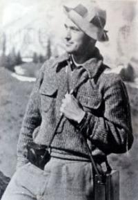
Category pass MYUD1B. The path leads through the pass from the Severtsov glacier in the Left Talgar river basin (the upper reaches of the Ulken-Mynzhilka river to the Bogatyr glacier (the South-Eastern Talgar river basin). The first ascent of the pass was made in 1935 by Khabibula Rakhimov.
Rakhimov was one of the pioneers of mountaineering in Kazakhstan, participated in the first traverse to Almatinsky Peak with an ascent through False Peak and descent along the western ridge. In 1935, he was an instructor at the alpiniad to Komsomol Peak in honor of the 15th anniversary of Kazakhstan, leading a reconnaissance detachment, and the next year he made the first winter ascent to Komsomol Peak.
In 1935 he made the first ascent of the MYUD 1B pass. In 1936, participation in an expedition to the peak of Khan Tengri, 1 winter ascent to the peak of Komsomol, since 1931, member of the OPTE (Society of Proletarian Tourism and Excursions - All-Union voluntary, which appeared on March 8, 1930 as a result of the merger of JSC "Soviet Tourist" and the Society proletarian tourism (OPT).
“The thirty-two-year-old Kazakh Rakhimov was an athlete and traveler by vocation. In Kazakhstan he gained fame as a mountaineer. He walked quickly and at the same time leisurely. In addition to composure and rare thoroughness in executing orders, he had another indispensable quality in war: the gift of orientation. Even in the dark, he seemed to see like a cat." Alexander Bek. Book "Volokolamsk Highway".
Route through MYUD pass in Zaikiskiy Alatau range.
From Solnechnaya Polyana along the right (cross from the left early in the morning) bank of the Left Talgar River, move up the valley to its confluence with the Ulken-Mynzhilki River. From this place the trail (along the Ulken-Mynzhilka River) gradually turns northwest and goes along a slope overgrown with juniper thickets.
After an hour of movement, the tongue of the Kalesnik glacier appears in the northeast. After another hour of moving to the northwest, we approach the steep tongue of the Severtsov glacier and, having gone around it, we come out onto the body of the glacier.
Climbing up the relatively flat glacier is technically simple. There are parking areas on the left side moraine of the glacier. From here the Severtsov peak is clearly visible, separating the Severtsov passes (in the west) and MYUD (in the east). To the north, the saddle of the Severtsov Pass is closed by the peak of S. Stalsky, to the west of which there is a pass of the same name.
The direct ascent to the pass from the left side moraine of the Severtsov glacier takes place along small and medium scree with a steepness of up to 30 degrees, 150 - 200 meters long and takes about 45 minutes. The tour is located on the rocks on the left side of the saddle.
The descent from the pass to the Bogatyr glacier passes along a snow-ice slope with a steepness of up to 30 degrees, and then along the right side of the glacier to a moraine lake. In total, crossing the pass to this place takes about 5.5 hours.
Geographic coordinates of MYUD pass: N43°03'52 E77°14'25
Authority:
Alexander Petrov.
http://tourclub-perm.ru/otchety_po_pokhodam/pereval_myud/
Photos by:
https://ourrocks.kz/index.php?title=%D0%A0%D0%B0%D1%85%D0%B8%D0%BC%D0%BE%D0%B2


