


![]()
You are here
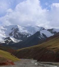
Obimazor River.
Rivers of Sangvor region of Tajikistan.
“Of course, there are still places in the Pamirs where you can only get through narrow paths on horseback or on foot, but trucks can easily get to the main settlements.”
Eduard Makarovich Murzaev.
Rivers of Mazor Range.
Obimazor River, flowing along southern slope of Mazor ridge and northern slopes of Darvaz ridge, is located on territory of Tajik National Park, in Sangvor region, Republic of Tajikistan. The Obimazor River, 35 kilometers long, originates from the end of the Mazorsky glacier at an altitude of 3256 meters above sea level.
The river receives its sources from the southern slopes of the Mazor ridge, from the eastern slopes of the meridional ridge Darkharvak and the western slopes of the Darvaz ridge. The mouth of the river is located at an altitude of 2187 meters above sea level, the river is a left tributary of the Obihingou River.
Geographic coordinates of Obimazor River: N38°40'38 E71°26'19
Right tributaries of Obimazor River.
River Zhungar-Vinok.
At 7.5 kilometers from the beginning of the sources of the Obimazor River, the first tributary, Zhungar Vinok, flows in on the right, 3.6 kilometers long. The river receives its sources from the glacier of the same name, at an altitude of 3939 meters above sea level, located on the southern slope of the Mazor ridge. The mouth of the river is located at an altitude of 2880 meters above sea level. In the middle part the river flows in a narrow canyon.
Geographic coordinates of Zhungar-Vinok River: N38°41'32 E71°27'23
Bursit River.
At 8.2 kilometers from the beginning of the sources of the Obimazor River, a tributary, Bursit, flows in on the right, with a length of 3.4 kilometers. The river receives its sources from the glacier of the same name, at an altitude of 4132 meters above sea level, located on the southern slope of the Mazor ridge.
The length of the Bursit glacier, located on the southern slope of the Mazor ridge, is 1.6 kilometers. The area of the glacier reaches 0.44 square kilometers, the perimeter of the glacier is 4.31 kilometers. The upper boundary of the glacier is located at an altitude of 5116 meters above sea level. The mouth of the river is located at an altitude of 2859 meters above sea level.
Geographic coordinates of Bursit River: N38°41'26 E71°26'54
Washo River.
At 8.7 kilometers from the beginning of the sources of the Obimazor River, a tributary, Vosho, flows in on the right, 4 kilometers long. The river receives its sources from the glacier of the same name, at an altitude of 4046 meters above sea level, located on the eastern slope of the meridional ridge Darkharvak.
The length of the Vosho glacier, located on the eastern slope of the Darkharvak ridge, is 1.6 kilometers. The area of the glacier reaches 0.84 square kilometers, the perimeter of the glacier is 4.37 kilometers. The upper boundary of the glacier is located at an altitude of 4461 meters above sea level. The mouth of the river is located at an altitude of 2852 meters above sea level.
Geographic coordinates of Vosho River: N38°40'24 E71°25'50
Jurihat River.
At the 11th kilometer from the beginning of the sources of the Obimazor River, a tributary, Jurihat, flows in on the right, 3.2 kilometers long. The river receives its sources from a small glacier of the same name, at an altitude of 4118 meters above sea level, located on the southern slope of the Mazor ridge.
The length of the Jurihat glacier, located on the southern slope of the Mazor ridge, is 610 meters. The area of the glacier reaches 0.07 square kilometers, the perimeter of the glacier is 1.26 kilometers. The upper boundary of the glacier is located at an altitude of 4816 meters above sea level. The mouth of the river is located at an altitude of 2802 meters above sea level.
Geographic coordinates of Jurihat River: N38°41'44 E71°25'17
River Obi Borshid (Sharak).
At the 12th kilometer from the beginning of the sources of the Obimazor River, a tributary flows in from the right - Obi Borshid, with a length of 3.2 kilometers. The river receives its sources from a small glacier of the same name, at an altitude of 3729 meters above sea level, located on the southern slope of the Mazor ridge.
The length of the Jurihat glacier, located on the southern slope of the Mazor ridge, is 4.1 kilometers. The area of the glacier reaches 3.65 square kilometers, the perimeter of the glacier is 12.28 kilometers. The upper boundary of the glacier is located at an altitude of 5298 meters above sea level. The mouth of the river is located at an altitude of 2775 meters above sea level.
Geographic coordinates of Obi Borshid (Sharak) River: N38°42'07 E71°24'08
Shirak River.
At the 14th kilometer from the beginning of the sources of the Obimazor River, a tributary, Shirak, flows in on the right, 3.6 kilometers long. The river receives its sources from a small glacier of the same name, at an altitude of 4189 meters above sea level, located on the southern slope of the Mazor ridge.
The upper boundary of the glacier is located at an altitude of 4529 meters above sea level. The mouth of the river is located at an altitude of 2654 meters above sea level.
Geographic coordinates of Shirak River: N38°41'36 E71°22'51
Obi Nusay River.
At 24.2 kilometers from the beginning of the sources of the Obimazor River, a tributary flows in from the right - Obi Nusay, with a length of 7.5 kilometers. The river receives its sources from a small glacier of the same name, at an altitude of 3637 meters above sea level, located on the southern slope of the Mazor ridge.
The length of the Obi Nusay glacier, located on the northern slope of the Arvak ridge, is 4.79 kilometers. The area of the glacier reaches 5.44 square kilometers, the perimeter of the glacier is 12.55 kilometers. The upper boundary of the glacier is located at an altitude of 4779 meters above sea level. The mouth of the river is located at an altitude of 2402 meters above sea level.
Geographic coordinates of Obi Nusai River: N38°45'33 E71°22'44
Duvadg River.
At 27.5 kilometers from the beginning of the sources of the Obimazor River, a tributary, Duvadg, flows in on the right, 4.8 kilometers long. The river receives its sources from a glacier at an altitude of 4382 meters above sea level, located on the southwestern slope of the Mazor ridge.
There are no glaciers in the upper reaches of the river. The mouth of the river is located at an altitude of 2334 meters above sea level.
Geographic coordinates of Nodru River: N38°42'25 E71°16'17
Obi Zangi River.
At 30.6 kilometers from the beginning of the sources of the Obimazor River, a tributary flows in from the right - Obi Zangi, with a length of 4.8 kilometers. The river receives its sources from a glacier, at an altitude of 3845 meters above sea level, located on the northern slope of the Darvaz ridge.
The glacier has three branches. The western branch of the Obi Zangi glacier reaches 3.4 kilometers. The length of the central branch of the Obi Zangi glacier is 1.7 kilometers, located on the northern slope of the Darvaz ridge. The upper boundary of the glacier is located at an altitude of 4357 meters above sea level. The mouth of the river is located at an altitude of 2265 meters above sea level.
Geographic coordinates of Obi Zangi River: N38°40'35 E71°09'30
Right tributaries of Obi Zangi River.
Obiharek River.
At an altitude of 3129 meters above sea level, the Obi-Zangi tributary, 6 kilometers long, flows into the Obi Zangi on the right. The Obikharek River originates at an altitude of 3863 meters above sea level from 4 branches of glaciers located on the northern slope of the Darvaz ridge.
Geographic coordinates of Obiharek River: N38°40'35 E71°09'30
Jifat River.
At an altitude of 2771 meters above sea level, the Jifat tributary, 7.6 kilometers long, flows into the Obi Zangi on the right. The Jifat River originates at an altitude of 3863 meters above sea level from 4 branches of glaciers located on the northern slope of the Darvaz ridge.
Geographic coordinates of Jifat River: N38°40'32 E71°10'40
Zotkin River.
At an altitude of 2771 meters above sea level, the Zotkin tributary, 7.5 kilometers long, flows into the Obi Zangi on the right. The Dzhifat River originates at an altitude of 4056 meters above sea level from the Zotkin glacier located on the northern slope of the Zotkin ridge with a length of 20 kilometers.
Geographic coordinates of Zotkin River: N38°40'47 E71°12'37
Khurdzhin River.
At 31.7 kilometers from the beginning of the sources of the Obimazor River, a tributary, Khurdzhin, flows in on the right, 8 kilometers long. The river receives its sources from a small glacier, at an altitude of 3973 meters above sea level, located on the western slope of the Mazor ridge. The mouth of the river is located at an altitude of 2252 meters above sea level.
Geographic coordinates of Khurdzhin River: N38°46'28 E71°16'50
Left tributaries of Obimazor River.
Arnavad River.
At 6.5 kilometers from the beginning of the sources of the Obimazor River, the first tributary, Arnavad, 3.2 kilometers long, flows in from the left. The river receives its sources from the Darvazsky glacier, at an altitude of 3109 meters above sea level, located on the northern slope of Darvazsky and on the eastern slope of the Arvak ridges. The mouth of the river is located at an altitude of 2909 meters above sea level
Geographic coordinates of Arnavad River: N38°39'23 E71°27'25
Virzgakh River.
At 15.9 kilometers from the beginning of the sources of the Obimazor River, a tributary, Virzgakh, flows in on the left, with a length of 9.3 kilometers. The river receives its sources from a small glacier of the same name, at an altitude of 3884 meters above sea level, located on the southern slope of the Mazor ridge.
After 2.6 kilometers, a deep tributary flows into Virzgah on the left, originating from a glacier located on the northern slope of the Arvak ridge. The length of the Virzgakh glacier, located on the northern slope of the Arvak ridge, is 5 kilometers. The area of the glacier reaches 5.63 square kilometers, the perimeter of the glacier is 13.59 kilometers.
The upper limit of the glacier is located at an altitude of 5112 meters above sea level. The mouth of the river is located at an altitude of 2573 meters above sea level.
Geographic coordinates of Virzgakh River: N38°40'49 E71°21'40
River Darkharvak.
At 17.8 kilometers from the beginning of the sources of the Obimazor River, a tributary, Darkharvak, flows in on the left, 24 kilometers long.
Darkharvak glacier.
The river receives its sources from the Darkhvarvak glacier, at an altitude of 3727 meters above sea level, located at the junction of the ridges: Darvazsky with a length of 203 kilometers, Kuhiruzak with a length of 30 kilometers and Kuhibunay with a length of 12 kilometers.
The complex valley glacier Darkharvak consists of 5 branches and belongs to the basin of the Darkharvak and Obimazor rivers. The length of the Darkharvak glacier, located on the northern slope of the Darvaz ridge, is 7 kilometers. The area of the glacier reaches 32.04 square kilometers, the perimeter of the glacier is 57.11 kilometers.
The upper boundary of the glacier is located at an altitude of 5387 and 5131 meters above sea level. In the upper reaches of the Darkharvak glacier, the Bunai pass is located at a height of 4598 meters above sea level.
Geographic coordinates of Darkharvak glacier: N38°30'15 E71°25'52
The mouth of the river is located at an altitude of 2504 meters above sea level. Darkhvarvak has: 18 left and 14 right tributaries.
Geographic coordinates of Darkharvak River: N38°36'20 E71°18'54
Left tributary of Darkharvak River.
River Darai Zotkin.
At the 20th kilometer, the Dara Zotkin tributary, 9.8 kilometers long, flows into the Darkharvak River on the left. The river receives its sources from the glacier of the same name, at an altitude of 3663 meters above sea level, located on the southeastern slope of the Darvaz ridg
The Dara Zotkin River flows between the eastern slopes of the submeridional Zotkin ridge, 20 kilometers long. The length of the Zotkin glacier, located on the northern slope of the Arvak ridge, is 4.4 kilometers. The tongue of the Zotkin glacier is flat, located under a layer of moraine sediments, located at an altitude of 3800 meters above sea level, flat.
Open ice is exposed in the middle reaches at the confluence of tributaries. In the upper reaches of the Darai Zotkin valley, near the tongue of the Zotkin glacier, in the rocky wall of the right slope, a gap is visible above the step of the “ram’s foreheads”, on which the tongue of the right branch of the Zotkin glacier lies.
Above the stream flowing from under the Jitfat pass there is an icefall flowing down from under the pass; a snow plateau can be seen above it. At the mouth of the Darai Zotkin River, on the left bank there are the ruins of a village at an altitude of 2700 meters above sea level, here a path has been laid along a large scree.
Geographic coordinates of Darai Zotkin River: N38°36'58 E71°15'13
The length of the Zotkin glacier, located on the northern slope of the Arvak ridge, is 5 kilometers. The area of the glacier reaches 5.63 square kilometers, the perimeter of the glacier is 13.59 kilometers. The upper boundary of the glacier is at an altitude of 5112 meters above sea level. The mouth of the river is located at an altitude of 2506 meters above sea level.
Geographic coordinates of Darai Zotkin River: N38°39'19 E71°19'15
Nodru River.
At 27.4 kilometers from the beginning of the sources of the Obimazor River, a tributary, Nodru, flows in on the left, with a length of 7.3 kilometers. The river receives its sources from a glacier at an altitude of 3637 meters above sea level, located on the southern slope of the Mazor ridge.
The length of the Nodru glacier is 2.2 kilometers, located on the northeastern slope of the Zotkin ridge with a length of 20 kilometers. The upper boundary of the glacier is located at an altitude of 4654 meters above sea level.
Geographic coordinates of Nodru glacier: N38°40'00 E71°15'13
The mouth of the river is located at an altitude of 2338 meters above sea level.
Geographic coordinates of Nodru River: N38°42'25 E71°16'17
Authority and photos by:
Alexander Petrov.