


![]()
You are here
Origin of word Pamir.
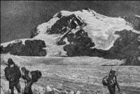
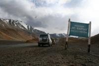
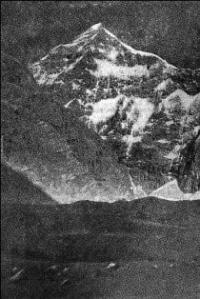
Photo tours in mountains of Pamir.
"You have to travel all your life, until the last breath ..."
Nature of Pamir mountains.
The question of the origin of this famous geographical name turned out to be so complex that even among scholars on this subject, there is no consensus. Everyone agrees on only one thing - that the name is very ancient and cannot be revealed using modern languages, Tajik or Kyrgyz.
For the first time in literature, the word "Pamir" is mentioned in the notes of the Chinese traveler Xuan-Tsang, who in the VIIth century visited the countries with the origins of Amu-Darya for diplomatic purposes. According to local residents, Xuan-Tsang wrote that the Po-mi-lo country stretches between two snow ridges, in which cold and wind reign, the snow falls in winter and summer, the soil is saturated with salt and covered with stones.
But, of course, the name "Po-mi-lo" is not Chinese. Xuan Zang wrote it in his own way, breaking it into syllables. This name corresponds to the Pamirs, no doubt: after all, in Chinese, the letter "p" is not spelled. This name is found in the works of the IXth-Xth centuries: “Famir” or “Bamir” - they wrote differently.
Many believe that the Arabs borrowed this name from the Indians. In Indian mythology there is Mount Meru, which is supposedly located in the center of the world. In Buddhist geography, the Himalayas and Southern Tibet were considered the center of the world.
Hence the assumption that “Upa-Meru”, that is, “the country lying under Meru” is “(y) pamer (y)” or “Pamir” (“Famir”, “Bamir” in Arabic works). Marco Polo, who traveled to the Pamir in the XIIIth century, writes this name in his notes - “Pamer” or “Pamier”.
Scientists have long drawn attention to the fact that many geographical names in the upper Indus and Amu Darya are similar: Pamir, Kashmir, Tirichmir, Aimir and so on. The view was expressed that the Sanskrit word “peace”, meaning “lake”, lies in the basis of these names (there are really many lakes in the Pamirs).
But to prove such an origin of the word "Pamir" was difficult, the first syllable was not explained in the old Persian composition of the XVIth century Mirza-Gaidar, we again meet the name "Pamir" or "Bamir". Iranian linguists have suggested that the "Pamir" is the Persian word "Bam-iar", which means "the roof of the earth."
Maybe this is where the famous definition of “the roof of the world” came from, although many consider it to be a translation from the Tajik “Bom-i-dunye”. There were other interpretations from the Persian, for example, "Po-i-mor", that is, "the foot of death" or "Po-i-murg" - "the foot of a bird."
All these names, however, are devoid of geographical meaning. Relatively recently, first by the Uzbek geographer X. K. Khasanov, then professor N. G. Malitsky made an assumption that can be accepted as quite probable. In Afghanistan, they still do not write the Pamir, but Pa-e-Mir. “Mihr” or “Miter” is the sun god of the ancient Iranians, and the word “Pa-i-mihr” should mean “the foot of the sun or the sun god”, that is, a mountainous country in the east, from which the sun comes out.
In relation to the lands inhabited by the ancient Iranian peoples, the Pamir really occupies such a position, and the given name reflects this well. It is possible that the word "Pamir" came from him. “Probably” and not “for sure.” The very ancient word “Pamir” is not at all easy to find its roots.
But if you ask several scientists to show you the Pamir on the map, it may turn out that everyone will show it in different ways, and then a long-standing dispute will arise between them - in what borders should the Pamirs be accepted? This dispute has been around for a hundred years, and there is still no consensus.
What is the matter? Is our geographical science still so weak that it cannot answer the question asked with confidence? The fact is that there are too different approaches to establishing the natural borders of the Pamir. To understand these doubts, we will briefly talk about the main features of the nature of the Pamir.
This alpine country is located almost in the center of the Asian mainland. On all sides it is surrounded by powerful 'high ridges: in the south - the Hindu Kush, in the north by the Tien-Shan mountains, in the east - by the spurs of the Chinese Kunlun ridge, in the west - by the mountains of northeastern Afghanistan. The height of these ridges often exceeds 7,000 m. a. s. l.
They form a natural enclosure that impedes the penetration of moist oceanic air inside. Therefore, the Pamir has a very dry climate. On its territory, precipitation sometimes falls as little as in the Kara-Kum desert, and often much less.
Because of this, all other natural features sharply differ from the highlands adjacent to the Pamir, glaciers and snowfields in the Pamir mountains are much higher than in neighboring areas, forests and meadows are found only in spots and stripes along rivers and streams, and the very slopes are covered with dry desert, steppe and the so-called "pillow" vegetation.
Huge areas are occupied by scree and rocks, the main color background in the mountains is grayish and brown. A completely different matter in the Caucasus or in the Tien Shan: there the slopes are green, covered with forests, lush grasses.
The geology of the Pamir mountains is young. They were raised to such a great height only a few million years ago. Prior to this, the territory of the Pamir represented The surface of the climate has become colder. After all, the higher the colder: in Central Asia, for every 100 meters of elevation, the temperature drops by an average of 0.6 °.
Moisture coming from the oceans began to accumulate on the peaks in the form of glaciers and firn fields. Gradually, the glaciers, increasing in size, began to slide into the valleys, smoothing the slopes and sometimes completely filling the bottoms of the valleys.
Such trough-like across, flattened by a glacier, the so-called “trough” valleys are often found in the Pamir. And then the mountains reached such a considerable height, and fenced off the country from the oceanic moist air masses. The climate became dry, the area of glaciers began to decline.
Stormy muddy streams of water erupted from under the melting glaciers, eroding the valleys and crashing into their bed. This is where what happened subsequently gave rise to disputes among scientists about the borders of the Pamirs. The fact is that the flow of rivers from under the glaciers was directed along tectonic cracks, the flows flowed mainly to the west, flowing into the river, which is now called Pyanj.
For millennia, glacial streams crashed into the surface of the western part of the country, breaking it into powerful ridges and narrow deep valleys with steep slopes covered with a rocky cloak of talus. And the glaciers that gave rise to rivers flowing westward covered the eastern part of the Pamir with a continuous shield.
They calmly smoothed their bed, and when melted, they exposed wide gently sloping valleys and lake basins covered with glacial deposits. The bottom of these valleys and hollows lies at a great height of 3500-4000 m. a. s. l. It so happened that the territory of the country was unevenly dissected by rivers.
The western part began to be distinguished by large contrasts of heights, a significant steepness of the slopes, narrow and deeply incised valleys. Specialists call such a relief “erosive”. In the east, an alpine, but very smooth relief was formed with wide valleys and closed lake basins, separated by relatively low, rising from the bottom only 1.5-2 kilometers ridges with gentle slopes.
Such a relief is called "accumulative." In the highlands, it is rare, within Asia - mainly in Tibet. It was in the last century that the view was expressed that the Pamir should be called precisely this upland part of the country, and not the territory lying to the west of it with an erosive relief.
Proponents of such a narrow understanding of the Pamir’s volume proceeded from a sharp difference in landforms, indicating, among other things, that the word “Pamir” among the local population has become a household term for a certain type of terrain, namely a high deserted and deserted place.
This, of course, is true. In geographical literature, the word "Pamir" is often found. The impression was that the Pamir were not one, but several. In the common sense of the word, it was so. For example, Karakulsky Pamir, Alichursky Pamir, etc. were singled out.
Some common scientists used this common term in the last century and proposed to assign it to the upland territory, now known as the "Eastern Pamir". When the territory of this mountainous country began to be studied by powerful integrated expeditions, it was found that between the eastern and western parts, despite the difference in relief, there is a significant commonality in the geological structure, types of vegetation, climate and soil, in the processes of relief development, etc.
When such unity was established, the term "Pamir", as a proper name, was assigned to the entire territory of the Gorno-Badakhshan Autonomous Region. Since then, the Pamir has been accepted by most experts within these borders. Only the mountainous part of the Pamirs is called the Eastern Pamir, and rugged in deep valleys - the Western Pamir.
These names received the right to citizenship and were entrenched in scientific and educational literature. However, proponents of a narrow understanding of the Pamir, in support of their concept, continued to provide ever new evidence of the isolation of the Eastern Pamir.
The relief there is different, and plant formations differ from the Western Pamir, and it is much colder in the east, and the population there is different than in the west. To finally limit the Pamir to one highland, supporters of this trend suggested that the Western Pamir be called Badakhshan, thereby emphasizing its fundamental difference from the Eastern Pamir, which only recognized the right to be called the Pamir.
Meanwhile, as science accumulates new data on the nature of the Pamirs and related areas, the idea of the natural unity of both parts of the country was confirmed by additional materials. It was found that the differences in climate, vegetation and soils are only particular, lying within the same type, that before the ice age, the geological development of both parts of the Pamir went the same way, that the difference between the Western and Eastern Pamir is much smaller than between the whole Pamir and neighboring wetter highlands.
So another hypothesis arose, proving that the Pamir is not limited to state borders, but covers all the dry highlands of this part of Asia between the Zaalaysky ridge on in the north, the Hindu Kush in the south, the Kashgar ridge in the east and the Afghan Kokhi-Lal ridge in the west.
The first two ridges stretch from west to east, the last two from north to south. Within such borders, the Pamir, as an alpine and at the same time dry country, has the outlines of an irregular quadrangle and occupies an area almost twice the territory of the Gorno-Badakhshan Autonomous Region and four times larger than the area of the Eastern Pamir.
It is this broad concept of the Pamir that the author of the book adheres to, who has worked in this alpine region for many years. The argument is not over yet. Only abundant factual material, which is increasingly accumulated by researchers, can solve it.
Within the specified wide borders, the natural region of the Pamirs, due to historical reasons, was divided between the three states. About 2/3 of the Pamir territory is covered by the Gorno-Badakhshan Autonomous Region of Tajikistan, the Kashgar Pamir is part of the Xin-Jiang region of the People’s Republic of China, the Hindu Kush Pamir (northern slopes of the Hindu Kush) and part of the Western Pamir (eastern Afghanistan Badakhshan) belong to the kingdom of Afghanistan.
Authority:
Pamir - The Roof of the World. Collection of works and photos about the Pamir. Compiled by Mina Mingaleeva. 1987 year. Book of O. Agahanyants "Between the Hindu Kush and the Tien Shan." Photos from the book "Pamir", the publishing house "Planet", 1987, edited by corresponding member of the USSR Academy of Sciences M.S. Asimova. Also used photographs Ischuk N.R.