


![]()
You are here
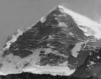
Peak of Karl Marx.
Peaks of Shahdarya Range.
“Here the mountains are not offended by the sun,
And on February evenings
The windows of our hut are burning,
Interfering with the sleep of the big mountains."
Yuri Vizbor. "Hut". 1962.
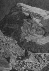
Climbing peak of Karl Marx in Pamirs.
he peak of Karl Marx with a height of 6723 meters above sea level is located in the central part of the Shakhdarya Range in the southwestern part of the Pamir Mountains, in the Ishkashim district of the Gorno-Badakhshan Autonomous Region in southern Tajikistan.
Karl Marx Peak is a huge triangular pyramid with an almost sheer northern wall, a two-kilometer plumb line that breaks off to the glaciers of the lower slopes. Above the wall, at the very top of the peak, a powerful snow-ice cap dazzlingly sparkling in the sun with virgin snows.
Karl Marx Peak is located 3.8 kilometers southwest of Engels Peak, 6507 meters above sea level. The height of the Karl Marx peak is indicated on the basis of information from a topographic map at a scale of 1:200000. In various reference materials, the height is indicated as 6726 meters above sea level.
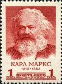
The total area of glaciers located on the top of Karl Marx is 120 square kilometers. The original name of the peak - the peak of the King of the Peacemaker, was given at the end of the XIXth century by the first Russian explorers of the southern part of the Pamirs, in honor of Emperor Alexander III. In Soviet times, the peak was renamed after the communist theorist Karl Marx.
History of first ascents to peak of Karl Marx in Shakhdarya ridge.
1937
The first information about the high-mountainous zone of the southwestern Pamir dates back to 1937, being the result of a large and complex work carried out by the talented geologist S.I. Klunnikov (died in the battles of the Great Patriotic War) in these desert and harsh mountains.
Klunnikov, penetrating from the gorge of the river. Gunt to the central node of the Rushan Range, was the first to discover and describe the peak rising above a powerful glacier, which, according to the researcher’s measurements, reached a height of 7130 meters above sea level (more accurate measurements of recent years have shown that the peaks described by S.I. Klunnikov, do not reach 7000 meters above sea level).
However, the lack of the necessary high-mountain sports training and appropriate equipment, which is so characteristic of a significant circle of our geologists, did not allow him to make a more detailed survey of the ridge. In another, even more remote from settlements, area of the upper reaches of the Shakh-Dara River, in the ridge of the same name with the river, Klunnikov described peaks reaching significant heights - the peak of Karl Marx and Engels, the first of which, according to the researcher, reached a height of 7000 meters above the level my.
However, the nature and scheme of glaciation, as well as the approaches to the peaks, remained unexplored. Subsequently, the geologist Barkhatov carried out significant work on updating the maps of some regions of the southwestern Pamir.
1946
The first ascent to the top of the peak was made by Soviet climbers (E. Beletsky, E. Abalakov, A. Bagrov, E. Ivanov, P. Semyonov, A. Sidorenko and A. Ugarov) under the guidance of E. Beletsky. Exploration of the Rushan Range was carried out in the area of Patkhor Peak. Having successfully completed the first part of this expedition, in the second half of August the expedition caravan crossed the Shugnan Range through the Duzakh-Dara Pass, and along the valley of the Regig River approached the peak of Karl Marx.
Two reconnaissance groups went to the foot of the peak along the valleys of the Shabai and Khatsak rivers, after which the climbing route was chosen from the Khatsak glacier, through the Nishgar pass to the Marx plateau, and further along the Western ridge.
For the first time on the summit of Karl Marx on September 6, 1946, at 13:30, in difficult weather conditions seven people got up. E. Beletsky, E. Abalakov, A. Bagrov, E. Ivanov, P. Semenov, A. Sidorenko and A. Ugarov.
After climbing to the top, E. Beletsky climbed the pass in the eastern part Shahdarinsky ridge, east of Engels peak, (Border guards pass). The expedition ended in early October 1946.
1970
The northern 2-kilometer wall in the form of a huge rocky triangle, leaving its plumb lines endlessly into the sky, has always attracted climbers, but for the first time Fyodor Zhitenev's team ventured to try their luck on it by conquering the wall.
1976
Yuri Shevchenko's team passed through the center of the Northern Wall, solving the problem of passing an almost sheer rocky belt - the "TV" and a white quartz belt in front of it. The northern exposure of the wall requires high technical and psychological preparedness from the group, so that during the ascent the participants do not get frostbite or simply do not freeze.
Geographic coordinates of Karl Marx Peak: N37°09'48.39" E72°28'54.65"
Authority and photos:
Alexander Petrov.
http://www.mountain.ru/article/article_display1.php?article_id=5417