


![]()
You are here
Petroglyphs of Saymaluu-Tash.


Ancient Petroglyphs Kyrgyzstan.
“The language of light can only be decoded by the heart”
Welcome to Petroglyphs in Kyrgyzstan.
Saimaluu-Tash State Park, with an area of 32 hectares, was formed on May 25, 2001, in eastern part of Jalal-Abad region, in Toguz-Torous region, south of village of Kazarman in mountains of Ferghana Range in mountains of Ayrimach-tauymaly Tash, at altitudes of 3000 - 3200 m. a. s. l., along Curart River.
Saymaly-Tash It is located on the eastern slope of the Fergana Range, in the upper reaches of the Fergana high valley at an altitude of 3,000 - 3,400m, near the Kekart (Kugart) pass, 80km north-east of Jalal-Abad City, on the administrative territory of the Toguz-Torous district.
Saymaly-Tash Gorge is located in an area of permanent snow and is only accessible during a short period – no more than 20 days a year in July-August; then, groups of herdsmen with sheep and goat herds get there from the Fergana Valley.
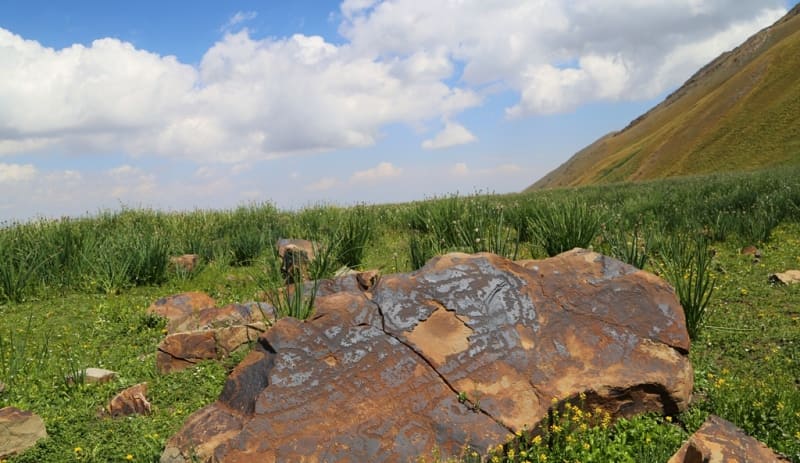
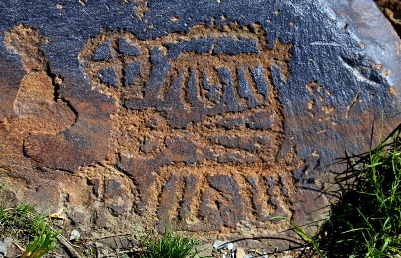
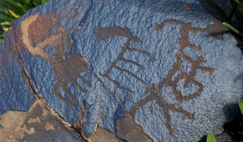
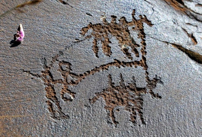
Description of the Site. The petroglyphs are in two adjoining valleys (Saymaly-Tash I and Saymaly-Tash II), divided by an eastern offshoot of the Saymaly-Tash Range. They are mainly made by dotted chipping 0.5cm to 1cm and sometimes 0.2 - 0.4cm deep on smooth facets of fragmented rock covered with a crust of intensive dark brown patina sometimes up to 6 mm thick (Bernshtam 1997: 390; Tashbaeva 2004: 97 - 98).
Carvings are also found, especially with medieval petroglyphs. There is no specific consistency in the arrangement of drawings, i.e. all surfaces were used, oriented toward cardinal points and in intermediate directions, as well as pointing upwards.
Saymaly-Tash has small-sized -mainly 10 - 12cm – petroglyphs and miniature (3 - 5 cm) ones with a thorough depiction of details. The main specific feature of Saymaly-Tash is its vast number of petroglyphs and diversity of styles and motifs created within a significant time period, which enables researchers to consider it one of the largest rock art sites not only in Central Asia, but also in the world.
The number of rocks and drawings has so far defied an accurate determination. According to Rogozhinskiy A.E. (2008: 87), data provided by Bernshtam A.N. and Tashbaeva K.I. appear the most accurate: 10,000 rocks and over 100,000 petroglyphs (Bernshtam 1997: 393; Tashbaeva 2004: 97, only for Saymaly-Tash I).
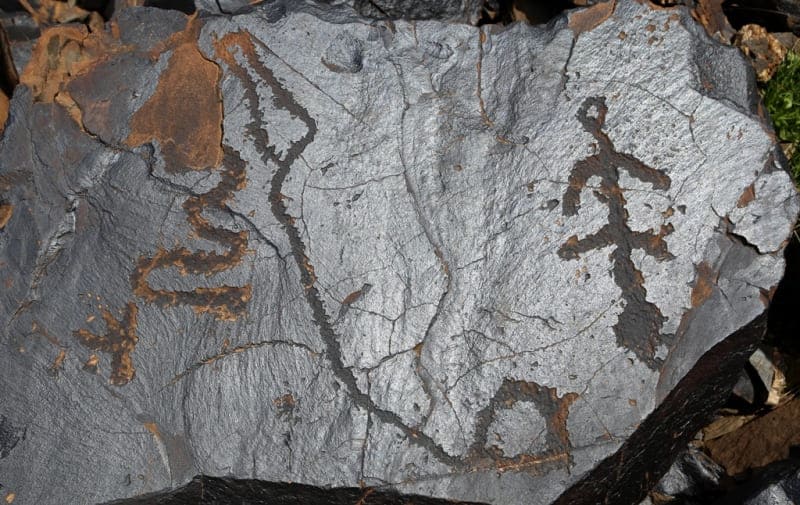
Most researchers today date Saymaly-Tash petroglyphs from the second half of the 3rd / beginning of the 2nd millennium BC to the Middle Ages. The earliest, according to all accounts, are drawings made in a geometric style dated to the Eneolithic and Bronze Ages.
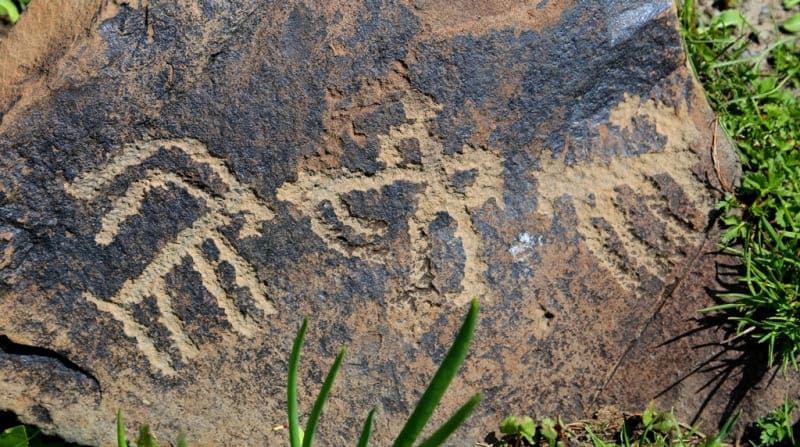
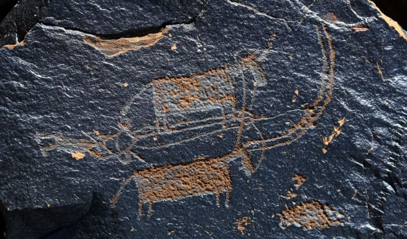
The Early Iron Age is represented by a realistic drawing technique with prominent manifestations in the Scythian and Saki zoomorphic style. In the Middle Ages, straight lines and a sketchy style prevail. The diversity of the Saymaly-Tash motifs and compositions results from its colossal number of petroglyphs, the interaction of various cultures and an extensive chronological range.
Their classification proposed in 1952 by Bernshtam was then successfully clarified and detailed by modern researchers. Several main groups of motifs stand out with individual and group depictions of animals, hunting scenes, various ceremonial and ritual images and scenes, geometric motifs, landscape elements, household items and others.
ssues of dating, genesis and cultural attribution of the site are currently under discussion. Rock Art in Central Asia 54 Research Status of the Site. Saymaly-Tash was discovered in 1902 by Khludov N.G. and surveyed in 1946 by Zima B.M. A scientific description of the site was for the first time provided by Bernshtam in 1952.
In the second half of the XXth century, Sher Ya.A., Martynov A.I. (Kemerovo, Russia), Maryashev A.N., Rogozhinskiy A.E. (Almaty, Kazakhstan), Pomaskina G.A., Tashbaeva K.I. (Bishkek, Kyrgyzstan), and Francfort H.P. (CNRS, France) studied the site.
The last scientific survey of the site was done in 2002 by a group led by Tashbaeva K.I. In 2007, the site was examined by an association of the Department of Archeology and Ethnography of KSU named after Dzhusup Balasagyn.
The access to the site is difficult and specific climatic conditions protect it from excessive human impact, thus ensuring its safekeeping.
However, in recent years, a number of Kyrgyzstan tourist agencies have been attempting to arrange for regular commercial horseback routes to Saymaly-Tash for foreign and local well-to-do tourists. Protection and Management. Saymaly-Tash is on the UNESCO Tentative List for Kyrgyzstan and is registered by the government in the List of Sites of National Importance. Its borders and protection zone have not yet been established.
In 2001, the site was awarded the status of a National Nature Park with an area of 32,000 ha. The agency’s office responsible for its management and protection is in the Kazarman village. Saimaluu-Tash is included in the Tentative UNESCO World Heritage List from Kyrgyzstan and is registered by the state in the List of Monuments of National Importance of the Kyrgyz Republic.
The boundaries of the monument and the buffer zone are not defined.
Geographical coordinates of rock paintings of Saimaluu-Tash: N41°10'47 E73°48'53
Authority:
«Rock Art in Kyrgyzstan». Bakyt Amanbaeva, Aiday Suleymanova, Chynarbek Zholdoshev.
Photos by:
Alexander Petrov.